Difference between revisions of "2016-04-03 49 8"
imported>DODO (→Expedition) |
imported>FippeBot m (Location) |
||
| (5 intermediate revisions by one other user not shown) | |||
| Line 33: | Line 33: | ||
== Expedition == | == Expedition == | ||
<!-- how it all turned out. your narrative goes here. --> | <!-- how it all turned out. your narrative goes here. --> | ||
| − | I've planned to exceed the way back for 5 more kilometers to get a | + | I've planned to exceed the way back for 5 more kilometers to get a tron, but I missed a turn behind Dannstadt and so I missed the tron anyway. Nevertheless I choose the slightly longer way back home for the sunny weather. The hash was on grassland 40 m next to an asphaltic way, so it was a less than 5 minutes break to stop, go there, take some pictures and continue the ride. All in all it had taken less than two hours. |
== Tracklog == | == Tracklog == | ||
<!-- if your GPS device keeps a log, you may post a link here --> | <!-- if your GPS device keeps a log, you may post a link here --> | ||
| + | [https://www.komoot.de/tour/8385432 56 KM of bull-riding] | ||
== Photos == | == Photos == | ||
| Line 42: | Line 43: | ||
Image:2012-##-## ## ## Alpha.jpg | Witty Comment | Image:2012-##-## ## ## Alpha.jpg | Witty Comment | ||
--> | --> | ||
| − | <gallery perrow=" | + | <gallery perrow="4"> |
| + | Image:2016-04-03_49_8-1.jpg|view to the east | ||
| + | Image:2016-04-03_49_8-2.jpg|the west (Palatine forest in the background) | ||
| + | Image:2016-04-03_49_8-5.jpg|the north | ||
| + | Image:2016-04-03_49_8-4.jpg|the south (bull in the background) | ||
| + | Image:2016-04-03_49_8-6.jpg|the hasher | ||
| + | Image:2016-04-03_49_8-7.jpg|the hasher | ||
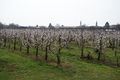
| + | Image:2016-04-03_49_8-8.png| cherries are already in flower | ||
</gallery> | </gallery> | ||
| Line 49: | Line 57: | ||
<!-- Add any achievement ribbons you earned below, or remove this section --> | <!-- Add any achievement ribbons you earned below, or remove this section --> | ||
| − | |||
| − | |||
| − | |||
| − | |||
| − | |||
| − | |||
| − | |||
| − | |||
| − | |||
| − | |||
| − | |||
| − | |||
[[Category:Expeditions]] | [[Category:Expeditions]] | ||
| − | |||
| − | |||
| − | |||
| − | |||
| − | |||
| − | |||
| − | |||
[[Category:Coordinates reached]] | [[Category:Coordinates reached]] | ||
| + | {{land geohash | ||
| + | | latitude = 49 | ||
| + | | longitude = 8 | ||
| + | | date = 2016-04-03 | ||
| + | | name = DODO | ||
| + | }} | ||
| − | + | {{consecutive geohash | |
| − | + | | count = 8 | |
| − | + | | latitude = 48 | |
| − | + | | longitude = 8 | |
| − | + | | date = 2016-03-27 | |
| − | + | | name = DODO | |
| − | + | }} | |
| − | + | {{location|DE|RP|RP}} | |
| − | |||
| − | |||
| − | |||
| − | |||
| − | |||
| − | |||
| − | |||
| − | |||
Latest revision as of 00:06, 16 August 2019
| Sun 3 Apr 2016 in 49,8: 49.4860657, 8.2538264 geohashing.info google osm bing/os kml crox |
Location
A grassland next to Birkenheide.
Participants
Plans
After all the walking of last week I didn't want to go out and the hash is 22 KM away - far enough, that I don't have to go, but it's only 25 KM to go there by bike, because there is a road that leads there almost directly (I had to walk 25 kilometers to the hash, that was only 16 km away three days ago). And with the bull it will be done in around two hours.
Expedition
I've planned to exceed the way back for 5 more kilometers to get a tron, but I missed a turn behind Dannstadt and so I missed the tron anyway. Nevertheless I choose the slightly longer way back home for the sunny weather. The hash was on grassland 40 m next to an asphaltic way, so it was a less than 5 minutes break to stop, go there, take some pictures and continue the ride. All in all it had taken less than two hours.
Tracklog
Photos
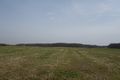
view to the east
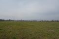
the west (Palatine forest in the background)
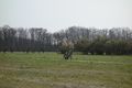
the north
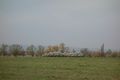
the south (bull in the background)

the hasher
the hasher
cherries are already in flower


Achievements
DODO earned the Land geohash achievement
|
DODO earned the Consecutive geohash achievement
|