Difference between revisions of "2016-04-04 42 -78"
imported>Pedalpusher (→Ribbons: updated categories) |
imported>Pedalpusher (updated summary, added pictures) |
||
| Line 10: | Line 10: | ||
In checking the hash for today I saw it was close to a county park I've never been to before. With the hash appearing to be on a road and easily accessible, I was willing to try. | In checking the hash for today I saw it was close to a county park I've never been to before. With the hash appearing to be on a road and easily accessible, I was willing to try. | ||
| − | After work I got the dogs ready and we had no trouble finding the mobile park. However this past weekend was cold and we got a fair amount of snow. The roads of the mobile park were not plowed and I couldn't tell where the road ended so I stayed in the existing paths of previous cars in order not to get stuck. | + | After work I got the dogs ready, and we drove by a couple previous hashes on our way. We had no trouble finding the mobile park. However this past weekend was cold and we got a fair amount of snow. The roads of the mobile park were not plowed and I couldn't tell where the road ended so I stayed in the existing paths of previous cars in order not to get stuck. |
| − | I tried staying in the car, but the GPS didn't have a good reading and said I still had about 90 feet/30 meters to go. So I turned around, found a spot to park for a minute and quickly walked to the hash. | + | I tried staying in the car, but the GPS didn't have a good reading and said I still had about 90 feet/30 meters to go. So I turned around, found a spot to park for a minute and quickly walked to the hash. Despite the satellite view showing the hash on or right next to the road, my gps led me to the grass next to a big yellow shed. |
Getting my pictures, I got back in the car and we drove to Hunter's creek county park where we walked around for over an hour on very soggy trails. The dogs at least enjoyed it. | Getting my pictures, I got back in the car and we drove to Hunter's creek county park where we walked around for over an hour on very soggy trails. The dogs at least enjoyed it. | ||
| + | |||
| + | On the way home, we followed the same route and passed right through the hash from [[2015-06-26 42 -78|2015-06-26]] at the intersection of Mill and Grover. | ||
Being in the town of Holland, I'm issuing a Tale of Two hashes challenge. | Being in the town of Holland, I'm issuing a Tale of Two hashes challenge. | ||
| Line 20: | Line 22: | ||
== Photos == | == Photos == | ||
<gallery perrow="5"> | <gallery perrow="5"> | ||
| − | Image: | + | Image: 2016-04-04 gps.jpg| Made it. I thought I got a picture of when it read 0.70 feet to go, but must have missed it. |
| − | Image: | + | Image: 2016-04-04 gps2.jpg| Accuracy. |
| − | Image: | + | Image: 2016-04-04 hashView.jpg | View of the hash. It is on the road side of the shed next to the far corner. |
| − | Image: | + | Image: 2016-04-04 stupidGrin.jpg | Standard stupid grin. |
| − | Image: | + | Image: 2016-04-04 hunterCreek.jpg | Where we went for a hike after. The trail map is a bit too big to read so I didn't include it here. |
| − | |||
| − | |||
| − | |||
</gallery> | </gallery> | ||
| Line 36: | Line 35: | ||
| date = 2016-04-04 | | date = 2016-04-04 | ||
}} | }} | ||
| + | {{A Tale of Two Hashes challenge | ||
| + | | latitude = 42 | ||
| + | | longitude = -78 | ||
| + | | date = 2016-04-04 | ||
| + | | name = Pedalpusher | ||
| + | | place = Holland | ||
| + | }} | ||
| − | |||
[[Category:Expeditions]] | [[Category:Expeditions]] | ||
[[Category:Coordinates reached]] | [[Category:Coordinates reached]] | ||
| − | + | [[Category:Expeditions with photos]] | |
Revision as of 12:26, 5 April 2016
| Mon 4 Apr 2016 in 42,-78: 42.6874627, -78.5129071 geohashing.info google osm bing/os kml crox |
Location
On a road of Hunter's Creek Mobile park in Holland, NY
Participants
Expedition
In checking the hash for today I saw it was close to a county park I've never been to before. With the hash appearing to be on a road and easily accessible, I was willing to try.
After work I got the dogs ready, and we drove by a couple previous hashes on our way. We had no trouble finding the mobile park. However this past weekend was cold and we got a fair amount of snow. The roads of the mobile park were not plowed and I couldn't tell where the road ended so I stayed in the existing paths of previous cars in order not to get stuck.
I tried staying in the car, but the GPS didn't have a good reading and said I still had about 90 feet/30 meters to go. So I turned around, found a spot to park for a minute and quickly walked to the hash. Despite the satellite view showing the hash on or right next to the road, my gps led me to the grass next to a big yellow shed.
Getting my pictures, I got back in the car and we drove to Hunter's creek county park where we walked around for over an hour on very soggy trails. The dogs at least enjoyed it.
On the way home, we followed the same route and passed right through the hash from 2015-06-26 at the intersection of Mill and Grover.
Being in the town of Holland, I'm issuing a Tale of Two hashes challenge.
Photos
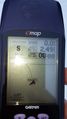
Made it. I thought I got a picture of when it read 0.70 feet to go, but must have missed it.
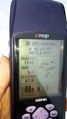
Accuracy.
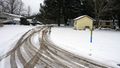
View of the hash. It is on the road side of the shed next to the far corner.

Standard stupid grin.
Where we went for a hike after. The trail map is a bit too big to read so I didn't include it here.


Ribbons
This user earned the Land geohash achievement
|
