Difference between revisions of "2016-04-04 56 -2"
From Geohashing
imported>Sourcerer m (→Fixed New report status) |
imported>FippeBot m (Location) |
||
| Line 47: | Line 47: | ||
[[Category:Expeditions with photos]] | [[Category:Expeditions with photos]] | ||
[[Category:Coordinates reached]] | [[Category:Coordinates reached]] | ||
| + | {{location|GB|SCT|FIF}} | ||
Latest revision as of 00:07, 16 August 2019
| Mon 4 Apr 2016 in 56,-2: 56.3055926, -2.8213584 geohashing.info google osm bing/os kml crox |
Location
A boggy field, south of St Andrews
Participants
Expedition
I hadn't checked the geohash location in months, and randomly decided to on this grey rainy day. 4km away. Great, that's so close I have to do it, otherwise Felix will never forgive me. The trip was straightforward. I rode out in the rain and cycled/walked through muddy and boggy fields. An excellent view of fog from the hashpoint. Returned in a loop, riding through as many puddles as possible to clean the mud off my bike.
Photos
Successful hash
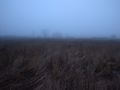
Scenic views

