Difference between revisions of "2016-04-12 42 -85"
imported>Mcbaneg (Created page with "<!-- If you did not specify these parameters in the template, please substitute appropriate values for IMAGE, LAT, LON, and DATE (YYYY-MM-DD format) {{{image|2016-04-12 42...") |
imported>FippeBot m (Location) |
||
| Line 51: | Line 51: | ||
[[Category:Expeditions with photos]] | [[Category:Expeditions with photos]] | ||
[[Category:Coordinates reached]] | [[Category:Coordinates reached]] | ||
| + | {{location|US|MI|KN}} | ||
Latest revision as of 00:11, 16 August 2019
| Tue 12 Apr 2016 in 42,-85: 42.8650575, -85.5309242 geohashing.info google osm bing/os kml crox |
Location
Beside the road in an industrial park, Cascade, MI
Participants
Expedition
This was easily accessible just off the road in the Meadowbrook commercial park south of the Grand Rapids airport. I was unable to get enthusiasm from the other family members so I did this one as a detour on the way home from work.
The hashpoint was on the side of a brushy, broad, V-shaped drainage ditch just to the south of a gravel road. My first attempt was on the south side of the ditch, but that turned out to be the wrong guess. There was a little water in the bottom and it was probably pretty soft near there so I walked around the head of the ditch and approached from the north, reaching the target easily and with clean dry feet.
Photos
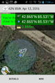
Proof.
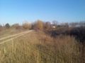
View to east along ditch, from a little north of hashpoint.
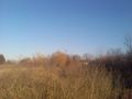
Similar view to east, from hashpoint itself.
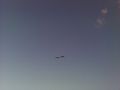
Northbound Canada geese that went by as I walked back toward the car.


