Difference between revisions of "2016-04-19 42 -85"
imported>Mcbaneg (Created page with "<!-- If you did not specify these parameters in the template, please substitute appropriate values for IMAGE, LAT, LON, and DATE (YYYY-MM-DD format) {{{image|2016-04-19 42...") |
imported>FippeBot m (Location) |
||
| Line 54: | Line 54: | ||
[[Category:Expeditions with photos]] | [[Category:Expeditions with photos]] | ||
[[Category:Coordinates reached]] | [[Category:Coordinates reached]] | ||
| + | {{location|US|MI|KN}} | ||
Latest revision as of 00:16, 16 August 2019
| Tue 19 Apr 2016 in 42,-85: 42.8721316, -85.5804811 geohashing.info google osm bing/os kml crox |
Location
Bank of Plaster Creek, Kentwood, MI
Participants
Expedition
Only about 5 miles from home, and apparently accessible: couldn't pass it up. It was bikeable but I was unable to leave home until 8 pm, and on the bike it would have been dark by the time I arrived, so I drove.
I was able to park in a pleasant neighborhood about 270 m from the hashpoint. The approach was to the west along a power-line right of way that was mostly grassy but in places swampy. When I needed to turn south through a clearing toward the hashpoint I found that its first 30 meters were one giant puddle. I was able to go a little further to the north and west to get around the puddle, and then go south through brush and rejoin the grassy clearing where it was dry. I saw a couple of whitetail deer run through the brush but was not fast enough to get a photo. The hashpoint was easy to reach a couple dozen meters above the creek.
On the way back I saw fresh deer tracks all over the place, including ones probably made by the deer I had seen.
Photos
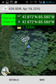
Proof.
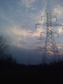
View to west, toward hashpoint, along powerline right-of-way.
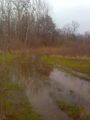
Originally planned route from powerline right-of-way to hashpoint: no go.
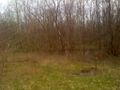
View south from hashpoint to Plaster Creek.

Grin.
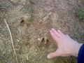
Deer tracks (smallish ones; hand in shot for scale).


