Difference between revisions of "2016-04-22 38 -77"
From Geohashing
imported>Mckaysalisbury (Adding photos shortly) |
imported>FippeBot m (Location) |
||
| (One intermediate revision by one other user not shown) | |||
| Line 31: | Line 31: | ||
== Photos == | == Photos == | ||
| − | |||
| − | |||
| − | |||
| − | |||
<gallery perrow="5"> | <gallery perrow="5"> | ||
| + | Image:2016-04-22_38_-77_Grin.jpg | Grin | ||
| + | Image:2016-04-22_38_-77_Son.jpg | Son | ||
| + | Image:2016-04-22_38_-77_Turtle.jpg | Turtle | ||
| + | Image:2016-04-22_38_-77_-_Tolerance.png | GPS screen before | ||
| + | Image:2016-04-22_38_-77_-_Close.png | GPS screen after | ||
</gallery> | </gallery> | ||
| Line 42: | Line 43: | ||
[[Category:Coordinates reached]] | [[Category:Coordinates reached]] | ||
| + | {{location|US|VA|FX}} | ||
Latest revision as of 01:47, 7 August 2019
| Fri 22 Apr 2016 in 38,-77: 38.8965632, -77.3597356 geohashing.info google osm bing/os kml crox |
Location
Difficult Run Stream Valley Trail Park
Participants
Plans
There's a road (Chipnowak Ct) that intersects the park about 500m from the point.
Expedition
We walked up the road it was marked as private, so we parked on Cobb Hill Lane, then walked there to the park.
Photos

Grin

Son
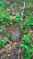
Turtle
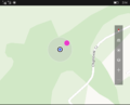
GPS screen before
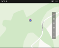
GPS screen after


