Difference between revisions of "2016-04-25 56 -2"
From Geohashing
imported>Talex ([live picture]View from the hash point) |
imported>FippeBot m (Location) |
||
| (3 intermediate revisions by one other user not shown) | |||
| Line 19: | Line 19: | ||
== Location == | == Location == | ||
| − | + | A farm track south of St Andrews | |
== Participants == | == Participants == | ||
| − | + | [[User:Talex|Talex]] ([[User talk:Talex|talk]]) | |
| − | |||
| − | |||
| − | |||
| − | |||
== Expedition == | == Expedition == | ||
| − | + | I rode there, enjoying tail winds. Took some quick photos. Rode home into the head winds. Thanks [[User talk:Felix_Dance|Felix]] | |
| − | |||
*Geohash success. -- [[User:Talex|Talex]] ([[User talk:Talex|talk]]) 20:19, 25 April 2016 (GMT+01:00) | *Geohash success. -- [[User:Talex|Talex]] ([[User talk:Talex|talk]]) 20:19, 25 April 2016 (GMT+01:00) | ||
| − | |||
| − | |||
== Photos == | == Photos == | ||
| Line 42: | Line 35: | ||
<gallery perrow="5"> | <gallery perrow="5"> | ||
| − | Image:2016-04-25_56_-2_talex_1461611987690.jpg| | + | Image:2016-04-25_56_-2_talex_1461611987690.jpg|GPS proof |
Image:2016-04-25_56_-2_talex_1461612111407.jpg|View from the hash point | Image:2016-04-25_56_-2_talex_1461612111407.jpg|View from the hash point | ||
| + | |||
| + | Image:2016-04-25_56_-2_talex_1461612122374.jpg|View the other way | ||
</gallery> | </gallery> | ||
| Line 51: | Line 46: | ||
<!-- Add any achievement ribbons you earned below, or remove this section --> | <!-- Add any achievement ribbons you earned below, or remove this section --> | ||
| − | |||
| − | |||
| − | |||
| − | |||
| − | |||
| − | |||
| − | |||
| − | |||
| − | |||
| − | |||
| − | |||
| − | |||
[[Category:Expeditions]] | [[Category:Expeditions]] | ||
| − | |||
[[Category:Expeditions with photos]] | [[Category:Expeditions with photos]] | ||
| − | |||
| − | |||
| − | |||
| − | |||
| − | |||
| − | |||
| − | + | [[Category:Coordinates reached]] | |
| − | [[Category:Coordinates | + | {{location|GB|SCT|FIF}} |
| − | |||
| − | |||
| − | |||
| − | |||
| − | |||
| − | |||
| − | |||
| − | |||
| − | |||
| − | |||
| − | |||
| − | |||
| − | |||
| − | |||
Latest revision as of 01:47, 7 August 2019
| Mon 25 Apr 2016 in 56,-2: 56.2682225, -2.7483724 geohashing.info google osm bing/os kml crox |
Location
A farm track south of St Andrews
Participants
Expedition
I rode there, enjoying tail winds. Took some quick photos. Rode home into the head winds. Thanks Felix
Photos
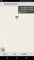
GPS proof
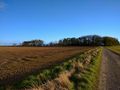
View from the hash point
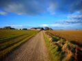
View the other way


