Difference between revisions of "2016-04-27 48 9"
imported>Drei aus Korb (An expedition message sent via Geohash Droid for Android.) |
m |
||
| (17 intermediate revisions by 4 users not shown) | |||
| Line 19: | Line 19: | ||
== Location == | == Location == | ||
| − | + | Ebersbach an der Fils, Germany | |
== Participants == | == Participants == | ||
| − | + | Holger / [[User:Drei aus Korb|Drei aus Korb]] | |
| − | |||
== Plans == | == Plans == | ||
| − | + | Knowing the place would not be very exciting I planned to get one or two geocaches plus an opencache on my way back home. | |
== Expedition == | == Expedition == | ||
| − | + | Ich hatte Zeit, also zog ich los, obgleich die verhältnismäßig lange Strecke kein besonders attraktives Ziel bot. | |
| + | Heute war es zudem fast schon winterlich kühl, der eisige Wind tat ein Übriges um ja keine Wohlfühlstimmung aufkommen zu lassen. | ||
| + | In der Tat war das Ziel inmitten eines kleinen Hochregallagers eines Baustoffhändlers; dennoch konnte ich mich einigermaßen annähern ohne Privatgrund zu verletzen. | ||
| − | + | Short summary in English: | |
| − | + | I had some time on my hands so I made my way to Endersbach an der Fils even though it was a cold, rainy day and the target didn't promise any excitement at all. I ended up on the rim of an industrial area locating the hashpoint in the center of a warehouse. | |
== Photos == | == Photos == | ||
| Line 39: | Line 40: | ||
--> | --> | ||
<gallery perrow="5"> | <gallery perrow="5"> | ||
| + | |||
| + | Image:2016-04-27_48_9_Drei aus Korb _1461747673157.jpg|Ebersbach an der Fils [http://www.openstreetmap.org/?lat=48.71786480&lon=9.53316410&zoom=16&layers=B000FTF @48.7179,9.5332] | ||
| + | File:Way.JPG | This way | ||
| + | File:Lager.JPG | Somewhere in there... | ||
| + | File:Screenshot_2016-04-27-10-59-25.png | Droid Screenshot | ||
</gallery> | </gallery> | ||
| − | |||
| − | |||
| − | |||
| − | |||
| − | |||
| − | |||
| − | |||
| − | |||
| − | |||
| − | |||
| − | |||
| − | |||
| − | |||
| − | |||
| − | |||
| − | |||
[[Category:Expeditions]] | [[Category:Expeditions]] | ||
| − | |||
[[Category:Expeditions with photos]] | [[Category:Expeditions with photos]] | ||
| − | |||
| − | |||
| − | |||
| − | |||
| − | |||
[[Category:Coordinates reached]] | [[Category:Coordinates reached]] | ||
| − | + | {{location|DE|BW|GP}} | |
| − | |||
| − | |||
| − | |||
| − | |||
| − | |||
| − | |||
| − | |||
| − | |||
| − | |||
| − | |||
| − | |||
| − | |||
| − | |||
| − | |||
| − | |||
| − | |||
| − | |||
Latest revision as of 06:47, 23 September 2021
| Wed 27 Apr 2016 in 48,9: 48.7179363, 9.5333387 geohashing.info google osm bing/os kml crox |
Location
Ebersbach an der Fils, Germany
Participants
Holger / Drei aus Korb
Plans
Knowing the place would not be very exciting I planned to get one or two geocaches plus an opencache on my way back home.
Expedition
Ich hatte Zeit, also zog ich los, obgleich die verhältnismäßig lange Strecke kein besonders attraktives Ziel bot. Heute war es zudem fast schon winterlich kühl, der eisige Wind tat ein Übriges um ja keine Wohlfühlstimmung aufkommen zu lassen. In der Tat war das Ziel inmitten eines kleinen Hochregallagers eines Baustoffhändlers; dennoch konnte ich mich einigermaßen annähern ohne Privatgrund zu verletzen.
Short summary in English: I had some time on my hands so I made my way to Endersbach an der Fils even though it was a cold, rainy day and the target didn't promise any excitement at all. I ended up on the rim of an industrial area locating the hashpoint in the center of a warehouse.
Photos
Ebersbach an der Fils @48.7179,9.5332
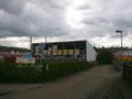
This way
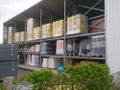
Somewhere in there...
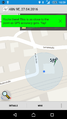
Droid Screenshot


