Difference between revisions of "2016-04-30 48 9"
From Geohashing
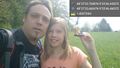
imported>Drei aus Korb ([live picture]Nürtingen Reudern [http://www.openstreetmap.org/?lat=48.62323900&lon=9.37957230&zoom=16&layers=B000FTF @48.6232,9.3796]) |
imported>Klaus (I'm out; fixed categories etc) |
||
| Line 1: | Line 1: | ||
| + | [[Image:{{{image|2016-04-30_48_9_Drei aus Korb _1462012585743.jpg}}}|thumb|left]] | ||
| − | |||
| − | |||
| − | |||
| − | |||
| − | |||
| − | |||
| − | |||
| − | |||
| − | |||
{{meetup graticule | {{meetup graticule | ||
| lat=48 | | lat=48 | ||
| Line 22: | Line 14: | ||
== Participants == | == Participants == | ||
| − | + | * [[User:Steingesicht|Steingesicht]] | |
| − | + | * [[User:Drei_aus_Korb|Drei aus Korb]] | |
== Plans == | == Plans == | ||
| − | + | *This looks like a hash I can reach today. | |
| + | Will try it in the afternoon. -- [[User:Steingesicht|Steingesicht]] ([[User talk:Steingesicht|talk]]) 08:23, 30 April 2016 (CEST) | ||
| + | * <s>Hm, now as you want to visit it, I'm thinking about going there, too. I've got some spare time over the day and it's an easy 30km/2h bicycle tour along the Neckar from Tübingen to Nürtingen (and I can take the train back, if I'm too lazy to cycle back)... When do you want to visit the geohash? --[[User:Klaus|Klaus]] ([[User talk:Klaus|talk]]) 08:37, 30 April 2016 (UTC)</s> I'm not hashing today, did some other stuff instead... --[[User:Klaus|Klaus]] ([[User talk:Klaus|talk]]) 13:13, 30 April 2016 (UTC) | ||
== Expedition == | == Expedition == | ||
| Line 32: | Line 26: | ||
| − | |||
| − | |||
| − | |||
== Tracklog == | == Tracklog == | ||
| Line 50: | Line 41: | ||
== Achievements == | == Achievements == | ||
{{#vardefine:ribbonwidth|800px}} | {{#vardefine:ribbonwidth|800px}} | ||
| − | |||
| − | |||
| − | |||
| − | |||
| − | |||
| − | |||
| − | |||
| − | |||
| − | |||
| − | |||
| − | |||
| − | |||
[[Category:Expeditions]] | [[Category:Expeditions]] | ||
| − | |||
[[Category:Expeditions with photos]] | [[Category:Expeditions with photos]] | ||
| − | |||
| − | |||
| − | |||
| − | |||
| − | |||
[[Category:Coordinates reached]] | [[Category:Coordinates reached]] | ||
| − | |||
| − | |||
| − | |||
| − | |||
| − | |||
| − | |||
| − | |||
| − | |||
| − | |||
| − | |||
| − | |||
| − | |||
| − | |||
| − | |||
| − | |||
| − | |||
| − | |||
| − | |||
Revision as of 13:13, 30 April 2016

| Sat 30 Apr 2016 in 48,9: 48.6232513, 9.3795681 geohashing.info google osm bing/os kml crox |
Location
small forest between Nürtingen and Reudern
Participants
Plans
- This looks like a hash I can reach today.
Will try it in the afternoon. -- Steingesicht (talk) 08:23, 30 April 2016 (CEST)
Hm, now as you want to visit it, I'm thinking about going there, too. I've got some spare time over the day and it's an easy 30km/2h bicycle tour along the Neckar from Tübingen to Nürtingen (and I can take the train back, if I'm too lazy to cycle back)... When do you want to visit the geohash? --Klaus (talk) 08:37, 30 April 2016 (UTC)I'm not hashing today, did some other stuff instead... --Klaus (talk) 13:13, 30 April 2016 (UTC)
Expedition
Tracklog
Photos
Nürtingen Reudern @48.6232,9.3796