Difference between revisions of "2016-04-30 48 9"
From Geohashing
imported>Drei aus Korb ([live picture]Nürtingen Reudern [http://www.openstreetmap.org/?lat=48.62323900&lon=9.37957230&zoom=16&layers=B000FTF @48.6232,9.3796]) |
m |
||
| (27 intermediate revisions by 4 users not shown) | |||
| Line 1: | Line 1: | ||
| + | [[Image:{{{image|2016-04-30_48_9_Drei aus Korb _1462012585743.jpg}}}|thumb|left]] | ||
| − | |||
| − | |||
| − | |||
| − | |||
| − | |||
| − | |||
| − | |||
| − | |||
| − | |||
{{meetup graticule | {{meetup graticule | ||
| lat=48 | | lat=48 | ||
| Line 22: | Line 14: | ||
== Participants == | == Participants == | ||
| − | + | * [[User:Steingesicht|Steingesicht]] | |
| − | + | * Mara & Holger / [[User:Drei_aus_Korb|Drei aus Korb]] | |
== Plans == | == Plans == | ||
| − | < | + | *This looks like a hash I can reach today. Will try it in the afternoon. -- [[User:Steingesicht|Steingesicht]] ([[User talk:Steingesicht|talk]]) 08:23, 30 April 2016 (CEST) |
| + | * <s>Hm, now as you want to visit it, I'm thinking about going there, too. I've got some spare time over the day and it's an easy 30km/2h bicycle tour along the Neckar from Tübingen to Nürtingen (and I can take the train back, if I'm too lazy to cycle back)... When do you want to visit the geohash? --[[User:Klaus|Klaus]] ([[User talk:Klaus|talk]]) 08:37, 30 April 2016 (UTC)</s> I'm not hashing today, did some other stuff instead... --[[User:Klaus|Klaus]] ([[User talk:Klaus|talk]]) 13:13, 30 April 2016 (UTC) | ||
| + | *Well, the weather was real fine and nothing else to do, my daughter and myself were planing to get to the hashpoint by car and do some geocaching as well.--[[User:Drei aus Korb|Drei aus Korb]] | ||
== Expedition == | == Expedition == | ||
| Line 32: | Line 26: | ||
| − | * | + | |
| − | + | ||
| − | * | + | *I went with my sons 10 km (one way) by bike to the hashpoint. The weather was perfect for the mission. At the point we took photos and found an abandoned geocache while exploring the surroundings. It could be OCC6A6 or OCC6A4. Unfortunately we did not met [[User:Drei_aus_Korb|Drei aus Korb]] - but they found two of my virtual caches at their way home :-) |
| + | -- [[User:Steingesicht|Steingesicht]] ([[User talk:Steingesicht|talk]]) [http://www.openstreetmap.org/?lat=48.62346800&lon=9.37945090&zoom=16&layers=B000FTF @48.6235,9.3795] 15:33, 30 April 2016 (CEST) | ||
| + | |||
| + | *We took the car at about 11:30 to take the trip to Reudern near Nürtingen. The weather was windy but quite fine and we reached a place to park the car at about 12:15, then we had a walk to the haspoint (about 700m). This time the surrounding was very nice; the spot was located at a meadow next to a little forest. As we reached the point we had the opportunity to watch a rabbit. Well, the "Gehash Droid" and/or my smartphone had problems with jumping coords; we didn't manage to get to zero even though there were no obstacles at all, in the consequence we too jumped around like the rabbit before to get some good result. | ||
| + | After we succeeded and after we had a picnic on a bench on our way to the car we did some geocaching in Reudern, than drove to Nürtingen and visited two spots (a graveyard and a roman ruin of some kind of a fort) of virtual geocaches from Opencaching.de. --[[User:Drei_aus_Korb|Drei aus Korb]] | ||
== Tracklog == | == Tracklog == | ||
| Line 45: | Line 43: | ||
<gallery perrow="5"> | <gallery perrow="5"> | ||
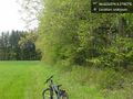
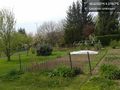
| − | Image:2016-04-30_48_9_Drei aus Korb _1462012585743.jpg|Nürtingen Reudern [http://www.openstreetmap.org/?lat=48.62323900&lon=9.37957230&zoom=16&layers=B000FTF @48.6232,9.3796] | + | Image:2016-04-30_48_9_Drei aus Korb _1462012585743.jpg|Drei aus Korb / Nürtingen Reudern [http://www.openstreetmap.org/?lat=48.62323900&lon=9.37957230&zoom=16&layers=B000FTF @48.6232,9.3796] |
| − | + | ||
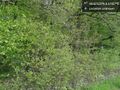
| + | File:Forest.JPG|A forest next to the hashpoint | ||
| + | |||
| + | File:Obstleerpfad.JPG|An Obstlehrpfad leads to the hashpoint | ||
| + | |||
| + | File:Kelter.JPG|nearby Kelter | ||
| + | |||
| + | File:6kmKirchheim.JPG|6 km to Kirchheim | ||
| + | |||
| + | Image:2016-04-30_48_9_steingesicht_1462029749414.jpg|The stupid grin | ||
| + | |||
| + | Image:2016-04-30_48_9_steingesicht_1462029815428.jpg|East view | ||
| + | |||
| + | Image:2016-04-30_48_9_steingesicht_1462029848069.jpg|South view | ||
| + | |||
| + | Image:2016-04-30_48_9_steingesicht_1462029881584.jpg|West view | ||
| − | + | Image:2016-04-30_48_9_steingesicht_1462029909532.jpg|North view | |
| − | |||
| − | |||
| − | + | Image:2016-04-30_48_9_steingesicht_1462029999425.jpg|View to the point from the near track. | |
| − | |||
| − | |||
| − | + | Image:2016-04-30_48_9_steingesicht_1462030038371.jpg|The wood | |
| − | |||
| − | |||
| − | |||
| − | + | Image:2016-04-30_48_9_steingesicht_1462030090741.jpg|Found an abandoned geocache nearby. | |
| − | + | Image:2016-04-30_48_9_steingesicht_1462030211189.jpg|Nearby allotment | |
| − | |||
| − | |||
| − | |||
| − | |||
| − | |||
| − | -- | ||
| − | |||
| − | |||
| − | |||
| + | Image:2016-04-30_48_9_steingesicht_1462030245033.jpg|Bike proof | ||
| − | + | Image:2016-04-30_48_9_steingesicht_1462030279566.jpg|Hash proof | |
| − | |||
| − | |||
| − | |||
| − | |||
| − | |||
| − | |||
| − | |||
| − | + | Image:2016-04-30_48_9_steingesicht_1462030331000.jpg|Albview | |
| − | + | </gallery> | |
| − | |||
| − | |||
| − | |||
| − | + | [[Category:Expeditions]] | |
| + | [[Category:Expeditions with photos]] | ||
| + | [[Category:Coordinates reached]] | ||
| + | {{location|DE|BW|ES}} | ||
Latest revision as of 06:48, 23 September 2021

| Sat 30 Apr 2016 in 48,9: 48.6232513, 9.3795681 geohashing.info google osm bing/os kml crox |
Location
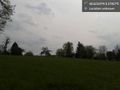
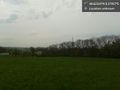
small forest between Nürtingen and Reudern
Participants
- Steingesicht
- Mara & Holger / Drei aus Korb
Plans
- This looks like a hash I can reach today. Will try it in the afternoon. -- Steingesicht (talk) 08:23, 30 April 2016 (CEST)
Hm, now as you want to visit it, I'm thinking about going there, too. I've got some spare time over the day and it's an easy 30km/2h bicycle tour along the Neckar from Tübingen to Nürtingen (and I can take the train back, if I'm too lazy to cycle back)... When do you want to visit the geohash? --Klaus (talk) 08:37, 30 April 2016 (UTC)I'm not hashing today, did some other stuff instead... --Klaus (talk) 13:13, 30 April 2016 (UTC)- Well, the weather was real fine and nothing else to do, my daughter and myself were planing to get to the hashpoint by car and do some geocaching as well.--Drei aus Korb
Expedition
- I went with my sons 10 km (one way) by bike to the hashpoint. The weather was perfect for the mission. At the point we took photos and found an abandoned geocache while exploring the surroundings. It could be OCC6A6 or OCC6A4. Unfortunately we did not met Drei aus Korb - but they found two of my virtual caches at their way home :-)
-- Steingesicht (talk) @48.6235,9.3795 15:33, 30 April 2016 (CEST)
- We took the car at about 11:30 to take the trip to Reudern near Nürtingen. The weather was windy but quite fine and we reached a place to park the car at about 12:15, then we had a walk to the haspoint (about 700m). This time the surrounding was very nice; the spot was located at a meadow next to a little forest. As we reached the point we had the opportunity to watch a rabbit. Well, the "Gehash Droid" and/or my smartphone had problems with jumping coords; we didn't manage to get to zero even though there were no obstacles at all, in the consequence we too jumped around like the rabbit before to get some good result.
After we succeeded and after we had a picnic on a bench on our way to the car we did some geocaching in Reudern, than drove to Nürtingen and visited two spots (a graveyard and a roman ruin of some kind of a fort) of virtual geocaches from Opencaching.de. --Drei aus Korb
Tracklog
Photos
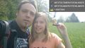
Drei aus Korb / Nürtingen Reudern @48.6232,9.3796
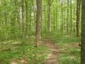
A forest next to the hashpoint
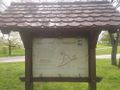
An Obstlehrpfad leads to the hashpoint
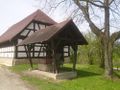
nearby Kelter
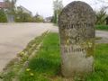
6 km to Kirchheim

The stupid grin
East view
South view
West view
North view
View to the point from the near track.
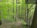
The wood
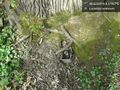
Found an abandoned geocache nearby.
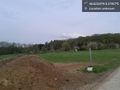
Nearby allotment
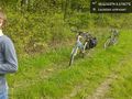
Bike proof
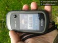
Hash proof
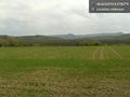
Albview


