Difference between revisions of "2016-05-12 52 1"
From Geohashing
imported>Sourcerer m ([live] Arrived.) |
imported>Sourcerer m ([live picture] Now midnight. [http://www.openstreetmap.org/?lat=52.43058264&lon=1.33759618&zoom=16&layers=B000FTF @52.4306,1.3376]) |
||
| Line 27: | Line 27: | ||
<gallery perrow="5"> | <gallery perrow="5"> | ||
| + | |||
| + | Image:2016-05-12_52_1_Sourcerer_1463007243139.jpg | Now midnight. [http://www.openstreetmap.org/?lat=52.43058264&lon=1.33759618&zoom=16&layers=B000FTF @52.4306,1.3376] | ||
</gallery> | </gallery> | ||
Revision as of 23:00, 11 May 2016
| Thu 12 May 2016 in Norwich, UK: 52.4305283, 1.3376619 geohashing.info google osm bing/os kml crox |
Location
A field between Piccadilly Corner and Alburgh, Norfolk, UK.
Participants
Plans
Two of two spanning midnight - 2016-05-11 52 1 - 2016-05-12 52 1 - ETA 00:00.
Expedition
- Arrived. -- Sourcerer (talk) @52.4306,1.3376 23:56, 11 May 2016 (GMT+01:00)
Photos
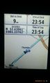
Now midnight. @52.4306,1.3376

Achievements
Expeditions and Plans
| 2016-05-12 | ||
|---|---|---|
| Norwich, United Kingdom | Sourcerer | A field between Piccadilly Corner and Alburgh, Norfolk, UK. |
| Turku, Finland | Suurnesu | In front of some private houses near Lauste in Turku |
Sourcerer's Expedition Links
2016-05-11 52 1 - 2016-05-12 52 1 - 2016-05-13 52 1 - KML file download of Sourcerer's expeditions for use with Google Earth.