Difference between revisions of "2016-05-13 34 -118"
From Geohashing
imported>Bravissimo594 m ([live picture]Success! [http://www.openstreetmap.org/?lat=34.14052350&lon=-118.12587880&zoom=16&layers=B000FTF @34.1405,-118.1259]) |
imported>FippeBot m (Location) |
||
| (3 intermediate revisions by one other user not shown) | |||
| Line 25: | Line 25: | ||
<!-- who attended: If you link to your wiki user name in this section, your expedition will be picked up by the various statistics generated for geohashing. You may use three tildes ~ as a shortcut to automatically insert the user signature of the account you are editing with. | <!-- who attended: If you link to your wiki user name in this section, your expedition will be picked up by the various statistics generated for geohashing. You may use three tildes ~ as a shortcut to automatically insert the user signature of the account you are editing with. | ||
--> | --> | ||
| + | [[User:Bravissimo594|Bravissimo594]] ([[User talk:Bravissimo594|talk]]) | ||
== Plans == | == Plans == | ||
| Line 32: | Line 33: | ||
== Expedition == | == Expedition == | ||
<!-- how it all turned out. your narrative goes here. --> | <!-- how it all turned out. your narrative goes here. --> | ||
| + | I made it there at about 4:20pm, took some pictures, and left a poster in place. Stuck around until about 4:30pm. [[User:Bravissimo594|Bravissimo594]] ([[User talk:Bravissimo594|talk]]) | ||
| − | == Tracklog == | + | <!-- == Tracklog == |
| − | + | if your GPS device keeps a log, you may post a link here --> | |
== Photos == | == Photos == | ||
| Line 43: | Line 45: | ||
Image:2016-05-13_34_-118_Bravissimo594_1463182109357.jpg|Success! [http://www.openstreetmap.org/?lat=34.14052350&lon=-118.12587880&zoom=16&layers=B000FTF @34.1405,-118.1259] | Image:2016-05-13_34_-118_Bravissimo594_1463182109357.jpg|Success! [http://www.openstreetmap.org/?lat=34.14052350&lon=-118.12587880&zoom=16&layers=B000FTF @34.1405,-118.1259] | ||
| + | |||
| + | Image:2016-05-13_34_-118_Bravissimo594_1463182154656.jpg|Geohash Droid screen. | ||
| + | |||
| + | Image:2016-05-13_34_-118_Bravissimo594_1463182199328.jpg|Marker left in place. [http://www.openstreetmap.org/?lat=34.14053450&lon=-118.12583410&zoom=16&layers=B000FTF @34.1405,-118.1258] | ||
</gallery> | </gallery> | ||
| Line 51: | Line 57: | ||
<!-- =============== USEFUL CATEGORIES FOLLOW ================ | <!-- =============== USEFUL CATEGORIES FOLLOW ================ | ||
Delete the next line ONLY if you have chosen the appropriate categories below. If you are unsure, don't worry. People will read your report and help you with the classification. --> | Delete the next line ONLY if you have chosen the appropriate categories below. If you are unsure, don't worry. People will read your report and help you with the classification. --> | ||
| − | [[Category:New report]] | + | <!-- [[Category:New report]] --> |
<!-- Potential categories. Please include all the ones appropriate to your expedition --> | <!-- Potential categories. Please include all the ones appropriate to your expedition --> | ||
| − | <!-- If this is a planning page: | + | <!-- If this is a planning page: |
| − | [[Category:Expedition planning]] | + | [[Category:Expedition planning]] --> |
<!-- If all those plans are never acted upon, change [[Category:Expedition planning]] to [[Category:Not reached - Did not attempt]]. --> | <!-- If all those plans are never acted upon, change [[Category:Expedition planning]] to [[Category:Not reached - Did not attempt]]. --> | ||
| − | <!-- An actual expedition: | + | <!-- An actual expedition: --> |
[[Category:Expeditions]] | [[Category:Expeditions]] | ||
| − | |||
[[Category:Expeditions with photos]] | [[Category:Expeditions with photos]] | ||
| − | [[Category:Expeditions with videos]] | + | <!-- [[Category:Expeditions with videos]] --> |
| − | [[Category:Expedition without GPS]] | + | <!-- [[Category:Expedition without GPS]] --> |
| − | --> | + | |
| − | <!-- if you reached your coords: | + | <!-- if you reached your coords: --> |
[[Category:Coordinates reached]] | [[Category:Coordinates reached]] | ||
| − | + | <!-- or if you failed :( | |
| − | |||
| − | |||
[[Category:Coordinates not reached]] | [[Category:Coordinates not reached]] | ||
-- and a reason -- | -- and a reason -- | ||
| Line 87: | Line 90: | ||
(Don't forget to delete this final close comment marker) --> | (Don't forget to delete this final close comment marker) --> | ||
| + | {{location|US|CA|LO}} | ||
Latest revision as of 00:30, 16 August 2019
| Fri 13 May 2016 in 34,-118: 34.1405096, -118.1258892 geohashing.info google osm bing/os kml crox |
Location
Beside a Michigan Ave. sidewalk on the campus of Caltech in Pasadena.
Participants
Plans
Bravissimo594 (talk) plans to make it to the hashpoint sometime between 4:30pm and 8:30pm.
Expedition
I made it there at about 4:20pm, took some pictures, and left a poster in place. Stuck around until about 4:30pm. Bravissimo594 (talk)
Photos
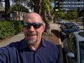
Success! @34.1405,-118.1259
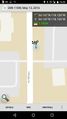
Geohash Droid screen.
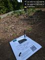
Marker left in place. @34.1405,-118.1258


