Difference between revisions of "2016-05-14 52 1"
From Geohashing
imported>Sourcerer (→Planning) |
imported>Sourcerer m ([live picture] Arrival. [http://www.openstreetmap.org/?lat=52.19133496&lon=1.57564759&zoom=16&layers=B000FTF @52.1913,1.5756]) |
||
| Line 26: | Line 26: | ||
<gallery perrow="5"> | <gallery perrow="5"> | ||
| + | |||
| + | Image:2016-05-14_52_1_Sourcerer_1463180908844.jpg | Arrival. [http://www.openstreetmap.org/?lat=52.19133496&lon=1.57564759&zoom=16&layers=B000FTF @52.1913,1.5756] | ||
</gallery> | </gallery> | ||
Revision as of 23:10, 13 May 2016
| Sat 14 May 2016 in Norwich, UK: 52.1913067, 1.5756310 geohashing.info google osm bing/os kml crox |
Location
A field south of Aldringham, Suffolk, UK.
Participants
Plans
Two of two spanning midnight - 2016-05-13 51 1 - 2016-05-14 52 1 - ETA 00:00.
Expedition
Photos
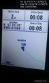
Arrival. @52.1913,1.5756

Achievements
Expeditions and Plans
| 2016-05-14 | ||
|---|---|---|
| Sacramento, California | gldminer | Somewhere |
| Norwich, United Kingdom | Sourcerer | A field south of Aldringham, Suffolk, UK. |
Sourcerer's Expedition Links
2016-05-13 51 1 - 2016-05-14 52 1 - 2016-05-15 52 1 - KML file download of Sourcerer's expeditions for use with Google Earth.