Difference between revisions of "2016-05-21 49 8"
imported>DODO (→Expedition) |
imported>FippeBot m (Location) |
||
| (3 intermediate revisions by 2 users not shown) | |||
| Line 1: | Line 1: | ||
| + | [[Image:{{{image|2016-04-21_49_8-01.jpg}}}|thumb|left]] | ||
| − | |||
| − | |||
| − | |||
| − | |||
| − | |||
| − | |||
| − | |||
| − | |||
| − | |||
{{meetup graticule | {{meetup graticule | ||
| lat=49 | | lat=49 | ||
| Line 25: | Line 17: | ||
* [[User:DLichti|DLichti]] | * [[User:DLichti|DLichti]] | ||
* a friend | * a friend | ||
| + | * a sister | ||
* [[User:DODO|DODO]] | * [[User:DODO|DODO]] | ||
| − | |||
== Plans == | == Plans == | ||
| Line 42: | Line 34: | ||
I had to be back home at 5 pm and so I had to catch the train at 16:08 in Karlsruhe. I started riding at 1 pm and had a very pleasant ride. The weather was sunny and warm with a slight wind mostly coming from the front. At 3 pm I reached the hash forest and some minutes later I parked the bull on a forest path and started searching for the exact point. I got a shot under 2m but I don't know, how reliable this value is in the thick forest. Took some pictures and left again, unfortunately an hour early. Would have been fun to meet the others. Then I continued my ride through the Kraichgau down to Karlsruhe, and reached the station at 15:45. Plenty of time to catch the train. | I had to be back home at 5 pm and so I had to catch the train at 16:08 in Karlsruhe. I started riding at 1 pm and had a very pleasant ride. The weather was sunny and warm with a slight wind mostly coming from the front. At 3 pm I reached the hash forest and some minutes later I parked the bull on a forest path and started searching for the exact point. I got a shot under 2m but I don't know, how reliable this value is in the thick forest. Took some pictures and left again, unfortunately an hour early. Would have been fun to meet the others. Then I continued my ride through the Kraichgau down to Karlsruhe, and reached the station at 15:45. Plenty of time to catch the train. | ||
| + | |||
| + | [[User:DLichti|DLichti]] | ||
| + | |||
| + | I left at around 12:30 to take the train to Karlsruhe. My sister decided in the last minute to come along. The previous train had been late and eventually cancelled, so our train was also delayed and very crowded. Fortunately, we had enough time to catch our next train in Karlsruhe. We met my friend just outside Karlsruhe Main station. I checked the wiki-page one last time and then we took our train to Jöhlingen. | ||
| + | |||
| + | We arrived in Jöhlingen at around 14:30 and started walking to the hashpoint. After 3km, we came by a forest class room. But since it was saturday, no class took place at that moment. Nevertheless, we used the counting trainer (consisting of a tree cross section with annual rings) for some counting exercise: the solution is ~70 years. There was a model flight airfield where we admired some stunts by an rc helicopter. | ||
| + | |||
| + | Since it was getting late, we hurried a bit to reach the hashpoint in time. We arrived at around 15:50. My GPS wasn't working very well either, but I found two or three spots where my phone showed very little error and small distance, one of them was probably the right location. Now that I read DODOs report, I remember seeing some branches on the ground. Unfortunately, I didn't take any closer look, so there are no other pictures of the sign, sorry for that. | ||
| + | |||
| + | After 30 minutes and some snacks, we continued on our way to Rinklingen where we arrived at around 17:25. We took the next train to Karlsruhe. There, my friend left us while my sister and I continued on our way home. At 19:15, we were back. | ||
== Photos == | == Photos == | ||
| Line 47: | Line 49: | ||
Image:2012-##-## ## ## Alpha.jpg | Witty Comment | Image:2012-##-## ## ## Alpha.jpg | Witty Comment | ||
--> | --> | ||
| + | === DODOs photos === | ||
<gallery perrow="5"> | <gallery perrow="5"> | ||
| + | Image:2016-04-21 49 8-00.jpg|proof of transport: my bull | ||
| + | Image:2016-04-21 49 8-01.jpg|a stand near the hashpoint | ||
| + | Image:2016-04-21 49 8-02.jpg|the path | ||
| + | Image:2016-04-21 49 8-03.jpg|the hasher unfortunately lying :-( | ||
| + | Image:2016-04-21 49 8-04.jpg|another path leaves the main path near the hash | ||
| + | Image:2016-04-21 49 8-05.jpg|I left a mark and hope to see some more pictures of that from other hashers | ||
| + | Image:2016-04-21 49 8-06.jpg|a lot of woodruff grew at the point (but you shouldn't collect, when it's already in flower) | ||
| + | Image:2016-05-21 49 8-07.png|proof | ||
| + | </gallery> | ||
| + | |||
| + | === DLichti === | ||
| + | <gallery perrow="5"> | ||
| + | Image:2016-05-21_49_8_DLichti_Walzbachtal.jpg|Panoramic view of the fields | ||
| + | Image:2016-05-21 49 8 DLichti old tree.jpg|How old's that tree? - Probably something like 70 years. | ||
| + | Image:2016-05-21_49_8_DLichti_RC_chopper.jpg|An RC helicopter flying quite impressive stunts | ||
| + | Image:2016-05-21_49_8_DLichti_forest_track.jpg|the path, opposite direction | ||
| + | Image:2016-05-21_49_8_DLichti_hashpoint.jpg|the hashpoint is probably somewhere there | ||
| + | Image:2016-05-21_49_8_DLichti_proof.png|(potential) proof | ||
</gallery> | </gallery> | ||
| Line 54: | Line 75: | ||
<!-- Add any achievement ribbons you earned below, or remove this section --> | <!-- Add any achievement ribbons you earned below, or remove this section --> | ||
| − | + | {{land geohash | |
| − | + | | latitude = 49 | |
| − | + | | longitude = 8 | |
| + | | date = 2016-05-21 | ||
| + | | name = DODO | ||
| + | }} | ||
| − | + | I'm really ashamed but I didn't realize that it's geohashing day until I saw the big number of expeditions today. So there's another shiny ribbon (and I celebrate at home with some asparagus and a good bottle of wine). | |
| − | + | {{Geohashing Day | |
| − | + | | latitude = 49 | |
| + | | longitude = 8 | ||
| + | | year = 2016 | ||
| + | | coorddate = 2016-05-21 | ||
| + | | name = DODO | ||
| + | }} | ||
| − | |||
[[Category:Expeditions]] | [[Category:Expeditions]] | ||
| − | |||
[[Category:Expeditions with photos]] | [[Category:Expeditions with photos]] | ||
| − | |||
| − | |||
| − | |||
| − | |||
| − | |||
[[Category:Coordinates reached]] | [[Category:Coordinates reached]] | ||
| − | + | {{location|DE|BW|KA}} | |
| − | |||
| − | |||
| − | |||
| − | |||
| − | |||
| − | |||
| − | |||
| − | |||
| − | |||
| − | |||
| − | |||
| − | |||
| − | |||
| − | |||
| − | |||
| − | |||
| − | |||
Latest revision as of 00:35, 16 August 2019

| Sat 21 May 2016 in 49,8: 49.0365641, 8.6168378 geohashing.info google osm bing/os kml crox |
Location
In the forest near Walzbachtal
Participants
Plans
Take the S4 at 13:55 from Karlsruhe Main station to arrive in Jöhlingen at 14:27. Explore the area and try to be at the HP at 16:00. Go back.
Ride to the hp by bull.
Expedition
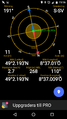
I had to be back home at 5 pm and so I had to catch the train at 16:08 in Karlsruhe. I started riding at 1 pm and had a very pleasant ride. The weather was sunny and warm with a slight wind mostly coming from the front. At 3 pm I reached the hash forest and some minutes later I parked the bull on a forest path and started searching for the exact point. I got a shot under 2m but I don't know, how reliable this value is in the thick forest. Took some pictures and left again, unfortunately an hour early. Would have been fun to meet the others. Then I continued my ride through the Kraichgau down to Karlsruhe, and reached the station at 15:45. Plenty of time to catch the train.
I left at around 12:30 to take the train to Karlsruhe. My sister decided in the last minute to come along. The previous train had been late and eventually cancelled, so our train was also delayed and very crowded. Fortunately, we had enough time to catch our next train in Karlsruhe. We met my friend just outside Karlsruhe Main station. I checked the wiki-page one last time and then we took our train to Jöhlingen.
We arrived in Jöhlingen at around 14:30 and started walking to the hashpoint. After 3km, we came by a forest class room. But since it was saturday, no class took place at that moment. Nevertheless, we used the counting trainer (consisting of a tree cross section with annual rings) for some counting exercise: the solution is ~70 years. There was a model flight airfield where we admired some stunts by an rc helicopter.
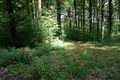
Since it was getting late, we hurried a bit to reach the hashpoint in time. We arrived at around 15:50. My GPS wasn't working very well either, but I found two or three spots where my phone showed very little error and small distance, one of them was probably the right location. Now that I read DODOs report, I remember seeing some branches on the ground. Unfortunately, I didn't take any closer look, so there are no other pictures of the sign, sorry for that.
After 30 minutes and some snacks, we continued on our way to Rinklingen where we arrived at around 17:25. We took the next train to Karlsruhe. There, my friend left us while my sister and I continued on our way home. At 19:15, we were back.
Photos
DODOs photos
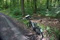
proof of transport: my bull
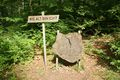
a stand near the hashpoint
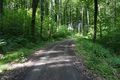
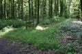
the path
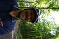
the hasher unfortunately lying :-(
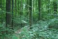
another path leaves the main path near the hash
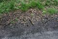
I left a mark and hope to see some more pictures of that from other hashers
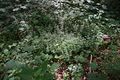
a lot of woodruff grew at the point (but you shouldn't collect, when it's already in flower)
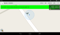
proof


DLichti
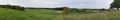
Panoramic view of the fields
How old's that tree? - Probably something like 70 years.

An RC helicopter flying quite impressive stunts
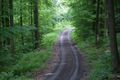
the path, opposite direction
the hashpoint is probably somewhere there
(potential) proof


Achievements
DODO earned the Land geohash achievement
|
I'm really ashamed but I didn't realize that it's geohashing day until I saw the big number of expeditions today. So there's another shiny ribbon (and I celebrate at home with some asparagus and a good bottle of wine).
DODO earned the 2016 Geohashing Day achievement
|