Difference between revisions of "2016-05-24 42 -78"
imported>Pedalpusher (new expedition report) |
imported>Pedalpusher (summary, pictures) |
||
| Line 8: | Line 8: | ||
== Expedition == | == Expedition == | ||
| + | After work, I went to a board meeting for a camp where I volunteer. We had a simple dinner of pizza and salad while we had our meeting for the month. Getting done there around 18:30, I drove into the city which wasn't much of a detour on the way home. | ||
| + | |||
| + | I was able to find a parking spot on the eastern side of Delaware Ave very close to the intersection. Hopping out, I walked up and crossed Delaware and estimated that the hash should be right about on the man-hole cover in the middle of W. Ferry behind the stop line for the intersection. While I waited to cross the street, I took a picture. Crossing with the light, I got a picture from the other side along with the street signs. | ||
| + | |||
| + | I was pleasantly surprised that the stupid grin picture came out so nice especially with the sun shining right down the middle of the street on it's way to setting. Glad I didn't have to cross the street again(I tried to take it as I was walking so not to block cars trying to turn), I walked back to the car and headed for home. | ||
== Photos == | == Photos == | ||
<gallery perrow="5"> | <gallery perrow="5"> | ||
| − | Image: | + | Image: 2016 05-24 satelliteView.jpg | The hash is about half a car length behind the Stop Line in the intersection. |
| − | Image: | + | Image: 2016 05-24 hashViewN.jpg | Waiting for the light to change so I could cross through the hash point. |
| − | Image: | + | Image: 2016 05-24 intersection.jpg | Walked through the hash point to get a picture of the street signs. |
| − | Image: | + | Image: 2016 05-24 hashViewS.jpg | On the other side, waiting again for the light. It should just about be on the man-hole cover. |
| − | Image: | + | Image: 2016 05-24 stupidGrin.jpg | Walking back through with the sun setting in the background. |
| − | |||
| − | |||
| − | |||
</gallery> | </gallery> | ||
| Line 34: | Line 36: | ||
}} | }} | ||
| − | |||
[[Category:Expeditions]] | [[Category:Expeditions]] | ||
[[Category:Coordinates reached]] | [[Category:Coordinates reached]] | ||
| − | + | [[Category:Expeditions with photos]] | |
Revision as of 22:02, 1 June 2016
| Tue 24 May 2016 in 42,-78: 42.9153930, -78.8693746 geohashing.info google osm bing/os kml crox |
Location
Middle of W. Ferry St at the intersection of Delaware Ave in Buffalo
Participants
Expedition
After work, I went to a board meeting for a camp where I volunteer. We had a simple dinner of pizza and salad while we had our meeting for the month. Getting done there around 18:30, I drove into the city which wasn't much of a detour on the way home.
I was able to find a parking spot on the eastern side of Delaware Ave very close to the intersection. Hopping out, I walked up and crossed Delaware and estimated that the hash should be right about on the man-hole cover in the middle of W. Ferry behind the stop line for the intersection. While I waited to cross the street, I took a picture. Crossing with the light, I got a picture from the other side along with the street signs.
I was pleasantly surprised that the stupid grin picture came out so nice especially with the sun shining right down the middle of the street on it's way to setting. Glad I didn't have to cross the street again(I tried to take it as I was walking so not to block cars trying to turn), I walked back to the car and headed for home.
Photos
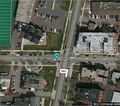
The hash is about half a car length behind the Stop Line in the intersection.
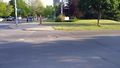
Waiting for the light to change so I could cross through the hash point.
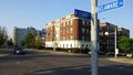
Walked through the hash point to get a picture of the street signs.
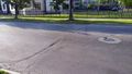
On the other side, waiting again for the light. It should just about be on the man-hole cover.
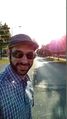
Walking back through with the sun setting in the background.


Ribbons
This user earned the Land geohash achievement
|
Pedalpusher earned the No Batteries Geohash Achievement
|