Difference between revisions of "2016-05-26 52 4"
imported>FelixTheCat m |
imported>FippeBot m (Location) |
||
| (3 intermediate revisions by one other user not shown) | |||
| Line 13: | Line 13: | ||
== Plans == | == Plans == | ||
| − | This hash came up nearby and it appeared to be reachable. So I planned go by bike after work. | + | This hash came up nearby and it appeared to be reachable. So I planned to go by bike after work. |
== Expedition == | == Expedition == | ||
| − | The weather was nice (sunny, 20 °C), and I set off around 16:45. The location was pretty easy to reach, in the city of Rijswijk (between The Hague and Delft), wedged between a residential area and a couple of sports fields. When I reached the location however, I discovered that there was a ditch between the fields, and the hash turned out to be right in the middle! OpenStreetMap didn't show any water there, and it wasn't visible on satellite view either. | + | The weather was nice (sunny, 20 °C), and I set off around 16:45. The location was pretty easy to reach, in the city of Rijswijk (between The Hague and Delft), wedged between a residential area and a couple of sports fields. When I reached the location however, I discovered that there was a ditch between the fields, and the hash turned out to be right in the middle! OpenStreetMap didn't show any water there, and it wasn't visible on satellite view either. I didn't dare to venture near the edge like I did on [[2015-10-09 52 4]], because the bank was very steep and overgrown with weeds. My Kingdom for a Boat! Though I guess a pair of Wellingtons would do, too :-) |
| + | |||
| + | I later updated OpenStreetMap to include the ditch, and thereby achieved the OpenStreetMap ribbon. | ||
== Photos == | == Photos == | ||
| Line 35: | Line 37: | ||
| waterhazard = ditch | | waterhazard = ditch | ||
| + | }} | ||
| + | {{OpenStreetMap achievement | ||
| + | |||
| + | | latitude = 52 | ||
| + | | longitude = 4 | ||
| + | | date = 2016-05-26 | ||
| + | | OSMlink = https://www.openstreetmap.org/changeset/39598436 | ||
| + | | name = [[User:FelixTheCat|FelixTheCat]] ([[User talk:FelixTheCat|talk]]) | ||
}} | }} | ||
| Line 41: | Line 51: | ||
[[Category:Coordinates not reached]] | [[Category:Coordinates not reached]] | ||
[[Category:Not reached - Mother Nature]] | [[Category:Not reached - Mother Nature]] | ||
| + | {{location|NL|ZH}} | ||
Latest revision as of 00:37, 16 August 2019
| Thu 26 May 2016 in 52,4: 52.0408970, 4.2956386 geohashing.info google osm bing/os kml crox |
Location
Near some sports fields in Rijswijk, ZH.
Participants
Plans
This hash came up nearby and it appeared to be reachable. So I planned to go by bike after work.
Expedition
The weather was nice (sunny, 20 °C), and I set off around 16:45. The location was pretty easy to reach, in the city of Rijswijk (between The Hague and Delft), wedged between a residential area and a couple of sports fields. When I reached the location however, I discovered that there was a ditch between the fields, and the hash turned out to be right in the middle! OpenStreetMap didn't show any water there, and it wasn't visible on satellite view either. I didn't dare to venture near the edge like I did on 2015-10-09 52 4, because the bank was very steep and overgrown with weeds. My Kingdom for a Boat! Though I guess a pair of Wellingtons would do, too :-)
I later updated OpenStreetMap to include the ditch, and thereby achieved the OpenStreetMap ribbon.
Photos
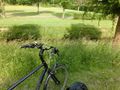
My bike near the hash.
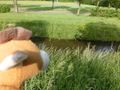
Lloyd looking at the ditch.
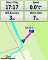
Close, but not close enough!


Achievements
FelixTheCat (talk) earned the My kingdom for a boat consolation prize
|
FelixTheCat (talk) earned the OpenStreetMap achievement
|