Difference between revisions of "2016-05-30 39 -76"
imported>Djaquay (→Photos) |
imported>Djaquay (→Participants) |
||
| Line 22: | Line 22: | ||
== Participants == | == Participants == | ||
| − | [[User:Djaquay|Djaquay]] ([[User talk:Djaquay|talk]]), wife, and daughter. | + | [[User:Djaquay|Djaquay]] ([[User talk:Djaquay|talk]]), wife, and daughter (who insisted on no photos). |
== Plans == | == Plans == | ||
Revision as of 01:01, 31 May 2016
| Mon 30 May 2016 in 39,-76: 39.1077141, -76.5989759 geohashing.info google osm bing/os kml crox |
Location
In Elvaton Park, south of Glen Burnie (outskirts of Baltimore, MD).
Participants
Djaquay (talk), wife, and daughter (who insisted on no photos).
Plans
Expedition
We started out aiming to head for the hashpoint, then go get something to eat down in Annapolis. But as the hashpoint was 80mi/125km away, direct, by the time we got down there, everybody (else) was getting hungry, so we hit Annapolis first. Ate at the apparently world famous (or at least "as seen on TV") Chick 'n Ruth's Delly (sic); had a couple of beers and a delicious omelet, took a tour of town, walked around a bit, and grabbed some ice cream.
And then headed for the hashpoint. Park was pretty well deserted by the time we got there, a little after 6pm. Rain, which had been forcasted, held off until after we left, but it was starting to look gloomy. Fortunately, the point was conveniently just off a path, at the edge of a patch of light woods, maybe 100m from the parking lot.
Photos
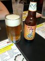
The beer, at the diner.

Touring Annapolis, prior to hashpoint quest.
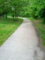
The trail to the hashpoint.
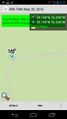
The proof.


Achievements