2016-06-05 48 7
From Geohashing
Revision as of 11:56, 5 June 2016 by imported>Hijackal ([live picture]Yay! Now we just need to get back home before that thunderstorm gets here... [http://www.openstreetmap.org/?lat=48.03102360&lon=7.92524330&zoom=16&layers=B000FTF @48.0310,7.9252])
| Sun 5 Jun 2016 in 48,7: 48.0308000, 7.9252089 geohashing.info google osm bing/os kml crox |
Location
A field in the Föhrental, probably steep and used by cows.
Participants
Plans
Frizzy and Hijackal see that this one is about 5 km from their home and decide to go for it. Five minutes later, some friends call to say that the weather does not seem suitable for climbing. Being that sort of family, they are quickly convinced to go on "eine völlig sinnlose Wanderung" - a completely pointless hike.
Since there are some 500 m of altitude between us and the hash, the 5 km might take a while. If anyone is spontaneous, our ETA is about 13:15.
Expedition
Tracklog
Photos
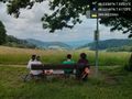
A nice break with some food... It's all downhill from here! @48.0315,7.9172
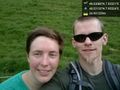
Yay! Now we just need to get back home before that thunderstorm gets here... @48.0310,7.9252


Achievements