Difference between revisions of "2016-06-18 33 -118"
From Geohashing
imported>Mckaysalisbury (Plans in place) |
imported>FippeBot m (Location) |
||
| (One intermediate revision by one other user not shown) | |||
| Line 1: | Line 1: | ||
| + | [[Image:2016-06-18 33 -118 grin.jpg|thumb|left]] | ||
| − | |||
| − | |||
| − | |||
| − | |||
| − | |||
| − | |||
| − | |||
| − | |||
| − | |||
{{meetup graticule | {{meetup graticule | ||
| lat=33 | | lat=33 | ||
| Line 27: | Line 19: | ||
== Expedition == | == Expedition == | ||
| − | + | It was in a nice little walking park. | |
| − | |||
| − | |||
| − | |||
== Photos == | == Photos == | ||
| − | |||
| − | |||
| − | |||
<gallery perrow="5"> | <gallery perrow="5"> | ||
| + | Image:2016-06-18 33 -118 grin.jpg|Grin | ||
| + | Image:2016-06-18 33 -118 watch.jpg|Watch with date | ||
| + | Image:2016-06-18 33 -118 GPS shrunk.png|GPS | ||
</gallery> | </gallery> | ||
| − | |||
| − | |||
| − | |||
| − | |||
| − | |||
| − | |||
| − | |||
| − | |||
| − | |||
[[Category:Expeditions]] | [[Category:Expeditions]] | ||
| − | |||
[[Category:Expeditions with photos]] | [[Category:Expeditions with photos]] | ||
| − | |||
| − | |||
| − | |||
| − | |||
| − | |||
[[Category:Coordinates reached]] | [[Category:Coordinates reached]] | ||
| − | + | {{location|US|CA|LO}} | |
| − | |||
| − | |||
| − | |||
| − | |||
| − | |||
| − | |||
| − | |||
| − | |||
| − | |||
| − | |||
| − | |||
| − | |||
| − | |||
| − | |||
| − | |||
| − | |||
| − | |||
Latest revision as of 00:48, 16 August 2019

| Sat 18 Jun 2016 in 33,-118: 33.9974745, -118.3563534 geohashing.info google osm bing/os kml crox |
Location
On a public walkway off Mount Vernon Drive in the View Park neighborhood of Los Angeles
Participants
Plans
To head over there as I've got some time in the afternoon
Expedition
It was in a nice little walking park.
Photos

Grin
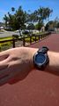
Watch with date
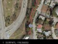
GPS

