Difference between revisions of "2016-06-26 51 0"
imported>Tongs |
imported>Sourcerer m (→Achievements) |
||
| Line 57: | Line 57: | ||
<!-- =============== USEFUL CATEGORIES FOLLOW ================ | <!-- =============== USEFUL CATEGORIES FOLLOW ================ | ||
Delete the next line ONLY if you have chosen the appropriate categories below. If you are unsure, don't worry. People will read your report and help you with the classification. --> | Delete the next line ONLY if you have chosen the appropriate categories below. If you are unsure, don't worry. People will read your report and help you with the classification. --> | ||
| − | |||
<!-- ==REQUEST FOR TWITTER BOT== Please leave either the New report or the Expedition planning category in as long as you work on it. This helps the twitter bot a lot with announcing the right outcome at the right moment. --> | <!-- ==REQUEST FOR TWITTER BOT== Please leave either the New report or the Expedition planning category in as long as you work on it. This helps the twitter bot a lot with announcing the right outcome at the right moment. --> | ||
| Line 70: | Line 69: | ||
[[Category:Expeditions]] | [[Category:Expeditions]] | ||
[[Category:Expeditions with photos]] | [[Category:Expeditions with photos]] | ||
| − | + | [[Category:Coordinates reached]] | |
Revision as of 10:28, 28 June 2016
| Sun 26 Jun 2016 in 51,0: 51.9677691, 0.2178199 geohashing.info google osm bing/os kml crox |
Location
A bean field just over 1km south of Newport (Essex) train station.
Participants
- Tongs/B
- Jeff
Plans
We will take the 12:51 train from Cambridge to arrive Newport at 13:13. We'll walk south to the hashpoint, aiming to arrive about 13:40.
Expedition
This was my first drag-along expedition. Jeff was visiting me for the weekend, and we were thinking of somewhere nice to go for a walk on the Sunday. Walk to Grantchester, or Waterbeach maybe, or, hmm, it looks like there’s possibly a nice walk in Newport. Newport is the site at which the Harcamlow Way crosses itself, so there must be nice walks there. On the map, a narrow slice of woodland separated the railway line from nearby fields, containing the River Cam. Jeff was happy to join in too, though he didn’t really (yet) follow the idea of geohashing. Maybe, I thought, we could walk through a wood, by a river, and pop out in the field near the hashpoint. We only had to walk 1300m from the station. Great. We rushed for the train and started out on the 20 minute ride to that station.
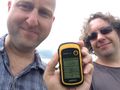
Maybe the first lesson from this expedition is not to make these assumptions. The wood was too dense to walk through, the fields contained tall grass and were not connected to each other, and the Cam was just a stream. After walking through a few hundred metres of long grass, we rejoined the B1383, picked the spiky burrs from the grass out of our legs and socks, and walked directly into the field. It contained densely-sown bean plants, with vehicle tracks to walk along. Retracing our steps a couple of times and exploring the network of tracks, at 14:06, 26 minutes later than planned, we got to within 5 metres of the point. We chose not to go any further to prevent crop damage.
Our reward was promised by a huge sign pointing to the Fleur de Lys, but when we realised it was 1.6km away, we knew time was against us. Jeff needed to get back to Cambridge for a train back home, and we did the sensible thing and headed home. Apart from the local shop, Newport was closed, and a coronation chicken baguette and a couple of Scotch eggs would have to do.
The expedition was considered a success, particularly as this was our first one in the London East graticule. We resolved to leave more time for exploration in the future.
Photos
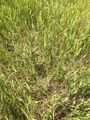
Long grass was to impede us considerably.
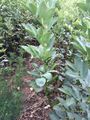
The beans growing in the field containing the hashpoint.

Jeff, doing some genuine geohashing.
Proof that we nearly made it.
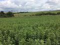
Looking eastwards, the point is somewhere ahead of us.


