Difference between revisions of "2016-06-29 48 9"
From Geohashing
imported>Steingesicht ([live picture]Just more salad.) |
imported>FippeBot m (Location) |
||
| (6 intermediate revisions by 2 users not shown) | |||
| Line 19: | Line 19: | ||
== Location == | == Location == | ||
| + | A field in Filderstadt, between Bernhausen and Bonlanden | ||
<!-- where you've surveyed the hash to be --> | <!-- where you've surveyed the hash to be --> | ||
== Participants == | == Participants == | ||
| + | Steingesicht [[User:Steingesicht|Steingesicht]] ([[User talk:Steingesicht|talk]]) | ||
<!-- who attended: If you link to your wiki user name in this section, your expedition will be picked up by the various statistics generated for geohashing. You may use three tildes ~ as a shortcut to automatically insert the user signature of the account you are editing with. | <!-- who attended: If you link to your wiki user name in this section, your expedition will be picked up by the various statistics generated for geohashing. You may use three tildes ~ as a shortcut to automatically insert the user signature of the account you are editing with. | ||
--> | --> | ||
| Line 30: | Line 32: | ||
== Expedition == | == Expedition == | ||
<!-- how it all turned out. your narrative goes here. --> | <!-- how it all turned out. your narrative goes here. --> | ||
| + | The todays expedition was a success. | ||
| + | The point was on and field with salad. I went there by bike after work. Easy to reach. Sunny weather. | ||
| + | -- [[User:Steingesicht|Steingesicht]] ([[User talk:Steingesicht|talk]]) 23:07, 29 June 2016 (CEST) | ||
| − | |||
| − | |||
| − | |||
== Tracklog == | == Tracklog == | ||
<!-- if your GPS device keeps a log, you may post a link here --> | <!-- if your GPS device keeps a log, you may post a link here --> | ||
| Line 58: | Line 60: | ||
Image:2016-06-29_48_9_steingesicht_1467234692024.jpg|Just more salad. | Image:2016-06-29_48_9_steingesicht_1467234692024.jpg|Just more salad. | ||
| + | |||
| + | Image:2016-06-29_48_9_steingesicht_1467234744084.jpg|View to Bonlanden. | ||
</gallery> | </gallery> | ||
== Achievements == | == Achievements == | ||
{{#vardefine:ribbonwidth|800px}} | {{#vardefine:ribbonwidth|800px}} | ||
| − | |||
| − | |||
| − | |||
| − | |||
| − | |||
| − | |||
| − | |||
| − | |||
| − | |||
| − | |||
| − | |||
| − | |||
| − | |||
| − | |||
| − | |||
[[Category:Expeditions]] | [[Category:Expeditions]] | ||
| − | |||
[[Category:Expeditions with photos]] | [[Category:Expeditions with photos]] | ||
| − | |||
| − | |||
| − | |||
| − | |||
| − | |||
[[Category:Coordinates reached]] | [[Category:Coordinates reached]] | ||
| − | + | {{location|DE|BW|ES}} | |
| − | |||
| − | |||
| − | |||
| − | |||
| − | |||
| − | |||
| − | |||
| − | |||
| − | |||
| − | |||
| − | |||
| − | |||
| − | |||
| − | |||
| − | |||
| − | |||
| − | |||
Latest revision as of 00:53, 16 August 2019
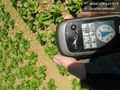
| Wed 29 Jun 2016 in 48,9: 48.6681175, 9.2078103 geohashing.info google osm bing/os kml crox |
Location
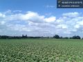
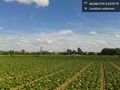
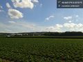
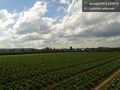
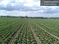
A field in Filderstadt, between Bernhausen and Bonlanden
Participants
Steingesicht Steingesicht (talk)
Plans
Expedition
The todays expedition was a success. The point was on and field with salad. I went there by bike after work. Easy to reach. Sunny weather. -- Steingesicht (talk) 23:07, 29 June 2016 (CEST)
Tracklog
Photos
Hashproof
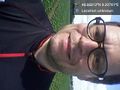
Stupid grin.
North
East
South
West
View to the point
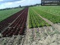
Just more salad.
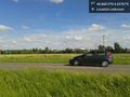
View to Bonlanden.


