Difference between revisions of "2016-07-03 -35 149"
imported>Benjw (re-cat) |
imported>FippeBot m (Location) |
||
| Line 60: | Line 60: | ||
[[Category:Expedition without GPS]] | [[Category:Expedition without GPS]] | ||
[[Category:Coordinates reached]] | [[Category:Coordinates reached]] | ||
| + | {{location|AU|NSW}} | ||
Revision as of 00:55, 16 August 2019
| Sun 3 Jul 2016 in -35,149: -35.1492068, 149.0573026 geohashing.info google osm bing/os kml crox |
Location
In a farm field beside the Wattle Park church, beside the Barton Highway (again west of Hall ACT) near Canberra.
Participants
1PE
Plans
1PE
Go a little out of my way when travelling to another place on the Barton Highway.
Expedition
1PE
I travelled out to the north-west of Canberra and doubled back to park beside the Barton Highway, near an obvious sign to Church Lane that leaves the highway beside the historic Wattle Park Church.
I took pictures with the sign as a marker. (The hash is just over the left end of the sign, near the large tree.)
YES, it has been an exasperating 6 1/2 months since my last successful hash, as nothing has been nearby where I have been.
Tracklog
Photos
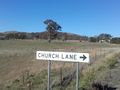
The hash is just over the left end of the sign, near the large tree. That's the church in the right of the picture
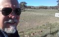
The hash is near my left ear.

