Difference between revisions of "2016-07-06 51 10"
From Geohashing
imported>GeorgDerReisende (new report) |
imported>FippeBot m (Location) |
||
| (One intermediate revision by one other user not shown) | |||
| Line 1: | Line 1: | ||
| + | [[Image:{{{image|2016-07-06 51 10 GeorgDerReisende 7684.jpg}}}|thumb|left]] | ||
| − | |||
| − | |||
| − | |||
| − | |||
| − | |||
| − | |||
| − | |||
| − | |||
| − | |||
{{meetup graticule | {{meetup graticule | ||
| lat=51 | | lat=51 | ||
| Line 19: | Line 11: | ||
== Location == | == Location == | ||
| − | + | ||
| + | The hash lay on a meadow south of Ebergötzen. | ||
== Participants == | == Participants == | ||
| − | + | ||
| − | + | [[User:GeorgDerReisende|GeorgDerReisende]] | |
== Plans == | == Plans == | ||
| − | + | ||
| + | Hitchhiking and walking. Today's expedition was very important, because this day was the 3rd Hashiversary. | ||
== Expedition == | == Expedition == | ||
| − | |||
| − | + | I planned this day a long time beforehand, because it was my 3rd Hashiversary. Then I got a letter for an official appointment. At noon. And I wavered. Could I make an expedition on this day? I could leave the official place at one o'clock. The weather was sunny. And I decided to try this field. I started to hitchhike at 13:35 and arrived at Ebergötzen at 15:30. I walked to the hash and found a meadow, which was just mowed. | |
| − | |||
== Photos == | == Photos == | ||
| − | |||
| − | |||
| − | |||
<gallery perrow="5"> | <gallery perrow="5"> | ||
| + | Image:2016-07-06 51 10 GeorgDerReisende 7707.jpg | butterflies near the hash | ||
| + | Image:2016-07-06 51 10 GeorgDerReisende 7709.jpg | the meadow of hash | ||
| + | Image:2016-07-06 51 10 GeorgDerReisende 7711.jpg | proof | ||
| + | Image:2016-07-06 51 10 GeorgDerReisende 7713.jpg | south | ||
| + | Image:2016-07-06 51 10 GeorgDerReisende 7714.jpg | west | ||
| + | Image:2016-07-06 51 10 GeorgDerReisende 7715.jpg | north | ||
| + | Image:2016-07-06 51 10 GeorgDerReisende 7716.jpg | east | ||
| + | Image:2016-07-06 51 10 GeorgDerReisende 7717.jpg | the geohasher | ||
</gallery> | </gallery> | ||
| Line 45: | Line 42: | ||
<!-- Add any achievement ribbons you earned below, or remove this section --> | <!-- Add any achievement ribbons you earned below, or remove this section --> | ||
| − | + | {{Thumbs Up | latitude = 51 | longitude = 10 | date = 2016-07-06 | name = GeorgDerReisende }} | |
| − | |||
| − | |||
| − | + | {{ Hashiversary | new = 2016-07-06 51 10 | original = 2013-07-06 52 9 | ordinal = 3rd | name = GeorgDerReisende | gender = his }} | |
| − | + | [[Category:Expeditions]] | |
| − | |||
| − | [[Category: | ||
| − | |||
| − | + | [[Category:Expeditions with photos]] | |
| − | |||
| − | |||
| − | |||
| − | |||
| − | |||
| − | |||
| − | |||
| − | |||
| − | |||
[[Category:Coordinates reached]] | [[Category:Coordinates reached]] | ||
| − | + | {{location|DE|NI|GÖ}} | |
| − | |||
| − | |||
| − | |||
| − | |||
| − | |||
| − | |||
| − | |||
| − | |||
| − | |||
| − | |||
| − | |||
| − | |||
| − | |||
| − | |||
| − | |||
| − | |||
| − | |||
Latest revision as of 00:56, 16 August 2019

| Wed 6 Jul 2016 in 51,10: 51.5659015, 10.1038979 geohashing.info google osm bing/os kml crox |
Location
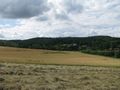
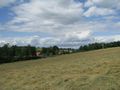
The hash lay on a meadow south of Ebergötzen.
Participants
Plans
Hitchhiking and walking. Today's expedition was very important, because this day was the 3rd Hashiversary.
Expedition
I planned this day a long time beforehand, because it was my 3rd Hashiversary. Then I got a letter for an official appointment. At noon. And I wavered. Could I make an expedition on this day? I could leave the official place at one o'clock. The weather was sunny. And I decided to try this field. I started to hitchhike at 13:35 and arrived at Ebergötzen at 15:30. I walked to the hash and found a meadow, which was just mowed.
Photos
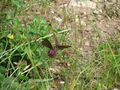
butterflies near the hash
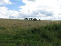
the meadow of hash
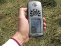
proof
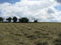
south
west
north

east
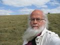
the geohasher


Achievements
GeorgDerReisende earned the Thumbs Up Geohash Achievement
|
GeorgDerReisende earned the 3rd Hashiversary achievement
|