Difference between revisions of "2016-07-08 53 6"
imported>FelixTheCat |
imported>FelixTheCat |
||
| Line 14: | Line 14: | ||
== Expedition == | == Expedition == | ||
| − | I had been planning to visit some interesting places in Friesland province for a while now, so when this hashpoint came up I decided that today would be a good day to head north. I first had a look at the | + | I had been planning to visit some interesting places in Friesland province for a while now, so when this hashpoint came up I decided that today would be a good day to head north. I first had a look at the [https://en.wikipedia.org/wiki/Ir.D.F._Woudagemaal Wouda Pumping Station], which is a large steam-powered installation and World Heritage Site that used to keep Friesland dry. It can still do this, but nowadays it's purely used as backup for other, more powerful pumping stations. Nevertheless, very interesting and worth a visit if you're in the area. |
By the time I left it had started raining, so I decided to postpone the hash and wait for it to clear up, so I visited some museums in Heerenveen and Drachten and had lunch. The weather seemed to be improving in the afternoon, so I headed towards the village of Wijnjewoude and parked my car at the entrance to the forest. The hash wash still about 1 km away, so it was still a bit of a walk, in a forest that was rather soggy in places with all the rain of the past few hours. A sign at the entrace actually explained that this bit of forest is very important for the water supply, since the precipitation that falls here drains into an aquifer that is used for drinking water production. | By the time I left it had started raining, so I decided to postpone the hash and wait for it to clear up, so I visited some museums in Heerenveen and Drachten and had lunch. The weather seemed to be improving in the afternoon, so I headed towards the village of Wijnjewoude and parked my car at the entrance to the forest. The hash wash still about 1 km away, so it was still a bit of a walk, in a forest that was rather soggy in places with all the rain of the past few hours. A sign at the entrace actually explained that this bit of forest is very important for the water supply, since the precipitation that falls here drains into an aquifer that is used for drinking water production. | ||
| − | As I got closer to the hash I had to walk a bit off the footpath and found myself walking along a small drainage ditch that wasn't on my GPS map. After about 175m I discovered that the hash was on the other side of the ditch! It's interesting to know that the national sport of Friesland is something called [[https://en.wikipedia.org/wiki/Fierljeppen | + | As I got closer to the hash I had to walk a bit off the footpath and found myself walking along a small drainage ditch that wasn't on my GPS map. After about 175m I discovered that the hash was on the other side of the ditch! It's interesting to know that the national sport of Friesland is something called [i][https://en.wikipedia.org/wiki/Fierljeppen fierljeppen][/i], which involves jumping over water using a long pole. However, I've never done this myself and didn't have a suitable pole with me either, so I decided to go back and walk around the ditch. I found the spot, took some pictures, tried to avoid the mosquitoes again, and went back. |
| + | |||
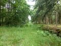
| + | There was also a small pond in the forest (photo 9). Apparently this is left behind by something called a [https://en.wikipedia.org/wiki/Pingo pingo], which sounds like a cute antarctic animal but which is actually a small hill with ice on the inside. These were present here at the end of the Ice Age, and when the climate warmed up they melted and left behind small circular lakes. | ||
| + | |||
| + | Afterwards I went back to my car and on my way to visit the Frisian Museum in Leeuwarden (which was also pretty interesting). | ||
== Photos == | == Photos == | ||
| − | |||
| − | |||
| − | |||
<gallery perrow="5"> | <gallery perrow="5"> | ||
| + | Image:2016-07-08 53 6 FelixTheCat 1.JPG | The entrance to the forest. | ||
| + | Image:2016-07-08 53 6 FelixTheCat 2.JPG | The path, rather muddy in places. | ||
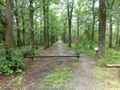
| + | Image:2016-07-08 53 6 FelixTheCat 3.JPG | The hash should be somewhere ahead from here... | ||
| + | Image:2016-07-08 53 6 FelixTheCat 4.JPG | Across this ditch, apparently :-( | ||
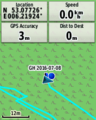
| + | Image:2016-07-08 53 6 FelixTheCat 5.png | Blast! Not [[2016-05-26 52 4|again]]! | ||
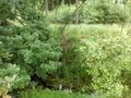
| + | Image:2016-07-08 53 6 FelixTheCat 6.JPG | This is what it looks like on the other side. The grass isn't really greener. | ||
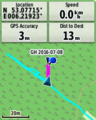
| + | Image:2016-07-08 53 6 FelixTheCat 7.png | Reached it! | ||
| + | Image:2016-07-08 53 6 FelixTheCat 8.JPG | Lloyd happy to have reached the hash. | ||
| + | Image:2016-07-08 53 6 FelixTheCat 9.JPG | The pingo remnant. | ||
| + | Image:2016-07-08 53 6 FelixTheCat 10.JPG | The ground here is seriously soggy. | ||
</gallery> | </gallery> | ||
== Achievements == | == Achievements == | ||
{{#vardefine:ribbonwidth|800px}} | {{#vardefine:ribbonwidth|800px}} | ||
| − | |||
| − | |||
| − | |||
| − | |||
| − | |||
| − | |||
| − | |||
| − | |||
| − | |||
| − | |||
| − | |||
| − | |||
| − | |||
| − | |||
| − | |||
| − | |||
[[Category:Expeditions]] | [[Category:Expeditions]] | ||
| − | |||
[[Category:Expeditions with photos]] | [[Category:Expeditions with photos]] | ||
| − | |||
| − | |||
| − | |||
| − | |||
| − | |||
[[Category:Coordinates reached]] | [[Category:Coordinates reached]] | ||
| − | |||
| − | |||
| − | |||
| − | |||
| − | |||
| − | |||
| − | |||
| − | |||
| − | |||
| − | |||
| − | |||
| − | |||
| − | |||
| − | |||
| − | |||
| − | |||
| − | |||
| − | |||
Revision as of 20:46, 8 July 2016
| Fri 8 Jul 2016 in 53,6: 53.0772587, 6.2192315 geohashing.info google osm bing/os kml crox |
Location
In a forest in Wijnjewoude, Friesland.
Participants
Expedition
I had been planning to visit some interesting places in Friesland province for a while now, so when this hashpoint came up I decided that today would be a good day to head north. I first had a look at the Wouda Pumping Station, which is a large steam-powered installation and World Heritage Site that used to keep Friesland dry. It can still do this, but nowadays it's purely used as backup for other, more powerful pumping stations. Nevertheless, very interesting and worth a visit if you're in the area.
By the time I left it had started raining, so I decided to postpone the hash and wait for it to clear up, so I visited some museums in Heerenveen and Drachten and had lunch. The weather seemed to be improving in the afternoon, so I headed towards the village of Wijnjewoude and parked my car at the entrance to the forest. The hash wash still about 1 km away, so it was still a bit of a walk, in a forest that was rather soggy in places with all the rain of the past few hours. A sign at the entrace actually explained that this bit of forest is very important for the water supply, since the precipitation that falls here drains into an aquifer that is used for drinking water production.
As I got closer to the hash I had to walk a bit off the footpath and found myself walking along a small drainage ditch that wasn't on my GPS map. After about 175m I discovered that the hash was on the other side of the ditch! It's interesting to know that the national sport of Friesland is something called [i]fierljeppen[/i], which involves jumping over water using a long pole. However, I've never done this myself and didn't have a suitable pole with me either, so I decided to go back and walk around the ditch. I found the spot, took some pictures, tried to avoid the mosquitoes again, and went back.
There was also a small pond in the forest (photo 9). Apparently this is left behind by something called a pingo, which sounds like a cute antarctic animal but which is actually a small hill with ice on the inside. These were present here at the end of the Ice Age, and when the climate warmed up they melted and left behind small circular lakes.
Afterwards I went back to my car and on my way to visit the Frisian Museum in Leeuwarden (which was also pretty interesting).
Photos
The entrance to the forest.
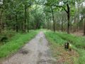
The path, rather muddy in places.
The hash should be somewhere ahead from here...
Across this ditch, apparently :-(
Blast! Not again!
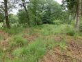
This is what it looks like on the other side. The grass isn't really greener.
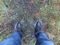
Reached it!
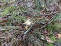
Lloyd happy to have reached the hash.
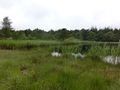
The pingo remnant.
The ground here is seriously soggy.


