Difference between revisions of "2016-07-13 41 2"
From Geohashing
imported>Tads m |
imported>FippeBot m (Location) |
||
| (One intermediate revision by one other user not shown) | |||
| Line 27: | Line 27: | ||
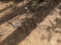
Image:tads_2016-07-13_41_2_proof.png | GPS proof | Image:tads_2016-07-13_41_2_proof.png | GPS proof | ||
Image:tads_2016-07-13_41_2_panorama.jpg | panorama view from the park down on Barcelona | Image:tads_2016-07-13_41_2_panorama.jpg | panorama view from the park down on Barcelona | ||
| + | </gallery> | ||
more to come | more to come | ||
| − | |||
| − | |||
== Achievements == | == Achievements == | ||
{{#vardefine:ribbonwidth|800px}} | {{#vardefine:ribbonwidth|800px}} | ||
| − | |||
| − | |||
| − | |||
| − | |||
| − | |||
[[Category:Expeditions]] | [[Category:Expeditions]] | ||
[[Category:Expeditions with photos]] | [[Category:Expeditions with photos]] | ||
[[Category:Coordinates reached]] | [[Category:Coordinates reached]] | ||
| + | {{location|ES|CT|B}} | ||
Latest revision as of 01:00, 16 August 2019
| Wed 13 Jul 2016 in 41,2: 41.3992122, 2.1119300 geohashing.info google osm bing/os kml crox |
Location
Parc de l'Oreneta in Barcelona
Participants
Plans
Visit the park and find the hashpoint on my way back from work to the hotel.
Expedition
ToDo
Photos
XKCD mark
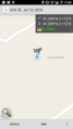
GPS proof
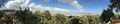
panorama view from the park down on Barcelona


more to come