Difference between revisions of "2016-07-21 43 -78"
imported>Pedalpusher (New report) |
imported>FippeBot m (Location) |
||
| (3 intermediate revisions by one other user not shown) | |||
| Line 7: | Line 7: | ||
*[[User:Pedalpusher|Pedalpusher]] | *[[User:Pedalpusher|Pedalpusher]] | ||
| − | == Expedition == | + | == Plans == |
| + | Had some vendors for work coming into town so I went into the office. Didn't know the coordinates yet so I figured I'd check on my phone at the proper time. | ||
| + | |||
| + | They were decent for the Buffalo graticule in Allegany State Park but I checked the Lockport hash just in case. It appeared reachable as I could park all the way in the back of the cemetery. I would just have to hope the woods there weren't posted. I was also thinking if I could get out of work a bit early, I could hit this hash on the way home and then take the dogs to Allegany for a Double Hash. | ||
| + | |||
| + | == Expedition == | ||
| + | Getting out of work, I checked my phone for directions to the hash. They seemed simple enough, but I still missed a connecting road after going over Tonawanda Creek. Getting back on track, it was simple enough to find the cemetery and I picked the correct roads to get to the very back. I found dirt mounds and the woods where the hash would be and parked the car. Now, normally, I would be using my GPS and I could have sworn I put it in the car, but I couldn't find it when I reached under the driver's seat. Undeterred, I turned on the Mobile Data on my phone and used the Geohashing app for the first time to find the hash. | ||
| + | |||
| + | It worked really well as I climbed over the dirt mounds and into the woods. I found I was walking through what would normally be a swamp, but with the drought we are in, was just about all dried up. This would have been quite messy and maybe impossible otherwise. I was able to successfully get to the hash and get my proof before heading home to take the dogs out. | ||
| + | |||
| + | Unfortunately, I got stuck in rush-hour traffic on the way home and it would have been too late to drive to Allegany for a second hash without running out of daylight. I took the dogs to a local park instead where they enjoyed themselves, nonetheless. | ||
== Photos == | == Photos == | ||
<gallery perrow="5"> | <gallery perrow="5"> | ||
| − | Image: | + | Image: 2016-07-21 parked.jpg | The mounds of dirt that I'm about to walk over. |
| − | Image: | + | Image: 2016-07-21 walking.jpg| Walking through the woods. It's hard to tell from the picture that this is normally pretty swampy. |
| − | Image: | + | Image: 2016-07-21 hashView.jpg | Very Close! The hash is on the other side of the path in the trees. |
| − | Image: | + | Image: 2016-07-21 screenShot.png | Made it. |
| − | Image: | + | Image: 2016-07-21 stupidGrin.jpg | Almost a Formal Geohash, but since we don't deal directly with customers, it's business casual at work. |
| − | |||
| − | |||
| − | |||
</gallery> | </gallery> | ||
| Line 28: | Line 35: | ||
}} | }} | ||
| − | |||
[[Category:Expeditions]] | [[Category:Expeditions]] | ||
[[Category:Coordinates reached]] | [[Category:Coordinates reached]] | ||
| − | + | [[Category:Expeditions with photos]] | |
| + | {{location|US|NY|NI}} | ||
Latest revision as of 01:03, 16 August 2019
| Thu 21 Jul 2016 in 43,-78: 43.0668948, -78.8118499 geohashing.info google osm bing/os kml crox |
Location
In the woods by Acadia Park Cemetery
Participants
Plans
Had some vendors for work coming into town so I went into the office. Didn't know the coordinates yet so I figured I'd check on my phone at the proper time.
They were decent for the Buffalo graticule in Allegany State Park but I checked the Lockport hash just in case. It appeared reachable as I could park all the way in the back of the cemetery. I would just have to hope the woods there weren't posted. I was also thinking if I could get out of work a bit early, I could hit this hash on the way home and then take the dogs to Allegany for a Double Hash.
Expedition
Getting out of work, I checked my phone for directions to the hash. They seemed simple enough, but I still missed a connecting road after going over Tonawanda Creek. Getting back on track, it was simple enough to find the cemetery and I picked the correct roads to get to the very back. I found dirt mounds and the woods where the hash would be and parked the car. Now, normally, I would be using my GPS and I could have sworn I put it in the car, but I couldn't find it when I reached under the driver's seat. Undeterred, I turned on the Mobile Data on my phone and used the Geohashing app for the first time to find the hash.
It worked really well as I climbed over the dirt mounds and into the woods. I found I was walking through what would normally be a swamp, but with the drought we are in, was just about all dried up. This would have been quite messy and maybe impossible otherwise. I was able to successfully get to the hash and get my proof before heading home to take the dogs out.
Unfortunately, I got stuck in rush-hour traffic on the way home and it would have been too late to drive to Allegany for a second hash without running out of daylight. I took the dogs to a local park instead where they enjoyed themselves, nonetheless.
Photos
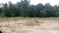
The mounds of dirt that I'm about to walk over.
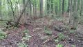
Walking through the woods. It's hard to tell from the picture that this is normally pretty swampy.
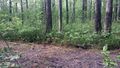
Very Close! The hash is on the other side of the path in the trees.
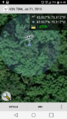
Made it.

Almost a Formal Geohash, but since we don't deal directly with customers, it's business casual at work.


Ribbons
This user earned the Land geohash achievement
|