Difference between revisions of "2016-07-24 51 9"
From Geohashing
imported>GeorgDerReisende (new report) |
imported>GeorgDerReisende (expedition report for Zierenberg) |
||
| Line 1: | Line 1: | ||
| − | |||
| − | |||
| − | |||
| − | |||
| − | |||
| − | |||
| − | |||
| − | |||
| − | |||
| − | |||
{{meetup graticule | {{meetup graticule | ||
| lat=51 | | lat=51 | ||
| Line 19: | Line 9: | ||
== Location == | == Location == | ||
| − | + | ||
| + | The hash lay on a field southeast of Zierenberg. | ||
== Participants == | == Participants == | ||
| − | + | ||
| − | + | [[User:GeorgDerReisende|GeorgDerReisende]] | |
== Plans == | == Plans == | ||
| − | + | ||
| + | Hitchhiking to Zierenberg and walking to the hash. | ||
== Expedition == | == Expedition == | ||
| − | |||
| − | + | It happened as planned. I hitchhiked to Zierenberg and went to the hash. The field was not harvested. Some parts of the field looked like trampled down in lines, not like by storms and not like by corn circles. But I decided not to walk onto the field. | |
| − | |||
== Photos == | == Photos == | ||
| Line 39: | Line 29: | ||
--> | --> | ||
<gallery perrow="5"> | <gallery perrow="5"> | ||
| + | Image:2016-07-24 51 9 GeorgDerReisende 9266.jpg | the site of the hash | ||
| + | Image:2016-07-24 51 9 GeorgDerReisende 9267.jpg | trampled down field | ||
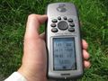
| + | Image:2016-07-24 51 9 GeorgDerReisende 9268.jpg | 46 meters to hash | ||
| + | Image:2016-07-24 51 9 GeorgDerReisende 9270.jpg | 46 meters too far | ||
| + | Image:2016-07-24 51 9 GeorgDerReisende 9272.jpg | looking north | ||
| + | Image:2016-07-24 51 9 GeorgDerReisende 9273.jpg | looking east | ||
| + | Image:2016-07-24 51 9 GeorgDerReisende 9274.jpg | looking south | ||
| + | Image:2016-07-24 51 9 GeorgDerReisende 9275.jpg | looking to Zierenberg | ||
</gallery> | </gallery> | ||
| − | + | [[Category:Expeditions]] | |
| − | |||
| − | |||
| − | |||
| − | |||
| − | |||
| − | |||
| − | |||
| − | |||
| − | |||
| − | |||
| − | |||
| − | |||
| − | |||
| − | |||
| − | |||
| − | |||
| − | |||
| − | |||
[[Category:Expeditions with photos]] | [[Category:Expeditions with photos]] | ||
| − | |||
| − | |||
| − | |||
| − | |||
| − | |||
| − | |||
| + | [[Category:Coordinates not reached]] | ||
| − | |||
| − | |||
| − | |||
| − | |||
[[Category:Not reached - Mother Nature]] | [[Category:Not reached - Mother Nature]] | ||
| − | |||
| − | |||
| − | |||
| − | |||
| − | |||
| − | |||
| − | |||
| − | |||
| − | |||
| − | |||
| − | |||
Revision as of 21:04, 9 August 2016
| Sun 24 Jul 2016 in 51,9: 51.3583490, 9.3215809 geohashing.info google osm bing/os kml crox |
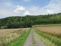
Location
The hash lay on a field southeast of Zierenberg.
Participants
Plans
Hitchhiking to Zierenberg and walking to the hash.
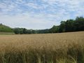
Expedition
It happened as planned. I hitchhiked to Zierenberg and went to the hash. The field was not harvested. Some parts of the field looked like trampled down in lines, not like by storms and not like by corn circles. But I decided not to walk onto the field.
Photos
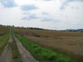
the site of the hash
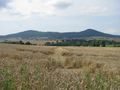
trampled down field
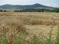
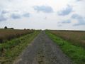
46 meters to hash
46 meters too far
looking north
looking east
looking south
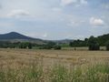
looking to Zierenberg


