Difference between revisions of "2016-08-03 52 1"
From Geohashing
imported>Sourcerer m (→Achievements) |
imported>Sourcerer m (Uploading from home.) |
||
| Line 24: | Line 24: | ||
== Photos == | == Photos == | ||
<gallery caption="Photo Gallery" widths="200px" heights="200px" perrow="3"> | <gallery caption="Photo Gallery" widths="200px" heights="200px" perrow="3"> | ||
| + | |||
| + | Image:2016-08-03_52_1_Sourcerer_1470179038923.jpg | Uploading from home. | ||
</gallery> | </gallery> | ||
Revision as of 23:55, 2 August 2016
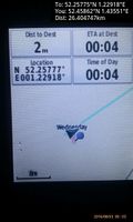
| Wed 3 Aug 2016 in Norwich, UK: 52.2577483, 1.2291789 geohashing.info google osm bing/os kml crox |
Location
A field north of Monk Soham Green, Suffolk, UK.
Participants
Plans
Two of two spanning midnight - 2016-08-02 52 1 - 2016-08-03 52 1 - ETA 00:00.
Expedition
Photos
- Photo Gallery
Uploading from home.

Achievements
Sourcerer earned the Midnight Geohash achievement
|
Sourcerer earned the OpenStreetMap achievement
|
Expeditions and Plans
| 2016-08-03 | ||
|---|---|---|
| Big Rapids, Michigan | Mcbaneg, Katja, Rebekah | Saul Lake Bog Nature Preserve, Rockford, MI |
| Norwich, United Kingdom | Sourcerer | A field north of Monk Soham Green, Suffolk, UK. |
Sourcerer's Expedition Links
2016-08-02 52 1 - 2016-08-03 52 1 - 2016-08-04 52 1 - KML file download of Sourcerer's expeditions for use with Google Earth.