Difference between revisions of "2016-08-04 51 9"
From Geohashing
imported>GeorgDerReisende (new report) |
imported>GeorgDerReisende (expedition report for Kassel-Rothenditmold) |
||
| Line 1: | Line 1: | ||
| − | |||
| − | |||
| − | |||
| − | |||
| − | |||
| − | |||
| − | |||
| − | |||
| − | |||
| − | |||
{{meetup graticule | {{meetup graticule | ||
| lat=51 | | lat=51 | ||
| Line 19: | Line 9: | ||
== Location == | == Location == | ||
| − | + | ||
| + | The hash lay on the back side of a building in Kassel-Rothenditmold. | ||
== Participants == | == Participants == | ||
| − | + | ||
| − | + | [[User:GeorgDerReisende|GeorgDerReisende]] | |
== Plans == | == Plans == | ||
| − | + | ||
| + | Taking the bus and a little walk. | ||
== Expedition == | == Expedition == | ||
| − | |||
| − | + | I started in the late afternoon to get a time, when no other people were around there. I found the hash easy on the back side of the building. | |
| − | |||
== Photos == | == Photos == | ||
| − | |||
| − | |||
| − | |||
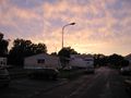
<gallery perrow="5"> | <gallery perrow="5"> | ||
| + | Image:2016-08-04 51 9 GeorgDerReisende 0531.jpg | the building, where the hash was behind | ||
| + | Image:2016-08-04 51 9 GeorgDerReisende 0533.jpg | the backyard | ||
| + | Image:2016-08-04 51 9 GeorgDerReisende 0535.jpg | the backyard with the hash | ||
| + | Image:2016-08-04 51 9 GeorgDerReisende 0537.jpg | proof | ||
| + | Image:2016-08-04 51 9 GeorgDerReisende 0539.jpg | the north | ||
| + | Image:2016-08-04 51 9 GeorgDerReisende 0540.jpg | the east | ||
| + | Image:2016-08-04 51 9 GeorgDerReisende 0541.jpg | the south | ||
| + | Image:2016-08-04 51 9 GeorgDerReisende 0542.jpg | the west | ||
| + | Image:2016-08-04 51 9 GeorgDerReisende 0546.jpg | the Angersbachstraße to the east | ||
| + | Image:2016-08-04 51 9 GeorgDerReisende 0552.jpg | the Angersbachstraße to the west | ||
</gallery> | </gallery> | ||
| Line 45: | Line 42: | ||
<!-- Add any achievement ribbons you earned below, or remove this section --> | <!-- Add any achievement ribbons you earned below, or remove this section --> | ||
| − | + | {{land geohash | latitude = 51 | longitude = 9 | date = 2016-08-04 | name = GeorgDerReisende }} | |
| − | |||
| − | |||
| − | + | [[Category:Expeditions]] | |
| − | + | [[Category:Expeditions with photos]] | |
| − | |||
| − | |||
| − | |||
| − | |||
| − | |||
| − | |||
| − | |||
| − | |||
| − | |||
| − | |||
| − | |||
| − | |||
| − | |||
| − | |||
[[Category:Coordinates reached]] | [[Category:Coordinates reached]] | ||
| − | |||
| − | |||
| − | |||
| − | |||
| − | |||
| − | |||
| − | |||
| − | |||
| − | |||
| − | |||
| − | |||
| − | |||
| − | |||
| − | |||
| − | |||
| − | |||
| − | |||
| − | |||
Revision as of 22:19, 21 August 2016
| Thu 4 Aug 2016 in 51,9: 51.3230370, 9.4682522 geohashing.info google osm bing/os kml crox |
Location
The hash lay on the back side of a building in Kassel-Rothenditmold.
Participants
Plans
Taking the bus and a little walk.
Expedition
I started in the late afternoon to get a time, when no other people were around there. I found the hash easy on the back side of the building.
Photos
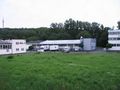
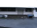
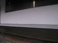
the building, where the hash was behind
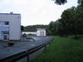
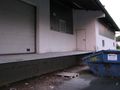
the backyard
the backyard with the hash
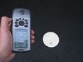
proof
the north
the east
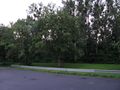
the south
the west
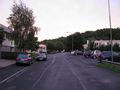
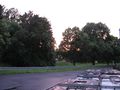
the Angersbachstraße to the east
the Angersbachstraße to the west


Achievements
GeorgDerReisende earned the Land geohash achievement
|