Difference between revisions of "2016-08-05 49 8"
imported>DODO (→Location) |
imported>FippeBot m (Location) |
||
| (5 intermediate revisions by one other user not shown) | |||
| Line 25: | Line 25: | ||
<!-- who attended: If you link to your wiki user name in this section, your expedition will be picked up by the various statistics generated for geohashing. You may use three tildes ~ as a shortcut to automatically insert the user signature of the account you are editing with. | <!-- who attended: If you link to your wiki user name in this section, your expedition will be picked up by the various statistics generated for geohashing. You may use three tildes ~ as a shortcut to automatically insert the user signature of the account you are editing with. | ||
--> | --> | ||
| + | [[User:DODO|DODO]] | ||
== Plans == | == Plans == | ||
| Line 31: | Line 32: | ||
== Expedition == | == Expedition == | ||
<!-- how it all turned out. your narrative goes here. --> | <!-- how it all turned out. your narrative goes here. --> | ||
| + | Had a day of (but I still had a lot of work). But the hash was so close to my home, that I just had to go. | ||
| + | Started on my bike at home around 12 o'clock. Had a short visit at the market to buy some bread, eggs and vegetables. Than I continued my way to Schifferstadt crossed the railroad at the station Schifferstadt Süd and soon reached the motorway. I crossed it on a bridge and soon came close to my aim. Locked the bike and walked some 50 meters, than I had to go into the forest. It tried to protect the hash with dense blackberry copse but there was a passthrough that I could use to enter the forest. Some more steps and I had reached the circle of uncertainty. I took some pictures, and left a mark. During that the gps signal has moved 20 m further and so I wasn't sure if this was exactly the right point. So I tried dancing again and got a zero 20 m further. So if any ninja found finds a mark 20 m of the hash, be assured I've visited the right point also. | ||
| + | |||
| + | When I looked on the map for the way back I got a wild idea. I still could finish a tron (or at least my bike can, but hash dancing doesn't count for iron-trials, does it). What should I tell. It worked, and 80 minutes after I started I reached home again. | ||
== Tracklog == | == Tracklog == | ||
<!-- if your GPS device keeps a log, you may post a link here --> | <!-- if your GPS device keeps a log, you may post a link here --> | ||
| + | [https://www.komoot.de/tour/11077605 22 KM by bike] | ||
== Photos == | == Photos == | ||
| Line 40: | Line 46: | ||
--> | --> | ||
<gallery perrow="5"> | <gallery perrow="5"> | ||
| + | Image:2016-08-05_49_8-1.jpg|my bike, proof of transport | ||
| + | Image:2016-08-05_49_8-2.jpg|blackberries | ||
| + | Image:2016-08-05_49_8-3.jpg|view to the east | ||
| + | Image:2016-08-05_49_8-4.jpg|and the north | ||
| + | Image:2016-08-05_49_8-5.jpg|mark | ||
| + | Image:2016-08-05_49_8-6.jpg|hasher | ||
| + | Image:2016-08-05_49_8-7.png|first proof | ||
| + | Image:2016-08-05_49_8-8.png|second proof. There are 20 m difference between these two | ||
</gallery> | </gallery> | ||
| Line 46: | Line 60: | ||
<!-- Add any achievement ribbons you earned below, or remove this section --> | <!-- Add any achievement ribbons you earned below, or remove this section --> | ||
| − | + | {{land geohash | |
| − | + | | latitude = 49 | |
| − | + | | longitude = 8 | |
| − | + | | date = 2016-08-05 | |
| − | + | | name = DODO | |
| + | }} | ||
| − | + | {{Template:Tron | |
| − | + | | latitude = 49 | |
| − | + | | longitude = 8 | |
| − | + | | date = 2016-08-05 | |
| + | | name = DODO | ||
| + | | possessive = his | ||
| + | }} | ||
| − | + | {{bicycle geohash | |
| + | | latitude = 49 | ||
| + | | longitude = 8 | ||
| + | | date = 2016-08-05 | ||
| + | | name = DODO | ||
| + | | distance = 22 KM | ||
| + | }} | ||
| − | |||
[[Category:Expeditions]] | [[Category:Expeditions]] | ||
| − | |||
| − | |||
| − | |||
| − | |||
| − | |||
| − | |||
| − | |||
[[Category:Coordinates reached]] | [[Category:Coordinates reached]] | ||
| − | + | {{location|DE|RP|RP}} | |
| − | |||
| − | |||
| − | |||
| − | |||
| − | |||
| − | |||
| − | |||
| − | |||
| − | |||
| − | |||
| − | |||
| − | |||
| − | |||
| − | |||
| − | |||
| − | |||
| − | |||
Latest revision as of 01:10, 16 August 2019
| Fri 5 Aug 2016 in 49,8: 49.3611951, 8.3567240 geohashing.info google osm bing/os kml crox |
Location
In the forest near Schifferstadt.
Participants
Plans
Expedition
Had a day of (but I still had a lot of work). But the hash was so close to my home, that I just had to go. Started on my bike at home around 12 o'clock. Had a short visit at the market to buy some bread, eggs and vegetables. Than I continued my way to Schifferstadt crossed the railroad at the station Schifferstadt Süd and soon reached the motorway. I crossed it on a bridge and soon came close to my aim. Locked the bike and walked some 50 meters, than I had to go into the forest. It tried to protect the hash with dense blackberry copse but there was a passthrough that I could use to enter the forest. Some more steps and I had reached the circle of uncertainty. I took some pictures, and left a mark. During that the gps signal has moved 20 m further and so I wasn't sure if this was exactly the right point. So I tried dancing again and got a zero 20 m further. So if any ninja found finds a mark 20 m of the hash, be assured I've visited the right point also.
When I looked on the map for the way back I got a wild idea. I still could finish a tron (or at least my bike can, but hash dancing doesn't count for iron-trials, does it). What should I tell. It worked, and 80 minutes after I started I reached home again.
Tracklog
Photos

my bike, proof of transport

blackberries
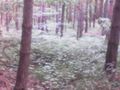
view to the east
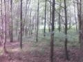
and the north

mark

hasher

first proof
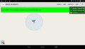
second proof. There are 20 m difference between these two


Achievements
DODO earned the Land geohash achievement
|
DODO earned the Tron achievement
|
DODO earned the Bicycle geohash achievement
|