Difference between revisions of "2016-08-13 59 18"
imported>Belteshassar (Add Belteshassar's expedition) |
imported>FippeBot m (Location) |
||
| (3 intermediate revisions by 2 users not shown) | |||
| Line 27: | Line 27: | ||
== Expedition == | == Expedition == | ||
| + | === Belteshassar === | ||
| + | I left home in Kungsholmen around 11 am and decided to walk in order to hatch some eggs in Pokémon Go. I followed the water until past City Hall and the Government HQ and turned left onto Regeringsgatan. | ||
| + | |||
| + | When I reached the crossing with Kungsgatan, I realised that Regeringsgatan is much higher. I then had to walk around the block. | ||
| + | |||
=== Per S === | === Per S === | ||
I decided to take the bike and earn the bicycle geohash achievement. The hash was only about 5 km (3 miles) from home and the ride took about 20 minutes in nice, sunny weather. I arrived on time and hung around about 20 minutes, trying to get a decent GPS fix and taking a few pictures. | I decided to take the bike and earn the bicycle geohash achievement. The hash was only about 5 km (3 miles) from home and the ride took about 20 minutes in nice, sunny weather. I arrived on time and hung around about 20 minutes, trying to get a decent GPS fix and taking a few pictures. | ||
It was a bit hard to get a good GPS fix, as [[User:Belteshassar|Belteshassar]] mentions below, but I think I found the hashpoint. | It was a bit hard to get a good GPS fix, as [[User:Belteshassar|Belteshassar]] mentions below, but I think I found the hashpoint. | ||
| − | |||
| − | |||
| − | |||
| − | |||
| − | |||
== Photos == | == Photos == | ||
| Line 52: | Line 52: | ||
== Achievements == | == Achievements == | ||
| + | {{Walk geohash | ||
| + | | latitude = 59 | ||
| + | | longitude = 18 | ||
| + | | date = 2016-08-13 | ||
| + | | name = [[User:Belteshassar|Belteshassar]] | ||
| + | }} | ||
| + | |||
{{bicycle geohash | {{bicycle geohash | ||
| latitude = 59 | | latitude = 59 | ||
| Line 65: | Line 72: | ||
[[Category:Expeditions with photos]] | [[Category:Expeditions with photos]] | ||
[[Category:Coordinates reached]] | [[Category:Coordinates reached]] | ||
| + | {{location|SE|AB}} | ||
Latest revision as of 01:13, 16 August 2019

|
| ||||||
Location
On the sidewalk near Kungsgatan 15 in central Stockholm.
Participants
Plans
Per S
To be there at 4:00 PM, the official Saturday meetup time.
Expedition
Belteshassar
I left home in Kungsholmen around 11 am and decided to walk in order to hatch some eggs in Pokémon Go. I followed the water until past City Hall and the Government HQ and turned left onto Regeringsgatan.
When I reached the crossing with Kungsgatan, I realised that Regeringsgatan is much higher. I then had to walk around the block.
Per S
I decided to take the bike and earn the bicycle geohash achievement. The hash was only about 5 km (3 miles) from home and the ride took about 20 minutes in nice, sunny weather. I arrived on time and hung around about 20 minutes, trying to get a decent GPS fix and taking a few pictures.
It was a bit hard to get a good GPS fix, as Belteshassar mentions below, but I think I found the hashpoint.
Photos
Belteshassar
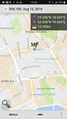
GPS gets lost in urban environment, but I think this is the spot. No good Pokémon nearby unfortunately. @59.3362,18.0691

Per S
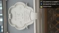
Today's Citation
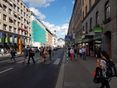
Kungsgatan
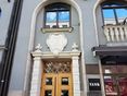
The Hashpoint
Coordinates Reached

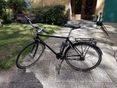
The Geohasher


Achievements
Belteshassar earned the Walk geohash Achievement
|
Per S earned the Bicycle geohash achievement
|