Difference between revisions of "2016-08-16 -15 135"
imported>Felix Dance (added photos) |
m (per Renaming Proposal) |
||
| (8 intermediate revisions by 4 users not shown) | |||
| Line 16: | Line 16: | ||
== Expedition == | == Expedition == | ||
| − | I'm still on my Darwin to Cairns cycle tour mentioned in my previous geohash along the way ([[2016-08-06 -13 131]]), and, just starting along the notorious Savannah Way I happened to get my first bit of reception in several days at the Tomato Island camping ground. Obviously I checked the geohashes because why not although pfft way out here what's the point and WOAH! An achievable one only 860m off the road... 200m from my planned campsite! What are the odds!? (75 thousand to one). | + | I'm still on my Darwin to Cairns cycle tour mentioned in my previous geohash along the way ([[2016-08-06 -13 131]]), and, just starting along the notorious Savannah Way, I happened to get my first bit of reception in several days at the Tomato Island camping ground. Obviously, I checked the geohashes because why not although pfft way out here in the bush what's the point and WOAH! An achievable one only 860m off the road... 200m from my planned campsite! What are the odds!? (75 thousand to one). |
| − | So off I went, 80 kms of rough, unsealed, sandy, corrugated awfulness... of | + | So off I went, 80 kms of rough, unsealed, sandy, corrugated awfulness... of awesomenes! Although I'd planned to do the 80 kms anyway, knowing that I just HAD to do it made it that much worse. |
| − | Late in the afternoon, as the sun was nearing its final resting place on the horizon (I hear folks say this is not the case), I was there. Towns River crossed the road at a | + | Late in the afternoon, as the sun was nearing its final resting place on the horizon (I hear folks say this is not the case), I was there. Towns River crossed the road at a ford, and angry signs warned of the croc danger. Heedful of these, I rode off into the bush, dropped the bike and proceeded on foot along the left bank of the river. A few obvious claw marks from recent croc emergences helpfully marked the way. |
| − | After about half an hour of bush scrambling, picking off broken twigs and bright yellow spiders, | + | After about half an hour of bush scrambling, picking off broken twigs and bright yellow spiders, I emerged into a big clearing, a dried up billabong. Here lay the hash. I took photos and returned, far more smugly than I really deserved to be. I told myself stories of my exploits that night around my campfire just opposite the river from the hash. |
== Photos == | == Photos == | ||
| Line 29: | Line 29: | ||
--> | --> | ||
<gallery perrow="5"> | <gallery perrow="5"> | ||
| + | Image:20160816163252 Scratch.JPG|Recent croc scratch near the hash | ||
Image:20160816165528 River.jpg|Towns River, 100m from the hash | Image:20160816165528 River.jpg|Towns River, 100m from the hash | ||
| Line 35: | Line 36: | ||
Image:20160816164704 GPS.png|Got to within 60cm! | Image:20160816164704 GPS.png|Got to within 60cm! | ||
| + | |||
| + | Image:20160816164959 Sun.JPG|Dried up billabong at the hash | ||
</gallery> | </gallery> | ||
| Line 40: | Line 43: | ||
{{#vardefine:ribbonwidth|800px}} | {{#vardefine:ribbonwidth|800px}} | ||
<!-- Add any achievement ribbons you earned below, or remove this section --> | <!-- Add any achievement ribbons you earned below, or remove this section --> | ||
| − | |||
| − | |||
| − | |||
| − | |||
| − | |||
| − | |||
| − | |||
| − | |||
| − | |||
| − | |||
| − | |||
| − | |||
| − | |||
| − | |||
| − | |||
| − | |||
| − | |||
| − | |||
| − | |||
| − | |||
| − | |||
| − | |||
| − | |||
| − | |||
| − | |||
| − | |||
| − | |||
| − | |||
| − | |||
| − | |||
| − | |||
| − | |||
| − | |||
| − | |||
{{bicycle geohash | {{bicycle geohash | ||
| Line 85: | Line 54: | ||
| image = | | image = | ||
}} | }} | ||
| + | |||
| + | {{Graticule unlocked | ||
| + | |||
| + | | latitude = -15 | ||
| + | | longitude = 135 | ||
| + | | date = 2016-08-16 | ||
| + | | name = [[User:Felix Dance|Felix Dance]] | ||
| + | | image = 20160816164734 Felix.jpg | ||
| + | }} | ||
| + | |||
| + | [[Category:Expeditions]] | ||
| + | [[Category:Expeditions with photos]] | ||
| + | [[Category:Coordinates reached]] | ||
| + | {{location|AU|NT|RG}} | ||
Latest revision as of 04:59, 20 March 2024
| Tue 16 Aug 2016 in -15,135: -15.0373424, 135.2151241 geohashing.info google osm bing/os kml crox |
Location
In the bush next to Towns River, opposite the camping ground on the Savannah Way.
Participants
Expedition
I'm still on my Darwin to Cairns cycle tour mentioned in my previous geohash along the way (2016-08-06 -13 131), and, just starting along the notorious Savannah Way, I happened to get my first bit of reception in several days at the Tomato Island camping ground. Obviously, I checked the geohashes because why not although pfft way out here in the bush what's the point and WOAH! An achievable one only 860m off the road... 200m from my planned campsite! What are the odds!? (75 thousand to one).
So off I went, 80 kms of rough, unsealed, sandy, corrugated awfulness... of awesomenes! Although I'd planned to do the 80 kms anyway, knowing that I just HAD to do it made it that much worse.
Late in the afternoon, as the sun was nearing its final resting place on the horizon (I hear folks say this is not the case), I was there. Towns River crossed the road at a ford, and angry signs warned of the croc danger. Heedful of these, I rode off into the bush, dropped the bike and proceeded on foot along the left bank of the river. A few obvious claw marks from recent croc emergences helpfully marked the way.
After about half an hour of bush scrambling, picking off broken twigs and bright yellow spiders, I emerged into a big clearing, a dried up billabong. Here lay the hash. I took photos and returned, far more smugly than I really deserved to be. I told myself stories of my exploits that night around my campfire just opposite the river from the hash.
Photos
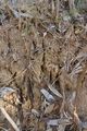
Recent croc scratch near the hash
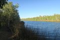
Towns River, 100m from the hash
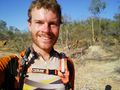
Me at the hash
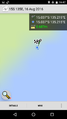
Got to within 60cm!
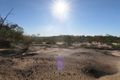
Dried up billabong at the hash


Achievements
Felix Dance (talk) earned the Bicycle geohash achievement
|
Felix Dance earned the Graticule Unlocked Achievement
|