Difference between revisions of "2016-08-20 48 16"
imported>Micsnare (→Tracklog) |
imported>FippeBot m (Location) |
||
| (5 intermediate revisions by 2 users not shown) | |||
| Line 36: | Line 36: | ||
*Yay, it was possible!! -- [[User:Micsnare|Micsnare]] ([[User talk:Micsnare|talk]]) [http://www.openstreetmap.org/?lat=48.20139330&lon=16.29707070&zoom=16&layers=B000FTF @48.2014,16.2971] 17:29, 20 August 2016 (GMT+02:00) | *Yay, it was possible!! -- [[User:Micsnare|Micsnare]] ([[User talk:Micsnare|talk]]) [http://www.openstreetmap.org/?lat=48.20139330&lon=16.29707070&zoom=16&layers=B000FTF @48.2014,16.2971] 17:29, 20 August 2016 (GMT+02:00) | ||
| + | |||
| + | |||
| + | As mentioned earlier the hashpoint was next to a military barracks, but after having checked Google Maps (Satellite view) it seemed to be in some backyard/garden. Micsnare got on her red Vespa GTS and drove to the closest point possible. Arriving at the hashsite she could see that the hashpoint was still 2 kilometers away, and decided to walk the rest of it on a pavement that led to a housing area. | ||
| + | After having passed that military barracks she knew that the hashpoint must be directly behind the housing area, accessible by the public. Yipeeee! | ||
| + | The housing area was quiet and not busy at all, which is obviously the best condition for hashing. The hashsite was beautiful, probably one of the nicest locations to enjoy the nice weather. The weather was sunny and almost 30° Celcius, which is quite warm. | ||
| + | |||
| + | After doing the little hashdance and taking some pictures and posting them to the wiki, Micsnare happily made her way back to the hashbike. | ||
| + | |||
| + | It's better to let the pictures speak for themselves.... enjoy! | ||
| + | |||
== Tracklog == | == Tracklog == | ||
<!-- if your GPS device keeps a log, you may post a link here --> | <!-- if your GPS device keeps a log, you may post a link here --> | ||
| Line 43: | Line 53: | ||
<!-- Insert pictures between the gallery tags using the following format: | <!-- Insert pictures between the gallery tags using the following format: | ||
Image:2012-##-## ## ## Alpha.jpg | Witty Comment | Image:2012-##-## ## ## Alpha.jpg | Witty Comment | ||
| + | |||
| + | <gallery perrow="5"> | ||
--> | --> | ||
| − | <gallery perrow=" | + | <gallery caption="Photo Gallery" widths="320px" heights="213px" perrow="3"> |
| − | |||
Image:2016-08-20_48_16_micsnare_1471707129148.jpg|Stupid Grin(tm) [http://www.openstreetmap.org/?lat=48.20138840&lon=16.29702380&zoom=16&layers=B000FTF @48.2014,16.2970] | Image:2016-08-20_48_16_micsnare_1471707129148.jpg|Stupid Grin(tm) [http://www.openstreetmap.org/?lat=48.20138840&lon=16.29702380&zoom=16&layers=B000FTF @48.2014,16.2970] | ||
| + | File:Military Barracks.jpeg | View of the miliary barracks from outside | ||
| + | File:Military Barracks 2.jpeg | different angle of the miliary barracks | ||
| + | File:Hash Tree.jpg | directly on the hashpoint | ||
| + | File:View to the barracks.jpg | view from the hashpoint to those barracks | ||
| + | File:Hash backyard.jpg | lovely backyard, lovely weather | ||
| + | File:Hashpoint feet.jpg | Micsnare's feet on the hashpoint | ||
| + | File:Wall between the hashpoint.jpg | outside of the wall .... | ||
| + | File:Entry to the Housing Estate.jpg | Entry to the housing estate | ||
| + | File:Micsnare_stupidgrin.jpg | another of Micsnare's stupid grins | ||
| + | File:Hashvespa.jpg | her vehicle of choice to drive to the hashsite | ||
| + | File:Micsnare Hashvespa.jpg | aren't they cute? <3 | ||
| + | File:Micsnare Proof.png | Proof. | ||
| + | File:Micsnare moreproof.png | More Proof. | ||
</gallery> | </gallery> | ||
== Achievements == | == Achievements == | ||
{{#vardefine:ribbonwidth|800px}} | {{#vardefine:ribbonwidth|800px}} | ||
| − | |||
| − | |||
| − | |||
| − | |||
| − | |||
| − | |||
| − | |||
| − | |||
| − | |||
| − | |||
| − | |||
| − | |||
| − | |||
| − | |||
| − | |||
[[Category:Expeditions]] | [[Category:Expeditions]] | ||
| − | |||
[[Category:Expeditions with photos]] | [[Category:Expeditions with photos]] | ||
| − | |||
| − | |||
| − | |||
| − | |||
| − | |||
[[Category:Coordinates reached]] | [[Category:Coordinates reached]] | ||
| − | + | {{location|AT|W}} | |
| − | |||
| − | |||
| − | |||
| − | |||
| − | |||
| − | |||
| − | |||
| − | |||
| − | |||
| − | |||
| − | |||
| − | |||
| − | |||
| − | |||
| − | |||
| − | |||
| − | |||
Latest revision as of 02:06, 7 August 2019
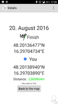
| Sat 20 Aug 2016 in 48,16: 48.2013648, 16.2970473 geohashing.info google osm bing/os kml crox |
Location
Vienna, 14th district (Penzing) - in a backyard of a housing estate
Participants
- Micsnare -- flying solo!!
Plans
There were no plans really, this was a rather spontaneous hash. It was early Saturday afternoon (around 4pm) when Micsnare was idling on her couch, when all of the sudden the notification of a near-by hash came in. Google Maps quickly revealed that the hash was located next to some military barracks, so this could prove to be difficult. But Micsnare wanted to try this nonetheless. Since hashing solo is most of the time boring, she quickly pinged B2c, but he seemed still convalescent, that's why Micsnare decided to this one on her own.
Expedition
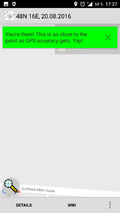
- Yay, it was possible!! -- Micsnare (talk) @48.2014,16.2971 17:29, 20 August 2016 (GMT+02:00)
As mentioned earlier the hashpoint was next to a military barracks, but after having checked Google Maps (Satellite view) it seemed to be in some backyard/garden. Micsnare got on her red Vespa GTS and drove to the closest point possible. Arriving at the hashsite she could see that the hashpoint was still 2 kilometers away, and decided to walk the rest of it on a pavement that led to a housing area.
After having passed that military barracks she knew that the hashpoint must be directly behind the housing area, accessible by the public. Yipeeee!
The housing area was quiet and not busy at all, which is obviously the best condition for hashing. The hashsite was beautiful, probably one of the nicest locations to enjoy the nice weather. The weather was sunny and almost 30° Celcius, which is quite warm.
After doing the little hashdance and taking some pictures and posting them to the wiki, Micsnare happily made her way back to the hashbike.
It's better to let the pictures speak for themselves.... enjoy!
Tracklog
No tracklog this time, because Micsnare forgot to start the tracking when she left the house -- sorry :(
Photos
- Photo Gallery

Stupid Grin(tm) @48.2014,16.2970
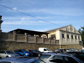
View of the miliary barracks from outside
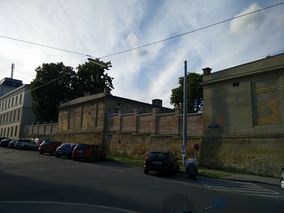
different angle of the miliary barracks
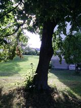
directly on the hashpoint
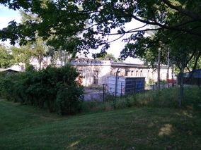
view from the hashpoint to those barracks

lovely backyard, lovely weather
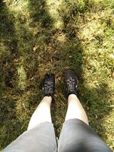
Micsnare's feet on the hashpoint
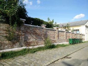
outside of the wall ....
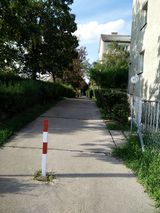
Entry to the housing estate

another of Micsnare's stupid grins
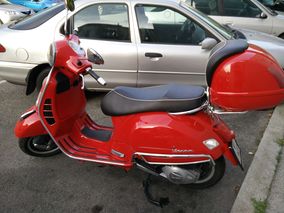
her vehicle of choice to drive to the hashsite

aren't they cute? <3
Proof.
More Proof.


