Difference between revisions of "2016-08-21 54 -118"
From Geohashing
imported>FippeBot m (Location) |
m (per Renaming Proposal) |
||
| (One intermediate revision by one other user not shown) | |||
| Line 53: | Line 53: | ||
<!-- Add any achievement ribbons you earned below, or remove this section --> | <!-- Add any achievement ribbons you earned below, or remove this section --> | ||
| − | {{ | + | {{Graticule unlocked |
| latitude = 54 | | latitude = 54 | ||
| longitude = -118 | | longitude = -118 | ||
| Line 69: | Line 69: | ||
[[Category:Expeditions with photos]] | [[Category:Expeditions with photos]] | ||
| − | {{location|CA|AB}} | + | {{location|CA|AB|GV}} |
Latest revision as of 04:59, 20 March 2024
| Sun 21 Aug 2016 in 54,-118: 54.4923943, -118.7350583 geohashing.info google osm bing/os kml crox |

Location
Just of Hwy 40, 3km into the Husky Road, 250m north of the road in the woods
Participants
Plans
found this point on our route from the Yukon south while checking at the tourist info in Dawson creek. Plans, make lunch stop. hash, done.
Expedition
It was a bit wet and rainy, so it took some convincing to get my friends out. but we made it
Photos
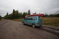
muddy roads there
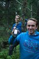
dragged along friends


Achievements
Wijnland, Rogier earned the Graticule Unlocked Achievement
|