Difference between revisions of "2016-09-11 51 6"
imported>Pah |
imported>FippeBot m (Location) |
||
| (2 intermediate revisions by one other user not shown) | |||
| Line 13: | Line 13: | ||
== Participants == | == Participants == | ||
| − | * [[User:Pah|pah]] [[File:U+110DB.png|middle|6px|link=User:Pah]] ([[2016-08-08 51 7|prev]]|next) | + | * [[User:Pah|pah]] [[File:U+110DB.png|middle|6px|link=User:Pah]] ([[2016-08-08 51 7|prev]]|[[2016-12-10 51 6|next]]) |
* NB | * NB | ||
| Line 55: | Line 55: | ||
[[Category:Expeditions with photos]] | [[Category:Expeditions with photos]] | ||
[[Category:Coordinates reached]] | [[Category:Coordinates reached]] | ||
| + | {{location|DE|NW|GV}} | ||
Latest revision as of 02:10, 7 August 2019
| Sun 11 Sep 2016 in 51,6: 51.3236616, 6.6997710 geohashing.info google osm bing/os kml crox |
Location
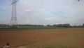
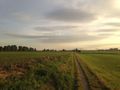
On a harvested salad field in Meerbusch.
Participants
Expedition
On a beautiful late summer day and after fixing pah ![]() 's bicycle, NB and pah went for their first bicycle geohash. After a trip of 16 km mostly along the river Rhine, they arrived near the hashpoint on a harvested and ploughed salad field near Meerbusch.
's bicycle, NB and pah went for their first bicycle geohash. After a trip of 16 km mostly along the river Rhine, they arrived near the hashpoint on a harvested and ploughed salad field near Meerbusch.
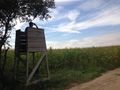
After reaching the hashpoint, they built a mark and took some pictures and the necessary proof. On a nearby hunting hide, they then had a small picnic (chips and beer), unfortunately lacking the required accessories to claim a Picnic achievement. On their way home, they crossed the river Rhine by ferry and enjoyed the sunset in a nice beer garden in Kaiserswerth. All in all, the geohash expedition was a nice 30 km cycling through the beautiful countryside along the river.
Photos
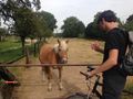
Hashpony
Looking towards the hash
View towards the hash
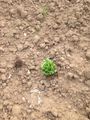
Forgotten salad near the hash
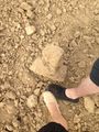
Hash marker and mandatory feet
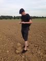
Taking proof at the marker
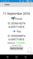
Proof
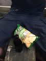
"Picnic"
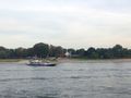
Waiting for the ferry
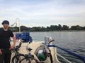
On the ferry
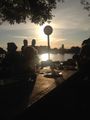
In the beer garden
On the way home (with an Emirates A380 approaching DUS)


Achievements
pah
|