Difference between revisions of "2016-09-29 52 0"
imported>Tongs |
m |
||
| (6 intermediate revisions by 2 users not shown) | |||
| Line 21: | Line 21: | ||
<!-- where you've surveyed the hash to be --> | <!-- where you've surveyed the hash to be --> | ||
| − | Near Beechwoods Nature Reserve, Great Shelford. | + | Near [http://www.wildlifebcn.org/reserves/beechwoods Beechwoods Nature Reserve], Great Shelford. |
== Participants == | == Participants == | ||
| Line 27: | Line 27: | ||
--> | --> | ||
| − | * Tongs/B. | + | * [[User:Tongs/B|Tongs/B]]. |
== Plans == | == Plans == | ||
<!-- what were the original plans --> | <!-- what were the original plans --> | ||
| + | |||
| + | This looks like a pretty little nature reserve, and in easy walking distance of the Park and Ride. I'm thinking of going for a walk to explore it after work, just before [http://www.timeanddate.com/astronomy/uk/cambridge sunset], so something like 5pm or 6pm. I'm quite flexible with times, though, so if anyone wants to come along, I can probably meet you, if you'd like that. | ||
| + | |||
| + | Other Tongs are unlikely to be able to make it. | ||
| + | |||
| + | '''Update''': I'm heading out in a bit (around 5pm), so I should be around there at 6pm or just before. | ||
== Expedition == | == Expedition == | ||
| − | + | ||
| + | Only a few miles from my house, the hash point was easy to get to because it was a short walk from Babraham Road Park and Ride. This expedition was one of those that make you realise why you’re geohashing in the first place, because the nature reserve was one of those hidden-away, beautiful little places. | ||
| + | |||
| + | The journey was easy. I caught the bus from the station and walked out of the side exit of the Park and Ride and along a road with altogether too little room at the sides. I could walk over nettles and straight into the field, which had been ploughed and seeded with grass. Finding the point was easy - I got to it just before 6pm as planned. | ||
| + | |||
| + | Continuing in the same direction, I found a little path which led to the Beechwoods reserve. Nobody else was there and I wandered among the trees. They looked particularly nice at sunset. I did a few laps of the reserve, along different paths, and went back along the path to the Park and Ride. I think I’ll go back there one day with a picnic. | ||
== Tracklog == | == Tracklog == | ||
| − | + | ||
| + | To come. | ||
== Photos == | == Photos == | ||
| + | |||
| + | To come. | ||
| + | |||
<!-- Insert pictures between the gallery tags using the following format: | <!-- Insert pictures between the gallery tags using the following format: | ||
Image:2012-##-## ## ## Alpha.jpg | Witty Comment | Image:2012-##-## ## ## Alpha.jpg | Witty Comment | ||
| Line 49: | Line 64: | ||
<!-- Add any achievement ribbons you earned below, or remove this section --> | <!-- Add any achievement ribbons you earned below, or remove this section --> | ||
| − | |||
| − | |||
| − | |||
| − | |||
| − | |||
| − | |||
| − | |||
| − | |||
| − | |||
| − | |||
| − | |||
| − | |||
| − | |||
| − | |||
[[Category:Expeditions]] | [[Category:Expeditions]] | ||
| − | -- and one or more of -- | + | [[Category:Coordinates reached]] |
| + | <!-- and one or more of -- | ||
[[Category:Expeditions with photos]] | [[Category:Expeditions with photos]] | ||
[[Category:Expeditions with videos]] | [[Category:Expeditions with videos]] | ||
[[Category:Expedition without GPS]] | [[Category:Expedition without GPS]] | ||
--> | --> | ||
| − | |||
| − | |||
| − | |||
| + | == Retrohash revisit on 2017-05-07 == | ||
| + | |||
| + | Jules had just got a new car, and he wanted to go for a drive. We set off and just drove, without planning any particular destination. I noticed we were nearing the Park and Ride, and I suggested we stop and visit the reserve again. We parked in a nearly empty car park, and walked over, talking about life. On the way, we went to visit the hashpoint from months ago, but the field had been sown with a crop, so we got as close as we could by walking where the crop wasn't. A hut (or hide) had been built very near the hashpoint since I had last visited. | ||
| + | |||
| + | I explained to Jules what geohashing was all about, and we went for a walk around the woods. When we got back to the car, we faffed around working out whether we needed to pay for parking or not. The parking machine said no, but only after I had paid. Its screen shows the image that the ANPR took. I thought that was pretty cool. I think we went back to Jules's house and played virtual reality games for a bit. | ||
| − | -- | + | <gallery perrow="5"> |
| − | + | Image:2016-09-29 52 0 retro-1.jpg | Back again, this time with Jules. | |
| − | + | Image:2016-09-29 52 0 retro-2.jpg | A hut appears. | |
| − | + | Image:2016-09-29 52 0 retro-3.jpg | The mystery crop. | |
| − | + | </gallery> | |
| − | |||
| − | |||
| − | |||
| − | + | [[Category:Retro meetup]] | |
| − | [[Category: | + | [[Category:Retro coordinates reached]] |
| − | |||
| − | |||
| − | [[Category: | ||
| − | + | {{location|GB|ENG|CAM}} | |
Latest revision as of 19:12, 11 September 2021
| Thu 29 Sep 2016 in 52,0: 52.1712655, 0.1665137 geohashing.info google osm bing/os kml crox |
Location
Near Beechwoods Nature Reserve, Great Shelford.
Participants
Plans
This looks like a pretty little nature reserve, and in easy walking distance of the Park and Ride. I'm thinking of going for a walk to explore it after work, just before sunset, so something like 5pm or 6pm. I'm quite flexible with times, though, so if anyone wants to come along, I can probably meet you, if you'd like that.
Other Tongs are unlikely to be able to make it.
Update: I'm heading out in a bit (around 5pm), so I should be around there at 6pm or just before.
Expedition
Only a few miles from my house, the hash point was easy to get to because it was a short walk from Babraham Road Park and Ride. This expedition was one of those that make you realise why you’re geohashing in the first place, because the nature reserve was one of those hidden-away, beautiful little places.
The journey was easy. I caught the bus from the station and walked out of the side exit of the Park and Ride and along a road with altogether too little room at the sides. I could walk over nettles and straight into the field, which had been ploughed and seeded with grass. Finding the point was easy - I got to it just before 6pm as planned.
Continuing in the same direction, I found a little path which led to the Beechwoods reserve. Nobody else was there and I wandered among the trees. They looked particularly nice at sunset. I did a few laps of the reserve, along different paths, and went back along the path to the Park and Ride. I think I’ll go back there one day with a picnic.
Tracklog
To come.
Photos
To come.
Achievements
Retrohash revisit on 2017-05-07
Jules had just got a new car, and he wanted to go for a drive. We set off and just drove, without planning any particular destination. I noticed we were nearing the Park and Ride, and I suggested we stop and visit the reserve again. We parked in a nearly empty car park, and walked over, talking about life. On the way, we went to visit the hashpoint from months ago, but the field had been sown with a crop, so we got as close as we could by walking where the crop wasn't. A hut (or hide) had been built very near the hashpoint since I had last visited.
I explained to Jules what geohashing was all about, and we went for a walk around the woods. When we got back to the car, we faffed around working out whether we needed to pay for parking or not. The parking machine said no, but only after I had paid. Its screen shows the image that the ANPR took. I thought that was pretty cool. I think we went back to Jules's house and played virtual reality games for a bit.
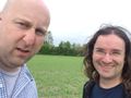
Back again, this time with Jules.
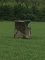
A hut appears.
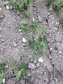
The mystery crop.


