Difference between revisions of "2016-10-02 49 8"
imported>DODO (Created page with "{{subst:Expedition |lat = 49 |lon = 8 |date = 2016-10-02 }}") |
imported>FippeBot m (Location) |
||
| (8 intermediate revisions by one other user not shown) | |||
| Line 20: | Line 20: | ||
== Location == | == Location == | ||
<!-- where you've surveyed the hash to be --> | <!-- where you've surveyed the hash to be --> | ||
| + | The forest near Dudenhofen, just 3,5 kilometers from [[User:DODO|DODOs]] home. | ||
== Participants == | == Participants == | ||
<!-- who attended: If you link to your wiki user name in this section, your expedition will be picked up by the various statistics generated for geohashing. You may use three tildes ~ as a shortcut to automatically insert the user signature of the account you are editing with. | <!-- who attended: If you link to your wiki user name in this section, your expedition will be picked up by the various statistics generated for geohashing. You may use three tildes ~ as a shortcut to automatically insert the user signature of the account you are editing with. | ||
--> | --> | ||
| + | [[User:DODO|DODO]] | ||
== Plans == | == Plans == | ||
<!-- what were the original plans --> | <!-- what were the original plans --> | ||
| + | A hash just to close, not to go. Walk there, trying to tron the way. | ||
== Expedition == | == Expedition == | ||
<!-- how it all turned out. your narrative goes here. --> | <!-- how it all turned out. your narrative goes here. --> | ||
| + | Started at home at 12:30. Just an 9 kilometers walk. The most parts were pretty easy, I even reached the hash 10 meters apart from the way and returned to the path without crossing my way (and got an1,6m without any dancing). Things became a little more difficult when I crossed a street and the way on the other side just wasn't there, but the forest was unobstructed and so I just crossed it until I reached another path. After 90 minutes I reached home again. | ||
== Tracklog == | == Tracklog == | ||
<!-- if your GPS device keeps a log, you may post a link here --> | <!-- if your GPS device keeps a log, you may post a link here --> | ||
| + | [https://www.komoot.de/tour/12819879 9 KM by foot] | ||
== Photos == | == Photos == | ||
| Line 38: | Line 43: | ||
Image:2012-##-## ## ## Alpha.jpg | Witty Comment | Image:2012-##-## ## ## Alpha.jpg | Witty Comment | ||
--> | --> | ||
| − | <gallery perrow=" | + | Oh my god, I always forget how crappy the camera of the tablet is. Sorry for that. |
| + | |||
| + | <gallery perrow="4"> | ||
| + | Image:2016-10-02_49_8-1.jpg|I crossed the graveyard in Dudenhofen and found this war memorial | ||
| + | Image:2016-10-02_49_8-7.png|proof | ||
| + | Image:2016-10-02_49_8-2.jpg|one direction | ||
| + | Image:2016-10-02_49_8-3.jpg|another | ||
| + | Image:2016-10-02_49_8-4.jpg|pretty much the same in this direction | ||
| + | Image:2016-10-02_49_8-5.jpg|and this direction in upright format | ||
| + | Image:2016-10-02_49_8-6.jpg|a hashers grin | ||
</gallery> | </gallery> | ||
| Line 44: | Line 58: | ||
{{#vardefine:ribbonwidth|800px}} | {{#vardefine:ribbonwidth|800px}} | ||
<!-- Add any achievement ribbons you earned below, or remove this section --> | <!-- Add any achievement ribbons you earned below, or remove this section --> | ||
| + | {{land geohash | ||
| + | |||
| + | | latitude = 49 | ||
| + | | longitude = 8 | ||
| + | | date = 2016-10-02 | ||
| + | | name = DODO | ||
| + | }} | ||
| − | + | {{Walk geohash | |
| − | + | | latitude = 49 | |
| − | + | | longitude = 8 | |
| + | | date = 2016-10-02 | ||
| + | | name = DODO | ||
| + | | distance = 9 KM | ||
| + | }} | ||
| − | + | {{Template:Tron | |
| + | | latitude = 49 | ||
| + | | longitude = 8 | ||
| + | | date = 2016-10-02 | ||
| + | | name = DODO | ||
| + | | possessive = his | ||
| + | | tracklog = https://www.komoot.de/tour/12819879 | ||
| + | }} | ||
| − | + | {{OpenStreetMap achievement | |
| − | + | | latitude = 49 | |
| − | + | | longitude = 8 | |
| − | + | | date = 2016-10-02 | |
| + | | OSMlink = 42589975 | ||
| + | | name = DODO | ||
| + | }} | ||
| − | |||
| − | |||
[[Category:Expeditions]] | [[Category:Expeditions]] | ||
| − | |||
[[Category:Expeditions with photos]] | [[Category:Expeditions with photos]] | ||
| − | |||
| − | |||
| − | |||
| − | |||
| − | |||
[[Category:Coordinates reached]] | [[Category:Coordinates reached]] | ||
| − | + | {{location|DE|RP|RP}} | |
| − | |||
| − | |||
| − | |||
| − | |||
| − | |||
| − | |||
| − | |||
| − | |||
| − | |||
| − | |||
| − | |||
| − | |||
| − | |||
| − | |||
| − | |||
| − | |||
| − | |||
Latest revision as of 01:33, 16 August 2019
| Sun 2 Oct 2016 in 49,8: 49.3241238, 8.3752673 geohashing.info google osm bing/os kml crox |
Location
The forest near Dudenhofen, just 3,5 kilometers from DODOs home.
Participants
Plans
A hash just to close, not to go. Walk there, trying to tron the way.
Expedition
Started at home at 12:30. Just an 9 kilometers walk. The most parts were pretty easy, I even reached the hash 10 meters apart from the way and returned to the path without crossing my way (and got an1,6m without any dancing). Things became a little more difficult when I crossed a street and the way on the other side just wasn't there, but the forest was unobstructed and so I just crossed it until I reached another path. After 90 minutes I reached home again.
Tracklog
Photos
Oh my god, I always forget how crappy the camera of the tablet is. Sorry for that.
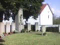
I crossed the graveyard in Dudenhofen and found this war memorial
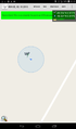
proof
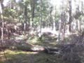
one direction
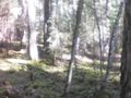
another
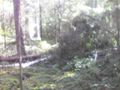
pretty much the same in this direction
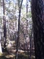
and this direction in upright format

a hashers grin


Achievements
DODO earned the Land geohash achievement
|
DODO earned the Walk geohash Achievement
|
DODO earned the Tron achievement
|
DODO earned the OpenStreetMap achievement
|