Difference between revisions of "2016-10-03 38 35"
imported>Kozz (Created page with "{{subst:Expedition |lat = 38 |lon = 35 |date = 2016-10-03 }}") |
m (Category) |
||
| (10 intermediate revisions by 3 users not shown) | |||
| Line 15: | Line 15: | ||
}} | }} | ||
| − | + | ||
__NOTOC__ | __NOTOC__ | ||
== Location == | == Location == | ||
| − | + | In a field outside of Kayseri, Turkey | |
== Participants == | == Participants == | ||
| − | + | * [[User:Kozz|Kozz]], | |
| − | + | * extended family, | |
| + | * driver | ||
== Plans == | == Plans == | ||
| − | + | None | |
== Expedition == | == Expedition == | ||
| − | + | This has got to be one of the daftest things I've not done. My extended family had three weeks in Turkey and we went a whole bunch of places, including Urgup in Cappadocia. 10/10 would do again. | |
| + | |||
| + | We were transiting from Urgup, which is not far away from Kayseri, through to Kayseri then onto Istanbul. | ||
| + | |||
| + | We had a driver who spoke Turkish and all we had to do was get to the airport in Kayseri by midday. | ||
| − | + | I had been checking geohashes whenever we had internet. I didn't have a data plan on my phone but there was a computer where we were staying so I could've easily checked...but you know, packing bags, having breakfast, saying goodbye to everyone...by the time it was time to load up the minivan I'd completely forgotten. | |
| − | |||
| − | + | Long story short we passed within 3km of the hashpoint. I've got two photos and videos which have loose GPS fixes on them, and can compare these to Street View to get a decent fix on where we were. So I have a photo which is taken 6ish km from the hashpoint pointing at the hashpoint. | |
| − | |||
| − | |||
| − | |||
| − | |||
| − | |||
| − | + | Route: We drove along the D300 from Urgup to Kayseri. From memory, it was a very hazy morning. The driver told us that the mountain, Mount Erciyes (visible in pictures) has snow on it perenially - it's the highest peak in Cappadocia. The hashpoint was pretty much in a straight line between us and the mountain. Where we turned to follow the D300, had we continued straight for 3.2km and stayed on the main road, we'd have been about 500m away. If we'd taken the side road it would've been | |
| − | |||
| − | |||
| − | + | Obviously can't claim this one but interesting to know it was there. We drove through the cloverleaf intersection to stay on the D300 so measuring that distance it's about 2 miles. Wow. Just...wow. Travel half a world away and drive straight past the hashpoint! | |
| − | |||
| − | |||
| − | + | ---- | |
| − | |||
| − | |||
| − | |||
| − | |||
| − | + | == Photos == | |
| − | < | + | <gallery perrow="5"> |
| − | + | Image:2015-10-03-38-35.jpg | The Story | |
| − | -- | + | </gallery> |
| − | |||
| − | |||
| − | |||
| − | |||
| − | |||
| − | |||
| − | |||
| + | == Achievements == | ||
| − | |||
| − | |||
| − | |||
| − | |||
| − | |||
| − | |||
| − | |||
| − | |||
| − | + | {{Curse of Unawareness | |
| − | + | | latitude = 38 | |
| − | + | | longitude = 35 | |
| − | + | | date = 2016-10-03 | |
| − | [[ | + | | name = [[User:Kozz|Kozz]] |
| + | }} | ||
| − | + | [[Category:Not reached - Did not attempt]] | |
| + | {{location|TR|38}} | ||
Latest revision as of 21:19, 13 December 2022
| Mon 3 Oct 2016 in 38,35: 38.6627550, 35.2654170 geohashing.info google osm bing/os kml crox |
Location
In a field outside of Kayseri, Turkey
Participants
- Kozz,
- extended family,
- driver
Plans
None
Expedition
This has got to be one of the daftest things I've not done. My extended family had three weeks in Turkey and we went a whole bunch of places, including Urgup in Cappadocia. 10/10 would do again.
We were transiting from Urgup, which is not far away from Kayseri, through to Kayseri then onto Istanbul.
We had a driver who spoke Turkish and all we had to do was get to the airport in Kayseri by midday.
I had been checking geohashes whenever we had internet. I didn't have a data plan on my phone but there was a computer where we were staying so I could've easily checked...but you know, packing bags, having breakfast, saying goodbye to everyone...by the time it was time to load up the minivan I'd completely forgotten.
Long story short we passed within 3km of the hashpoint. I've got two photos and videos which have loose GPS fixes on them, and can compare these to Street View to get a decent fix on where we were. So I have a photo which is taken 6ish km from the hashpoint pointing at the hashpoint.
Route: We drove along the D300 from Urgup to Kayseri. From memory, it was a very hazy morning. The driver told us that the mountain, Mount Erciyes (visible in pictures) has snow on it perenially - it's the highest peak in Cappadocia. The hashpoint was pretty much in a straight line between us and the mountain. Where we turned to follow the D300, had we continued straight for 3.2km and stayed on the main road, we'd have been about 500m away. If we'd taken the side road it would've been
Obviously can't claim this one but interesting to know it was there. We drove through the cloverleaf intersection to stay on the D300 so measuring that distance it's about 2 miles. Wow. Just...wow. Travel half a world away and drive straight past the hashpoint!
Photos
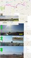
The Story

Achievements
Kozz earned the Curse of Unawareness Consolation Prize
|