Difference between revisions of "2016-10-20 49 8"
imported>DODO (→Plans) |
imported>FippeBot m (Location) |
||
| (5 intermediate revisions by one other user not shown) | |||
| Line 33: | Line 33: | ||
== Expedition == | == Expedition == | ||
<!-- how it all turned out. your narrative goes here. --> | <!-- how it all turned out. your narrative goes here. --> | ||
| + | Well, if you've read some of my reports you'll already know, that I won't wait long. I just drove there on my way to the office. It was the last road in the harbour and only trucks were driving there. And my very little car. I parked the car 80 meters from the hash and walked along the fence, not sure on which side of it I would find the hash. It just started to rain so I hurried a little bit. I came up to 2,6 m, inside the uncertainty and decided this is good enough (given the fact that gps first located me on the other side of the road). It was still quit dark and rainy, so most pictures I took were crap. Then I drove back to the office. | ||
| + | |||
| + | Almost to easy. | ||
== Tracklog == | == Tracklog == | ||
<!-- if your GPS device keeps a log, you may post a link here --> | <!-- if your GPS device keeps a log, you may post a link here --> | ||
| + | No track log this time. But - just for the statistics - an 8 kilometers detour on my way to the office. | ||
== Photos == | == Photos == | ||
| Line 42: | Line 46: | ||
--> | --> | ||
<gallery perrow="5"> | <gallery perrow="5"> | ||
| + | Image:2016-10-23_49_8-1.jpg|view from the hash to the north | ||
| + | Image:2016-10-23_49_8-2.jpg|and to the south (one of the trucks is approaching | ||
| + | Image:2016-10-23_49_8-3.jpg|hasher | ||
| + | Image:2016-10-23_49_8-4.png|proof | ||
</gallery> | </gallery> | ||
| Line 48: | Line 56: | ||
<!-- Add any achievement ribbons you earned below, or remove this section --> | <!-- Add any achievement ribbons you earned below, or remove this section --> | ||
| − | |||
| − | |||
| − | |||
| − | + | {{land geohash | |
| + | | latitude = 49 | ||
| + | | longitude = 8 | ||
| + | | date = 2016-10-20 | ||
| + | | name = DODO | ||
| + | }} | ||
| − | |||
| − | |||
| − | |||
| − | |||
| − | |||
| − | |||
| − | |||
| − | |||
[[Category:Expeditions]] | [[Category:Expeditions]] | ||
| − | |||
| − | |||
| − | |||
| − | |||
| − | |||
| − | |||
| − | |||
[[Category:Coordinates reached]] | [[Category:Coordinates reached]] | ||
| − | + | {{location|DE|BW|MA}} | |
| − | |||
| − | |||
| − | |||
| − | |||
| − | |||
| − | |||
| − | |||
| − | |||
| − | |||
| − | |||
| − | |||
| − | |||
| − | |||
| − | |||
| − | |||
| − | |||
| − | |||
Latest revision as of 01:37, 16 August 2019
| Thu 20 Oct 2016 in 49,8: 49.4239857, 8.5075865 geohashing.info google osm bing/os kml crox |
Location
Next to a fence in the harbor of Mannheim-Rheinau.
Participants
Plans
It is just 4 Kilometers from my office and I had to go to work by car anyway. So I'll just take my tablet with me and go there whenever I have time.
Expedition
Well, if you've read some of my reports you'll already know, that I won't wait long. I just drove there on my way to the office. It was the last road in the harbour and only trucks were driving there. And my very little car. I parked the car 80 meters from the hash and walked along the fence, not sure on which side of it I would find the hash. It just started to rain so I hurried a little bit. I came up to 2,6 m, inside the uncertainty and decided this is good enough (given the fact that gps first located me on the other side of the road). It was still quit dark and rainy, so most pictures I took were crap. Then I drove back to the office.
Almost to easy.
Tracklog
No track log this time. But - just for the statistics - an 8 kilometers detour on my way to the office.
Photos
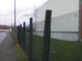
view from the hash to the north
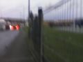
and to the south (one of the trucks is approaching

hasher
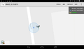
proof


Achievements
DODO earned the Land geohash achievement
|