Difference between revisions of "2016-10-28 49 8"
From Geohashing
imported>DODO (→Plans) |
imported>FippeBot m (Location) |
||
| (6 intermediate revisions by one other user not shown) | |||
| Line 33: | Line 33: | ||
== Expedition == | == Expedition == | ||
<!-- how it all turned out. your narrative goes here. --> | <!-- how it all turned out. your narrative goes here. --> | ||
| + | It was still dark when I drove to work. I left my usual way and continued the drive for four kilometers to the graveyard of Otterstadt. I left the car there and walked 500 meters through a residential area. The hash just lay there on the side of the road on a parking area. I made some pictures but they were all mostly black with some light dots. I returned to the car, drove back to my way to work and that was it. | ||
== Tracklog == | == Tracklog == | ||
<!-- if your GPS device keeps a log, you may post a link here --> | <!-- if your GPS device keeps a log, you may post a link here --> | ||
| + | [https://www.komoot.de/tour/13252725 4 KM by car and 1 KM by foot]. As usual I didn't track the drive back of 4 kilometers.. | ||
== Photos == | == Photos == | ||
| Line 42: | Line 44: | ||
--> | --> | ||
<gallery perrow="5"> | <gallery perrow="5"> | ||
| + | Image:2016-10-28_49_8-1.jpg|grin in the dark | ||
| + | Image:2016-10-28_49_8-2.png|proof | ||
</gallery> | </gallery> | ||
== Achievements == | == Achievements == | ||
| − | |||
| − | |||
| − | + | {{land geohash | |
| − | + | | latitude = 49 | |
| − | + | | longitude = 8 | |
| + | | date = 2016-10-28 | ||
| + | | name = DODO | ||
| + | }} | ||
| − | + | {{consecutive geohash | |
| + | | count = 2 | ||
| + | | latitude = 49 | ||
| + | | longitude = 8 | ||
| + | | date = 2016-10-27 | ||
| + | | name = DODO | ||
| + | }} | ||
| − | |||
| − | |||
| − | |||
| − | |||
| − | |||
| − | |||
| − | |||
| − | |||
[[Category:Expeditions]] | [[Category:Expeditions]] | ||
| − | |||
| − | |||
| − | |||
| − | |||
| − | |||
| − | |||
| − | |||
[[Category:Coordinates reached]] | [[Category:Coordinates reached]] | ||
| − | + | {{location|DE|RP|RP}} | |
| − | |||
| − | |||
| − | |||
| − | |||
| − | |||
| − | |||
| − | |||
| − | |||
| − | |||
| − | |||
| − | |||
| − | |||
| − | |||
| − | |||
| − | |||
| − | |||
| − | |||
Latest revision as of 01:40, 16 August 2019
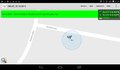
| Fri 28 Oct 2016 in 49,8: 49.3761244, 8.4524936 geohashing.info google osm bing/os kml crox |
Location
A street in Otterstadt.
Participants
Plans
Once again to close not to go. I'll try to go there on my way to work tomorrow morning.
Expedition
It was still dark when I drove to work. I left my usual way and continued the drive for four kilometers to the graveyard of Otterstadt. I left the car there and walked 500 meters through a residential area. The hash just lay there on the side of the road on a parking area. I made some pictures but they were all mostly black with some light dots. I returned to the car, drove back to my way to work and that was it.
Tracklog
4 KM by car and 1 KM by foot. As usual I didn't track the drive back of 4 kilometers..
Photos

grin in the dark
proof


Achievements
DODO earned the Land geohash achievement
|
DODO earned the Consecutive geohash achievement
|