Difference between revisions of "2016-12-05 51 9"
From Geohashing
imported>GeorgDerReisende (new report) |
imported>FippeBot m (Location) |
||
| (One intermediate revision by one other user not shown) | |||
| Line 1: | Line 1: | ||
| − | |||
| − | |||
| − | |||
| − | |||
| − | |||
| − | |||
| − | |||
| − | |||
| − | |||
| − | |||
{{meetup graticule | {{meetup graticule | ||
| lat=51 | | lat=51 | ||
| Line 19: | Line 9: | ||
== Location == | == Location == | ||
| − | + | ||
| + | The hash lay on a field at Niederkaufungen. | ||
== Participants == | == Participants == | ||
| − | + | ||
| − | + | [[User:GeorgDerReisende|GeorgDerReisende]] | |
== Plans == | == Plans == | ||
| − | + | ||
| + | Taking the tram to Niederkaufungen, walking to the hash, walking back to Kassel. | ||
== Expedition == | == Expedition == | ||
| − | |||
| − | + | I took the tram to Niederkaufungen and walked to the hash. Instead of walking to Kassel, I made it by hitchhiking, because all the footpaths were freezing. | |
| − | |||
== Photos == | == Photos == | ||
| Line 39: | Line 29: | ||
--> | --> | ||
<gallery perrow="5"> | <gallery perrow="5"> | ||
| + | Image:2016-12-05 51 9 GeorgDerReisende 2420.jpg | arrived by tram | ||
| + | Image:2016-12-05 51 9 GeorgDerReisende 2423.jpg | walking to the hash | ||
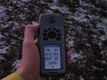
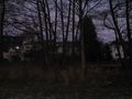
| + | Image:2016-12-05 51 9 GeorgDerReisende 2426.jpg | eight meters to go, but hey, there is a tractor lane | ||
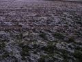
| + | Image:2016-12-05 51 9 GeorgDerReisende 2428.jpg | arrived | ||
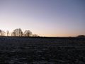
| + | Image:2016-12-05 51 9 GeorgDerReisende 2429.jpg | the north | ||
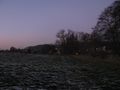
| + | Image:2016-12-05 51 9 GeorgDerReisende 2430.jpg | the west | ||
| + | Image:2016-12-05 51 9 GeorgDerReisende 2431.jpg | the south, and the moon | ||
| + | Image:2016-12-05 51 9 GeorgDerReisende 2432.jpg | the east | ||
| + | Image:2016-12-05 51 9 GeorgDerReisende 2433.jpg | the geohasher | ||
</gallery> | </gallery> | ||
| Line 45: | Line 44: | ||
<!-- Add any achievement ribbons you earned below, or remove this section --> | <!-- Add any achievement ribbons you earned below, or remove this section --> | ||
| − | + | {{Public transport geohash | latitude = 51 | longitude = 9 | date = 2016-12-05 | busline = tram 4 | name = GeorgDerReisende }} | |
| − | |||
| − | |||
| − | + | [[Category:Expeditions]] | |
| − | + | [[Category:Expeditions with photos]] | |
| − | |||
| − | [[Category: | ||
| − | |||
| − | |||
| − | |||
| − | |||
| − | |||
| − | |||
| − | |||
| − | |||
| − | |||
| − | |||
| − | |||
| − | |||
[[Category:Coordinates reached]] | [[Category:Coordinates reached]] | ||
| − | + | {{location|DE|HE|KS}} | |
| − | |||
| − | |||
| − | |||
| − | |||
| − | |||
| − | |||
| − | |||
| − | |||
| − | |||
| − | |||
| − | |||
| − | |||
| − | |||
| − | |||
| − | |||
| − | |||
| − | |||
Latest revision as of 01:50, 16 August 2019
| Mon 5 Dec 2016 in 51,9: 51.2814757, 9.5953862 geohashing.info google osm bing/os kml crox |
Location
The hash lay on a field at Niederkaufungen.
Participants
Plans
Taking the tram to Niederkaufungen, walking to the hash, walking back to Kassel.
Expedition
I took the tram to Niederkaufungen and walked to the hash. Instead of walking to Kassel, I made it by hitchhiking, because all the footpaths were freezing.
Photos
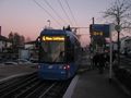
arrived by tram
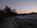
walking to the hash
eight meters to go, but hey, there is a tractor lane
arrived
the north
the west
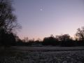
the south, and the moon
the east
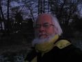
the geohasher


Achievements
GeorgDerReisende earned the Public transport geohash achievement
|