Difference between revisions of "2016-12-17 49 8"
imported>DODO (Created page with "{{subst:Expedition |lat = 49 |lon = 8 |date = 2016-12-17 }}") |
imported>FippeBot m (Location) |
||
| (2 intermediate revisions by one other user not shown) | |||
| Line 20: | Line 20: | ||
== Location == | == Location == | ||
<!-- where you've surveyed the hash to be --> | <!-- where you've surveyed the hash to be --> | ||
| + | In the Lampertheimer Forest between Lampertheim and Viernheim. | ||
== Participants == | == Participants == | ||
<!-- who attended: If you link to your wiki user name in this section, your expedition will be picked up by the various statistics generated for geohashing. You may use three tildes ~ as a shortcut to automatically insert the user signature of the account you are editing with. | <!-- who attended: If you link to your wiki user name in this section, your expedition will be picked up by the various statistics generated for geohashing. You may use three tildes ~ as a shortcut to automatically insert the user signature of the account you are editing with. | ||
--> | --> | ||
| − | + | [[User:DODO|DODO]] | |
== Plans == | == Plans == | ||
<!-- what were the original plans --> | <!-- what were the original plans --> | ||
| − | + | Go there by bull. | |
== Expedition == | == Expedition == | ||
<!-- how it all turned out. your narrative goes here. --> | <!-- how it all turned out. your narrative goes here. --> | ||
| + | It was cold and grey outside and I wasn't sure if I should go hashing, or rowing or shopping (still need some X-mas presents). But in the end it looks like it ends sitting home all day and waiting for the day to pass by. And to afford that, I started in the early afternoon (12:45). | ||
| + | |||
| + | It was a long, cold and not very interesting tour to the hash riding a long time through the cities of Ludwigshafen and Mannheim. When I finally reached the forest the road was very bad and I had to drive slowly . But then I was near the hash. Exactly when I locked the bull, it started to rain. The hash was only 140 meters into the light forest. I had a quick walk, took some necessary photos and returned to the bull. A short time after I was riding again the rain stopped. I tried not to cross my way but there were two bridges, where I had to, and so I didn't achieve a tron. On my way home, close to my office, I had a short stop to eat something. I came back home at 16:20 after an 81-kilometer ride, just before it turned dark. | ||
== Tracklog == | == Tracklog == | ||
<!-- if your GPS device keeps a log, you may post a link here --> | <!-- if your GPS device keeps a log, you may post a link here --> | ||
| − | + | [https://www.komoot.de/tour/13706253 81 km bullriding] | |
== Photos == | == Photos == | ||
<!-- Insert pictures between the gallery tags using the following format: | <!-- Insert pictures between the gallery tags using the following format: | ||
Image:2012-##-## ## ## Alpha.jpg | Witty Comment | Image:2012-##-## ## ## Alpha.jpg | Witty Comment | ||
--> | --> | ||
| − | <gallery perrow=" | + | <gallery perrow="6"> |
| + | Image:2016-12-17_49_8-1.jpg|view in hash direction (140 m to go, bull in the foreground) | ||
| + | Image:2016-12-17_49_8-6.png|proof | ||
| + | Image:2016-12-17_49_8-2.jpg|view from hash to bull (to far to see) | ||
| + | Image:2016-12-17_49_8-3.jpg|and the opposite direction (the two other directions look just the same) | ||
| + | Image:2016-12-17_49_8-4.jpg|happy grin | ||
| + | Image:2016-12-17_49_8-5.jpg|wet bull | ||
</gallery> | </gallery> | ||
| Line 44: | Line 54: | ||
{{#vardefine:ribbonwidth|800px}} | {{#vardefine:ribbonwidth|800px}} | ||
<!-- Add any achievement ribbons you earned below, or remove this section --> | <!-- Add any achievement ribbons you earned below, or remove this section --> | ||
| + | {{land geohash | ||
| + | | latitude = 49 | ||
| + | | longitude = 8 | ||
| + | | date = 2016-12-17 | ||
| + | | name = DODO | ||
| + | }} | ||
| − | + | [[Category:Expeditions]] | |
| − | |||
| − | [[Category: | ||
| − | |||
| − | |||
| − | |||
| − | |||
| − | |||
| − | |||
| − | |||
| − | |||
| − | |||
| − | |||
| − | |||
| − | |||
| − | |||
| − | |||
| − | |||
| − | |||
| − | |||
| − | |||
[[Category:Coordinates reached]] | [[Category:Coordinates reached]] | ||
| − | + | {{location|DE|HE|HP}} | |
| − | |||
| − | |||
| − | |||
| − | |||
| − | |||
| − | |||
| − | |||
| − | |||
| − | |||
| − | |||
| − | |||
| − | |||
| − | |||
| − | |||
| − | |||
| − | |||
| − | |||
Latest revision as of 01:53, 16 August 2019
| Sat 17 Dec 2016 in 49,8: 49.5675199, 8.5406847 geohashing.info google osm bing/os kml crox |
Location
In the Lampertheimer Forest between Lampertheim and Viernheim.
Participants
Plans
Go there by bull.
Expedition
It was cold and grey outside and I wasn't sure if I should go hashing, or rowing or shopping (still need some X-mas presents). But in the end it looks like it ends sitting home all day and waiting for the day to pass by. And to afford that, I started in the early afternoon (12:45).
It was a long, cold and not very interesting tour to the hash riding a long time through the cities of Ludwigshafen and Mannheim. When I finally reached the forest the road was very bad and I had to drive slowly . But then I was near the hash. Exactly when I locked the bull, it started to rain. The hash was only 140 meters into the light forest. I had a quick walk, took some necessary photos and returned to the bull. A short time after I was riding again the rain stopped. I tried not to cross my way but there were two bridges, where I had to, and so I didn't achieve a tron. On my way home, close to my office, I had a short stop to eat something. I came back home at 16:20 after an 81-kilometer ride, just before it turned dark.
Tracklog
Photos
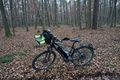
view in hash direction (140 m to go, bull in the foreground)
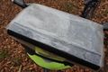
proof
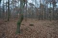
view from hash to bull (to far to see)
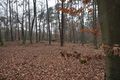
and the opposite direction (the two other directions look just the same)

happy grin
wet bull


Achievements
DODO earned the Land geohash achievement
|