Difference between revisions of "2016-12-30 40 -111"
From Geohashing
imported>Mckaysalisbury (adding images) |
imported>Jiml m (Fix formatting issue - add ribbon indicator) |
||
| Line 13: | Line 13: | ||
== Participants == | == Participants == | ||
| − | * [[User:Mckaysalisbury|McKay]] | + | |
| − | * | + | * [[User:Mckaysalisbury|McKay]] and |
| − | + | * his son | |
| − | |||
== Plans == | == Plans == | ||
| Line 30: | Line 29: | ||
Image:2016-12-30 40 -111 GPS.png | GPS with date | Image:2016-12-30 40 -111 GPS.png | GPS with date | ||
</gallery> | </gallery> | ||
| + | |||
| + | == Achievements == | ||
| + | |||
| + | * Land Geohash | ||
[[Category:Expeditions]] | [[Category:Expeditions]] | ||
[[Category:Expeditions with photos]] | [[Category:Expeditions with photos]] | ||
[[Category:Coordinates reached]] | [[Category:Coordinates reached]] | ||
Revision as of 03:41, 23 October 2017

| Fri 30 Dec 2016 in 40,-111: 40.5320265, -111.9938169 geohashing.info google osm bing/os kml crox |
Location
In Swenson Farms Park, South of the Daybreak community, in west Salt Lake City
Participants
- McKay and
- his son
Plans
Head out there in the afternoon and see some other sights in the area. Like up in Daybreak.
Expedition
It was a gruesome trek through inches of snow! Without a coat. But both my son and I made it!
Photos
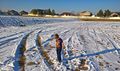
Looking down right where he was told to stand
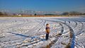
Classic Grin
GPS with date


Achievements
- Land Geohash