Difference between revisions of "2017-01-03 55 37"
From Geohashing
imported>Dunaril |
imported>Dunaril |
||
| Line 1: | Line 1: | ||
| − | |||
| − | |||
| − | |||
| − | |||
| − | |||
| − | |||
| − | |||
| − | |||
| − | |||
{{meetup graticule | {{meetup graticule | ||
| lat=55 | | lat=55 | ||
| Line 19: | Line 10: | ||
== Location == | == Location == | ||
| − | + | Right on a large road just out and North of Moscow, on the way to the Sheremetyevo airport. | |
== Participants == | == Participants == | ||
| − | + | ~ and Katu as irregular geohashers ; Lena and Nataliya as drivers and first time geohashers! | |
| − | |||
== Plans == | == Plans == | ||
| Line 30: | Line 20: | ||
== Expedition == | == Expedition == | ||
| − | |||
*We hit the geohash, according to Geohash Droid. A few pics below are all the proof I have but I definitely got into GPS uncertainty. This is completely crazy! -- [[User:Dunaril|Dunaril]] ([[User talk:Dunaril|talk]]) 12:15, 3 January 2017 (GMT+03:00) | *We hit the geohash, according to Geohash Droid. A few pics below are all the proof I have but I definitely got into GPS uncertainty. This is completely crazy! -- [[User:Dunaril|Dunaril]] ([[User talk:Dunaril|talk]]) 12:15, 3 January 2017 (GMT+03:00) | ||
| Line 51: | Line 40: | ||
<!-- Add any achievement ribbons you earned below, or remove this section --> | <!-- Add any achievement ribbons you earned below, or remove this section --> | ||
| − | |||
| − | |||
| − | |||
| − | |||
| − | |||
| − | |||
| − | |||
| − | |||
| − | |||
| − | |||
| − | |||
[[Category:Expeditions]] | [[Category:Expeditions]] | ||
| − | + | ||
| − | |||
| − | |||
| − | |||
| − | |||
| − | |||
| − | |||
[[Category:Coordinates reached]] | [[Category:Coordinates reached]] | ||
| − | |||
| − | |||
| − | |||
Revision as of 11:50, 3 January 2017
| Tue 3 Jan 2017 in 55,37: 55.8948450, 37.4284865 geohashing.info google osm bing/os kml crox |
Location
Right on a large road just out and North of Moscow, on the way to the Sheremetyevo airport.
Participants
~ and Katu as irregular geohashers ; Lena and Nataliya as drivers and first time geohashers!
Plans
- Attempting a driving geohash. Google Maps indicates it to be on the other side of the road I am currently taking to the airport. It should be within the GPS uncertainty range. -- Dunaril (talk) @55.8646,37.4639 12:04, 3 January 2017 (GMT+03:00)
Expedition
- We hit the geohash, according to Geohash Droid. A few pics below are all the proof I have but I definitely got into GPS uncertainty. This is completely crazy! -- Dunaril (talk) 12:15, 3 January 2017 (GMT+03:00)
Tracklog
Photos
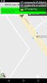
Got it! @55.8991,37.4233

Just before. I hit 0m on Geohash Droid but was too quick to screenshot :) @55.9079,37.4109

