Difference between revisions of "2017-01-04 51 6"
imported>Rincewind (An expedition message sent via Geohash Droid for Android.) |
imported>FippeBot m (Location) |
||
| (14 intermediate revisions by 2 users not shown) | |||
| Line 19: | Line 19: | ||
== Location == | == Location == | ||
| − | + | On a field in Fühlingen, a small town just off my travel route for the day. | |
== Participants == | == Participants == | ||
<!-- who attended: If you link to your wiki user name in this section, your expedition will be picked up by the various statistics generated for geohashing. You may use three tildes ~ as a shortcut to automatically insert the user signature of the account you are editing with. | <!-- who attended: If you link to your wiki user name in this section, your expedition will be picked up by the various statistics generated for geohashing. You may use three tildes ~ as a shortcut to automatically insert the user signature of the account you are editing with. | ||
--> | --> | ||
| + | [[User:Rincewind|Rincewind]] | ||
== Plans == | == Plans == | ||
| − | + | I had a meeting in Düsseldorf yesterday, so I checked the coordinates and they seemed to be very convenient- I had to try to conquer a new graticule. :) | |
| + | My plan was to stop there in the morning, since I had an appointment with a colleague for the gym in the afternoon and time could be tight. | ||
| + | The plan would only work if weather and traffic played nice, though. | ||
== Expedition == | == Expedition == | ||
| − | + | At least traffic played nice... It was constantly raining until I passed Leverkusen, close to the target. This while I always had 2° to 3.5°C in the car display, so I frequently checked the temperature and was a bit nervous considering the way home, because it rained hard enough to wash away any salt solution or whatever winter services used on the roads and I seriously feared driving home on a wet, hilly ice surface. But I had the time for hashing before my appointment, at least. | |
| − | + | The hash coordinates were easy to reach and the weather started to play nice there, too. | |
| − | + | The street next to the field with the hash coordinates was blocked for cars on one side, so I could easily just park at the side. The field was harvested, too, so no risk of damaging winter crops. Walking in, I also discoverd that walking on the large stems of the plants (not sure what they were) minimized sinking into mud- a good thing, since I forgot to pack the dirt shoes. | |
| + | |||
| + | I didn't even have to do a dance, the GPS unit was content with the direction it displayed and walking there, simply counted down to zero. | ||
| + | All in all, a very easy hash in a new graticule, and after a long time of inactivity, too. :) | ||
== Photos == | == Photos == | ||
| Line 39: | Line 45: | ||
--> | --> | ||
<gallery perrow="5"> | <gallery perrow="5"> | ||
| + | |||
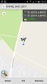
| + | Image:2017-01-04_51_6_Rincewind_1483522442966.jpg|Yay, a new graticule for me. :) [http://www.openstreetmap.org/?lat=51.03288170&lon=6.89924130&zoom=16&layers=B000FTF @51.0329,6.8992] | ||
| + | |||
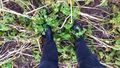
| + | Image:2017-01-04_51_6_Rincewind_1483566112377.jpg|Hash proof | ||
| + | |||
| + | Image:2017-01-04_51_6_Rincewind_1483566230950.jpg|Muddy field hash. | ||
| + | |||
| + | Image:2017-01-04_51_6_Rincewind_1483566298424.jpg|Hash surroundings, two sides of the field were lined with a very big allotment, each small garden seemed to hold its own hut. | ||
| + | |||
| + | Image:Hashproof_scrn.jpg|And GPS coordinates on another gadget... :) | ||
| + | |||
</gallery> | </gallery> | ||
| Line 44: | Line 61: | ||
{{#vardefine:ribbonwidth|800px}} | {{#vardefine:ribbonwidth|800px}} | ||
<!-- Add any achievement ribbons you earned below, or remove this section --> | <!-- Add any achievement ribbons you earned below, or remove this section --> | ||
| + | Not noteworthy. ;) | ||
| + | Land? Easy? | ||
| − | |||
| − | |||
| − | |||
| − | |||
| − | |||
| − | |||
| − | |||
| − | |||
| − | |||
| − | |||
| − | |||
| − | |||
| − | |||
| − | |||
[[Category:Expeditions]] | [[Category:Expeditions]] | ||
| − | |||
[[Category:Expeditions with photos]] | [[Category:Expeditions with photos]] | ||
| − | |||
| − | |||
| − | |||
| − | |||
| − | |||
[[Category:Coordinates reached]] | [[Category:Coordinates reached]] | ||
| − | + | {{location|DE|NW|K}} | |
| − | |||
| − | |||
| − | |||
| − | |||
| − | |||
| − | |||
| − | |||
| − | |||
| − | |||
| − | |||
| − | |||
| − | |||
| − | |||
| − | |||
| − | |||
| − | |||
| − | |||
Latest revision as of 18:19, 26 July 2019
| Wed 4 Jan 2017 in 51,6: 51.0328457, 6.8988492 geohashing.info google osm bing/os kml crox |
Location
On a field in Fühlingen, a small town just off my travel route for the day.
Participants
Plans
I had a meeting in Düsseldorf yesterday, so I checked the coordinates and they seemed to be very convenient- I had to try to conquer a new graticule. :) My plan was to stop there in the morning, since I had an appointment with a colleague for the gym in the afternoon and time could be tight. The plan would only work if weather and traffic played nice, though.
Expedition
At least traffic played nice... It was constantly raining until I passed Leverkusen, close to the target. This while I always had 2° to 3.5°C in the car display, so I frequently checked the temperature and was a bit nervous considering the way home, because it rained hard enough to wash away any salt solution or whatever winter services used on the roads and I seriously feared driving home on a wet, hilly ice surface. But I had the time for hashing before my appointment, at least.
The hash coordinates were easy to reach and the weather started to play nice there, too. The street next to the field with the hash coordinates was blocked for cars on one side, so I could easily just park at the side. The field was harvested, too, so no risk of damaging winter crops. Walking in, I also discoverd that walking on the large stems of the plants (not sure what they were) minimized sinking into mud- a good thing, since I forgot to pack the dirt shoes.
I didn't even have to do a dance, the GPS unit was content with the direction it displayed and walking there, simply counted down to zero. All in all, a very easy hash in a new graticule, and after a long time of inactivity, too. :)
Photos

Yay, a new graticule for me. :) @51.0329,6.8992
Hash proof
Muddy field hash.
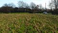
Hash surroundings, two sides of the field were lined with a very big allotment, each small garden seemed to hold its own hut.
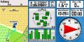
And GPS coordinates on another gadget... :)


Achievements
Not noteworthy. ;) Land? Easy?