Difference between revisions of "2017-01-07 -41 175"
imported>FippeBot m (Location) |
(Categories) |
||
| (One intermediate revision by one other user not shown) | |||
| Line 61: | Line 61: | ||
}} | }} | ||
| − | |||
| − | |||
| − | |||
| − | |||
| − | |||
| − | |||
| − | |||
| − | |||
| − | |||
| − | |||
| − | |||
| − | |||
| − | |||
[[Category:Expeditions with photos]] | [[Category:Expeditions with photos]] | ||
| − | + | [[Category:Not reached - Did not attempt]] | |
| − | [[Category: | ||
| − | |||
| − | |||
| − | |||
| − | |||
| − | |||
| − | |||
| − | |||
| − | |||
| − | |||
| − | |||
| − | |||
| − | |||
| − | |||
| − | |||
| − | |||
| − | |||
| − | |||
| − | |||
| − | |||
| − | |||
| − | |||
| − | |||
| − | |||
{{location|NZ|WGN}} | {{location|NZ|WGN}} | ||
Latest revision as of 11:27, 15 September 2022
| Sat 7 Jan 2017 in -41,175: -41.1405298, 175.2637058 geohashing.info google osm bing/os kml crox |
Location
200m off the Wairarapa train line, south of featherston.
Participants
Plans
After Hugh and Adelle rode an "old timey train" from Paekakariki to Masterton, they decided to just use the commuter service back home, instead of the return steam locamotive. Upon checking the geohash location, Hugh saw that it was a mere 200 meters from the track along the route. Not the closest hash, but still gave it a go.
Expedition
Caught 4:40pm train from Masterton, and rode just shy of 200 meters past the hash at around 5:30pm. The hash location was up a very steep hill covered with gorse, so unsure whether it would really be accessible.
Sadly, we had already eaten our home baked pie, so we miss out on the Pie Geohash achievement.
Tracklog
Photos
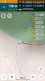
Got as close as we could. 198m away. Dense gorse between us and it.
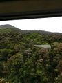
The gorse


Achievements
Hugh and Adelle earned the Public transport geohash achievement
|