Difference between revisions of "2017-02-21 49 8"
imported>DODO (→Location) |
imported>FippeBot m (Location) |
||
| (2 intermediate revisions by one other user not shown) | |||
| Line 25: | Line 25: | ||
<!-- who attended: If you link to your wiki user name in this section, your expedition will be picked up by the various statistics generated for geohashing. You may use three tildes ~ as a shortcut to automatically insert the user signature of the account you are editing with. | <!-- who attended: If you link to your wiki user name in this section, your expedition will be picked up by the various statistics generated for geohashing. You may use three tildes ~ as a shortcut to automatically insert the user signature of the account you are editing with. | ||
--> | --> | ||
| + | [[User:DODO|DODO]] | ||
== Plans == | == Plans == | ||
<!-- what were the original plans --> | <!-- what were the original plans --> | ||
| + | The hash is less than one KM apart from my (bycicle-) way to the office. So I just have to go there, although I have to go to work by car today. | ||
== Expedition == | == Expedition == | ||
<!-- how it all turned out. your narrative goes here. --> | <!-- how it all turned out. your narrative goes here. --> | ||
| + | So easy. I took the bicycle-way to the office with the car. Although it takes much more time it is even 7 kilometers shorter than the usual way along the autobahn. Just before I reached Ketsch I turned right and drove for 700 meters. There was a parking lot because you can swim in the nearby lake in summer. Of course, today I was the only one parking there. Now I was 50 m from the hash as the crow flies, but I had to walk a little more because the Kraischbach (ditch) was still between us. But 100m further was a bridge. So the way was 100m east, cross the bridge, 100 m west, hash, 100 m east, bridge, 100 m west car. The hash itself was at the slope of the dike, much closer to the top than I expected from aunt google. I took some pictures and was back at the car 10 minutes after I left. | ||
== Tracklog == | == Tracklog == | ||
<!-- if your GPS device keeps a log, you may post a link here --> | <!-- if your GPS device keeps a log, you may post a link here --> | ||
| − | + | [https://www.komoot.de/tour/14363326 500 m by foot]. Additional 1,5 KM by car. Or 5 KM less than usual, if you see it that way. | |
== Photos == | == Photos == | ||
<!-- Insert pictures between the gallery tags using the following format: | <!-- Insert pictures between the gallery tags using the following format: | ||
Image:2012-##-## ## ## Alpha.jpg | Witty Comment | Image:2012-##-## ## ## Alpha.jpg | Witty Comment | ||
--> | --> | ||
| − | <gallery perrow=" | + | <gallery perrow="4"> |
| + | Image:2017-02-21_49_8-7.png|50 m from car to hash | ||
| + | Image:2017-02-21_49_8-1.jpg|view to the hash | ||
| + | Image:2017-02-21_49_8-8.png|proof | ||
| + | Image:2017-02-21_49_8-2.jpg|view from the hash to the north, the house behind the trees is a restaurant with one Michelin-star | ||
| + | Image:2017-02-21_49_8-3.jpg|view to the south and the ditch | ||
| + | Image:2017-02-21_49_8-4.jpg|to the east and the bridge | ||
| + | Image:2017-02-21_49_8-5.jpg|and to the hasher | ||
| + | Image:2017-02-21_49_8-6.jpg|accidental hasher walking her dog | ||
</gallery> | </gallery> | ||
| Line 45: | Line 56: | ||
{{#vardefine:ribbonwidth|800px}} | {{#vardefine:ribbonwidth|800px}} | ||
<!-- Add any achievement ribbons you earned below, or remove this section --> | <!-- Add any achievement ribbons you earned below, or remove this section --> | ||
| − | + | {{land geohash | |
| − | + | | latitude = 49 | |
| − | + | | longitude = 8 | |
| − | + | | date = 2017-02-21 | |
| − | + | | name = [[User:DODO|DODO]] | |
| − | + | }} | |
| − | |||
| − | |||
| − | |||
| − | [[ | ||
| − | |||
| − | |||
| − | |||
| − | |||
| − | |||
[[Category:Expeditions]] | [[Category:Expeditions]] | ||
| − | |||
| − | |||
| − | |||
| − | |||
| − | |||
| − | |||
| − | |||
[[Category:Coordinates reached]] | [[Category:Coordinates reached]] | ||
| − | + | {{location|DE|BW|HD}} | |
| − | |||
| − | |||
| − | |||
| − | |||
| − | |||
| − | |||
| − | |||
| − | |||
| − | |||
| − | |||
| − | |||
| − | |||
| − | |||
| − | |||
| − | |||
| − | |||
| − | |||
Latest revision as of 02:09, 16 August 2019
| Tue 21 Feb 2017 in 49,8: 49.3565666, 8.5187660 geohashing.info google osm bing/os kml crox |
Location
A dike at the Kraichbach near Ketsch.
Participants
Plans
The hash is less than one KM apart from my (bycicle-) way to the office. So I just have to go there, although I have to go to work by car today.
Expedition
So easy. I took the bicycle-way to the office with the car. Although it takes much more time it is even 7 kilometers shorter than the usual way along the autobahn. Just before I reached Ketsch I turned right and drove for 700 meters. There was a parking lot because you can swim in the nearby lake in summer. Of course, today I was the only one parking there. Now I was 50 m from the hash as the crow flies, but I had to walk a little more because the Kraischbach (ditch) was still between us. But 100m further was a bridge. So the way was 100m east, cross the bridge, 100 m west, hash, 100 m east, bridge, 100 m west car. The hash itself was at the slope of the dike, much closer to the top than I expected from aunt google. I took some pictures and was back at the car 10 minutes after I left.
Tracklog
500 m by foot. Additional 1,5 KM by car. Or 5 KM less than usual, if you see it that way.
Photos
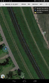
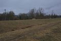
50 m from car to hash
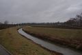
view to the hash
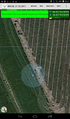
proof
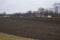
view from the hash to the north, the house behind the trees is a restaurant with one Michelin-star
view to the south and the ditch
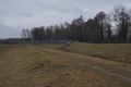
to the east and the bridge

and to the hasher
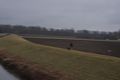
accidental hasher walking her dog


Achievements
DODO earned the Land geohash achievement
|