Difference between revisions of "2017-03-19 51 4"
imported>FelixTheCat (Created page with "{{subst:Expedition |lat = 51 |lon = 4 |date = 2017-03-19 }}") |
imported>FelixTheCat |
||
| Line 1: | Line 1: | ||
| − | |||
| − | |||
| − | |||
| − | |||
| − | |||
| − | |||
| − | |||
| − | |||
| − | |||
| − | |||
{{meetup graticule | {{meetup graticule | ||
| lat=51 | | lat=51 | ||
| Line 14: | Line 4: | ||
| date=2017-03-19 | | date=2017-03-19 | ||
}} | }} | ||
| − | |||
| − | |||
__NOTOC__ | __NOTOC__ | ||
| − | |||
== Location == | == Location == | ||
| − | + | Akkerdijksche polder in Schipluiden, just south of Delft. Municipality of Midden-Delfland. | |
== Participants == | == Participants == | ||
| − | + | [[User:FelixTheCat|FelixTheCat]] ([[User talk:FelixTheCat|talk]]) | |
| − | |||
| − | |||
| − | |||
| − | |||
== Expedition == | == Expedition == | ||
| − | + | The weather wasn't great today, but at least it wasn't raining, so I got on my bike and rode towards the polders beyond the southern edge of Delft. It looked like the hash was on a farmer's field, which are usually No Trespassing areas, protected by ditches and fences and angry livestock. But as it turned out, this bit of field was open to the public as part of a hiking trail. I took some pictures, walked around a bit and then rode home again. | |
| − | + | It's been a while since I've done a bicycle geohash. Should do that more often... | |
| − | |||
== Photos == | == Photos == | ||
| − | |||
| − | |||
| − | |||
<gallery perrow="5"> | <gallery perrow="5"> | ||
| + | Image:2017-03-19 51 4 FelixTheCat 1.JPG | The polders to the south of Delft. In front the Southern Delfgauw Polder, behind it our target: the Akkerdijksche Polder. | ||
| + | Image:2017-03-19 51 4 FelixTheCat 2.JPG | It's Sunday, so bike paths in the country are full of cyclists. | ||
| + | Image:2017-03-19 51 4 FelixTheCat 3.JPG | The gate to this field is actually open! | ||
| + | Image:2017-03-19 51 4 FelixTheCat 4.JPG | It's the entrance to a "Boerenpad", or "Farmer's trail". | ||
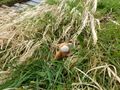
| + | Image:2017-03-19 51 4 FelixTheCat 5.JPG | Here, just next to a drainage ditch, is the hashpoint. | ||
| + | Image:2017-03-19 51 4 FelixTheCat 6.png | GPS proof. | ||
| + | Image:2017-03-19 51 4 FelixTheCat 7.JPG | Lloyd posing at the hash. | ||
| + | Image:2017-03-19 51 4 FelixTheCat 8.JPG | The rest of the field, looking west. | ||
</gallery> | </gallery> | ||
== Achievements == | == Achievements == | ||
{{#vardefine:ribbonwidth|800px}} | {{#vardefine:ribbonwidth|800px}} | ||
| − | + | {{bicycle geohash | |
| + | | latitude = 51 | ||
| + | | longitude = 4 | ||
| + | | date = 2017-03-19 | ||
| + | | name = [[User:FelixTheCat|FelixTheCat]] ([[User talk:FelixTheCat|talk]]) | ||
| + | | distance = 14.5 km | ||
| + | | bothways = true | ||
| + | }} | ||
| − | |||
| − | |||
| − | |||
| − | |||
| − | |||
| − | |||
| − | |||
| − | |||
| − | |||
| − | |||
| − | |||
| − | |||
| − | |||
| − | |||
[[Category:Expeditions]] | [[Category:Expeditions]] | ||
| − | |||
[[Category:Expeditions with photos]] | [[Category:Expeditions with photos]] | ||
| − | |||
| − | |||
| − | |||
| − | |||
| − | |||
[[Category:Coordinates reached]] | [[Category:Coordinates reached]] | ||
| − | |||
| − | |||
| − | |||
| − | |||
| − | |||
| − | |||
| − | |||
| − | |||
| − | |||
| − | |||
| − | |||
| − | |||
| − | |||
| − | |||
| − | |||
| − | |||
| − | |||
| − | |||
Revision as of 22:09, 20 March 2017
| Sun 19 Mar 2017 in 51,4: 51.9683167, 4.4009762 geohashing.info google osm bing/os kml crox |
Location
Akkerdijksche polder in Schipluiden, just south of Delft. Municipality of Midden-Delfland.
Participants
Expedition
The weather wasn't great today, but at least it wasn't raining, so I got on my bike and rode towards the polders beyond the southern edge of Delft. It looked like the hash was on a farmer's field, which are usually No Trespassing areas, protected by ditches and fences and angry livestock. But as it turned out, this bit of field was open to the public as part of a hiking trail. I took some pictures, walked around a bit and then rode home again.
It's been a while since I've done a bicycle geohash. Should do that more often...
Photos
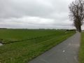
The polders to the south of Delft. In front the Southern Delfgauw Polder, behind it our target: the Akkerdijksche Polder.
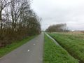
It's Sunday, so bike paths in the country are full of cyclists.

The gate to this field is actually open!
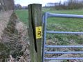
It's the entrance to a "Boerenpad", or "Farmer's trail".
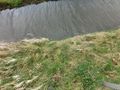
Here, just next to a drainage ditch, is the hashpoint.
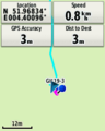
GPS proof.
Lloyd posing at the hash.
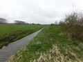
The rest of the field, looking west.


Achievements
FelixTheCat (talk) earned the Bicycle geohash achievement
|