Difference between revisions of "2017-04-12 48 2"
From Geohashing
imported>Dunaril |
imported>FippeBot m (Location) |
||
| (5 intermediate revisions by one other user not shown) | |||
| Line 1: | Line 1: | ||
| + | [[Image:{{{image|2017-04-12_48_2_Dunaril_1492018816470.jpg}}}|thumb|left]] | ||
{{meetup graticule | {{meetup graticule | ||
| lat=48 | | lat=48 | ||
| Line 4: | Line 5: | ||
| date=2017-04-12 | | date=2017-04-12 | ||
}} | }} | ||
| − | |||
__NOTOC__ | __NOTOC__ | ||
| − | |||
== Location == | == Location == | ||
On the left back in Paris, right on the sidewalk at a large square (Place de Breteuil). | On the left back in Paris, right on the sidewalk at a large square (Place de Breteuil). | ||
| Line 17: | Line 16: | ||
== Expedition == | == Expedition == | ||
| − | The expedition went quite as expected and I could zero out on the geohash quickly. I then went to find back a nearby geocache I had already logged a few years ago - I had wanted to get this Hash collision achievement for a long time! | + | The expedition went quite as expected and I could zero out on the geohash quickly. I then went to find back a nearby geocache I had already logged a few years ago - I had wanted to get this Hash collision achievement for a long time! And I think that also qualifies for a Dejà Vu. |
== Photos == | == Photos == | ||
| − | <gallery | + | <gallery> |
Image:2017-04-12_48_2_Dunaril_1492018497974.jpg|There! [http://www.openstreetmap.org/?lat=48.84749100&lon=2.31236150&zoom=16&layers=B000FTF @48.8475,2.3124] | Image:2017-04-12_48_2_Dunaril_1492018497974.jpg|There! [http://www.openstreetmap.org/?lat=48.84749100&lon=2.31236150&zoom=16&layers=B000FTF @48.8475,2.3124] | ||
| Line 33: | Line 32: | ||
Image:2017-04-12_48_2_Dunaril_1492018816470.jpg|Nearby bistro [http://www.openstreetmap.org/?lat=48.84750320&lon=2.31232980&zoom=16&layers=B000FTF @48.8475,2.3123] | Image:2017-04-12_48_2_Dunaril_1492018816470.jpg|Nearby bistro [http://www.openstreetmap.org/?lat=48.84750320&lon=2.31232980&zoom=16&layers=B000FTF @48.8475,2.3123] | ||
| − | |||
| − | |||
Image:2017-04-12_48_2_Dunaril_1492019230399.jpg|The hash seen from the cache [http://www.openstreetmap.org/?lat=48.84684900&lon=2.31222480&zoom=16&layers=B000FTF @48.8468,2.3122] | Image:2017-04-12_48_2_Dunaril_1492019230399.jpg|The hash seen from the cache [http://www.openstreetmap.org/?lat=48.84684900&lon=2.31222480&zoom=16&layers=B000FTF @48.8468,2.3122] | ||
Image:2017-04-12_48_2_Dunaril_1492019252492.jpg|Cache and hash [http://www.openstreetmap.org/?lat=48.84685100&lon=2.31222450&zoom=16&layers=B000FTF @48.8469,2.3122] | Image:2017-04-12_48_2_Dunaril_1492019252492.jpg|Cache and hash [http://www.openstreetmap.org/?lat=48.84685100&lon=2.31222450&zoom=16&layers=B000FTF @48.8469,2.3122] | ||
| + | |||
</gallery> | </gallery> | ||
| Line 45: | Line 43: | ||
| + | {{land geohash | ||
| + | | latitude = 48 | ||
| + | | longitude = 2 | ||
| + | | date = 2017-04-12 | ||
| + | | name = [[User:Dunaril|Dunaril]] | ||
| + | | image = 2017-04-12_48_2_Dunaril_1492018764243.jpg | ||
| + | }} | ||
| + | |||
| + | {{Hash collision | ||
| + | | latitude = 48 | ||
| + | | longitude = 2 | ||
| + | | date = 2017-04-12 | ||
| + | | name = [[User:Dunaril|Dunaril]] | ||
| + | | link = https://www.geocaching.com/geocache/GC24HV4 | ||
| + | | image = 2017-04-12_48_2_Dunaril_1492019212444.jpg | ||
| + | | id = GC24HV4 | ||
| + | | distance = 75m }} | ||
| + | |||
| + | {{Déjà vu geohash | ||
| + | | latitude = 48 | ||
| + | | longitude = 2 | ||
| + | | date = 2017-04-12 | ||
| + | | olddate = [https://www.geocaching.com/seek/log.aspx?LUID=9ff9b0a3-c9fe-4d6e-b238-0a02ce5560b2 '''2014-02-20'''] | ||
| + | | name = [[User:Dunaril|Dunaril]] | ||
| + | | image = 2017-04-12_48_2_Dunaril_1492018706153.jpg | ||
| + | }} | ||
[[Category:Expeditions]] | [[Category:Expeditions]] | ||
| Line 50: | Line 74: | ||
[[Category:Coordinates reached]] | [[Category:Coordinates reached]] | ||
| + | {{location|FR|75}} | ||
Latest revision as of 02:27, 7 August 2019

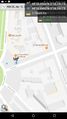
| Wed 12 Apr 2017 in 48,2: 48.8475072, 2.3123621 geohashing.info google osm bing/os kml crox |
Location
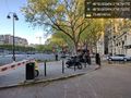
On the left back in Paris, right on the sidewalk at a large square (Place de Breteuil).
Participants
Dunaril (talk) is planning to come in the evening.
Plans
No more plans than just passing back on my evening commute.
Expedition
The expedition went quite as expected and I could zero out on the geohash quickly. I then went to find back a nearby geocache I had already logged a few years ago - I had wanted to get this Hash collision achievement for a long time! And I think that also qualifies for a Dejà Vu.
Photos
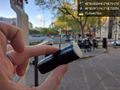
There! @48.8475,2.3124

Grin on the spot @48.8475,2.3124

Another selfie near the spot @48.8475,2.3124
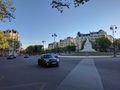
Place de Breteuil.
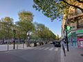
Invalides
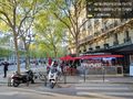
Nearby bistro @48.8475,2.3123
The hash seen from the cache @48.8468,2.3122
Cache and hash @48.8469,2.3122


Achievements
Dunaril earned the Land geohash achievement
|
Dunaril earned the Hash collision achievement
|
Dunaril earned the Déjà Vu Geohash Achievement
|