Difference between revisions of "2017-04-14 52 11"
From Geohashing
imported>Klaus (template) |
imported>FippeBot m (Location) |
||
| (One intermediate revision by one other user not shown) | |||
| Line 1: | Line 1: | ||
| − | + | [[Image:{{{image|2017-04-14_52_11_view_from_geohash_1.jpg}}}|thumb|left]] | |
| − | |||
| − | |||
| − | |||
| − | |||
| − | |||
| − | |||
| − | |||
{{meetup graticule | {{meetup graticule | ||
| lat=52 | | lat=52 | ||
| Line 15: | Line 8: | ||
}} | }} | ||
| − | |||
__NOTOC__ | __NOTOC__ | ||
== Location == | == Location == | ||
| − | + | Standortübungsplatz Burg-Krähenberge | |
== Participants == | == Participants == | ||
| − | + | * [[User:Klaus|Klaus]] | |
| − | + | * his girlfriend | |
== Plans == | == Plans == | ||
| − | + | During easter, I was staying around Magdeburg with my girlfriend. | |
| + | This hash was quite near and a unique chance to get a new graticule. | ||
| + | However I was unsure if it would be reachable because it's actually military ground. | ||
== Expedition == | == Expedition == | ||
| − | + | It was quite unspectacular. | |
| + | We parked at the street, walked to the hash (without disregarding any borders of the military area) and arrived at the hash. | ||
| − | |||
| − | |||
== Photos == | == Photos == | ||
| − | |||
| − | |||
| − | |||
<gallery perrow="5"> | <gallery perrow="5"> | ||
| + | Image:2017-04-14_52_11_sign.jpg | The Sign says: "Border of the military security area / Touching and acquisition of gear ammunition or ammunition parts is forbidden" (we didn't need to go beyond this sign) | ||
| + | Image:2017-04-14_52_11_view_from_geohash_1.jpg | View from hash #1 | ||
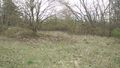
| + | Image:2017-04-14_52_11_view_from_geohash_2.jpg | View from hash #2 | ||
| + | Image:2017-04-14_52_11_view_from_geohash_3.jpg | View from hash #3 | ||
| + | Image:2017-04-14_52_11_view_from_geohash_4.jpg | View from hash #4 | ||
| + | Image:2017-04-14_52_11_view_back_to_geohash.jpg | View back, geohash in the middle | ||
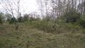
| + | Image:2017-04-14_52_11_bunker.jpg | A trench in the public area | ||
</gallery> | </gallery> | ||
== Achievements == | == Achievements == | ||
{{#vardefine:ribbonwidth|800px}} | {{#vardefine:ribbonwidth|800px}} | ||
| − | |||
| − | |||
| − | |||
| − | |||
| − | + | {{land geohash | |
| + | | latitude = 52 | ||
| + | | longitude = 11 | ||
| + | | date = 2017-04-14 | ||
| + | | name = [[User:Klaus|Klaus]] | ||
| + | }} | ||
| − | |||
| − | |||
| − | |||
| − | |||
| − | + | {{Template:Drag-along | |
| + | | latitude = 52 | ||
| + | | longitude = 11 | ||
| + | | date = 2017-04-14 | ||
| + | | name = [[User:Klaus|Klaus]] | ||
| + | | partner = his girlfriend | ||
| + | }} | ||
| − | |||
[[Category:Expeditions]] | [[Category:Expeditions]] | ||
| − | |||
[[Category:Expeditions with photos]] | [[Category:Expeditions with photos]] | ||
| − | |||
| − | |||
| − | |||
| − | |||
| − | |||
[[Category:Coordinates reached]] | [[Category:Coordinates reached]] | ||
| − | + | {{location|DE|ST|JL}} | |
| − | |||
| − | |||
| − | |||
| − | |||
| − | |||
| − | |||
| − | |||
| − | |||
| − | |||
| − | |||
| − | |||
| − | |||
| − | |||
| − | |||
| − | |||
| − | |||
| − | |||
Latest revision as of 02:27, 7 August 2019

| Fri 14 Apr 2017 in 52,11: 52.2461103, 11.8713271 geohashing.info google osm bing/os kml crox |
Location
Standortübungsplatz Burg-Krähenberge
Participants
- Klaus
- his girlfriend
Plans
During easter, I was staying around Magdeburg with my girlfriend. This hash was quite near and a unique chance to get a new graticule. However I was unsure if it would be reachable because it's actually military ground.
Expedition
It was quite unspectacular. We parked at the street, walked to the hash (without disregarding any borders of the military area) and arrived at the hash.
Photos
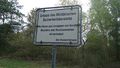
The Sign says: "Border of the military security area / Touching and acquisition of gear ammunition or ammunition parts is forbidden" (we didn't need to go beyond this sign)
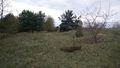
View from hash #1
View from hash #2
View from hash #3
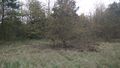
View from hash #4
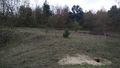
View back, geohash in the middle
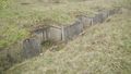
A trench in the public area


Achievements
Klaus earned the Land geohash achievement
|
Klaus earned the Drag-along achievement
|